
Find the best routes to Spencer Street, Docklands

See Spencer Street, Docklands, on the map

Directions to Spencer Street (Docklands) with public transport

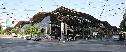
The following transport lines have routes that pass near Spencer Street

  • BusBus: 
  • TrainTrain: 
  • TramTram: 

How to get to Spencer Street by bus?

Click on the bus route to see step by step directions with maps, line arrival times and updated time schedules.

How to get to Spencer Street by train?

Click on the train route to see step by step directions with maps, line arrival times and updated time schedules.

Tram stations near Spencer Street in Docklands

  • 119-La Trobe St/Spencer St (Melbourne City),1 min walk,
  • 1-Spencer St/La Trobe St (Melbourne City),1 min walk,
  • 2-King St/La Trobe St (Melbourne City),3 min walk,

Bus stations near Spencer Street in Docklands

  • Jeffcott St/Spencer St (West Melbourne),3 min walk,
  • Southern Cross Coach Terminal/Spencer St (Melbourne City),4 min walk,
  • Skybus Coach Terminal/Spencer St (Melbourne City),5 min walk,
  • Spencer St/Dudley St (West Melbourne),6 min walk,
  • King St/Lonsdale St (Melbourne City),7 min walk,

Bus lines to Spencer Street in Docklands

  • 216,Sunshine Station,
  • ADELAIDE - MELBOURNE VIA BENDIGO & NHILL,Adelaide - Melbourne Via Bendigo & Nhill,
  • ARARAT - MELBOURNE VIA BALLARAT,Ararat - Melbourne Via Ballarat,
  • BAIRNSDALE VIA TRARALGON & SALE,Bairnsdale Via Traralgon & Sale,
  • BALLARAT - MELBOURNE VIA MELTON,Ballarat - Melbourne Via Melton,
  • BALLARAT VIA MELTON,Ballarat Via Melton,
  • BENDIGO VIA SUNBURY,Bendigo Via Sunbury,
  • GEELONG - MELBOURNE VIA GEELONG,Geelong - Melbourne Via Geelong,
  • MELBOURNE - BARHAM VIA HEATHCOTE,Melbourne - Barham Via Heathcote,
  • MELBOURNE - BARMAH VIA SHEPPARTON & HEATHCOTE,Melbourne - Barmah Via Shepparton & Heathcote,
  • MELBOURNE - BENDIGO VIA SUNBURY,Melbourne - Bendigo Via Sunbury,
  • MELBOURNE - DENILIQUIN VIA ECHUCA & HEATHCOTE,Melbourne - Deniliquin Via Echuca & Heathcote,
  • MELBOURNE - ECHUCA/MOAMA VIA BENDIGO OR HEATHCOTE,Melbourne - Echuca/Moama Via Bendigo or Heathcote,
  • MELBOURNE - MANSFIELD VIA YEA,Melbourne - Mansfield Via Yea,
  • MELBOURNE - MILDURA VIA DONALD & BALLARAT,Melbourne - Mildura Via Donald & Ballarat,
  • MELBOURNE - SEYMOUR VIA BROADMEADOWS,Melbourne - Seymour Via Broadmeadows,
  • MELBOURNE VIA MELTON,Melbourne Via Melton,
  • TRARALGON - MELBOURNE VIA PAKENHAM, MOE & MORWELL,Traralgon - Melbourne Via Pakenham, Moe & Morwell,
  • WARRNAMBOOL - MELBOURNE VIA GEELONG & COLAC,Warrnambool - Melbourne Via Geelong & Colac,
  • YARRAM - MELBOURNE VIA KOO WEE RUP & LEONGATHA,Yarram - Melbourne Via Koo Wee Rup & Leongatha,
Questions & Answers
  • What are the nearest stations to Spencer Street?

    The nearest stations to Spencer Street are:

    • 119-La Trobe St/Spencer St (Melbourne City) is 25 meters away, 1 min walk.
    • 1-Spencer St/La Trobe St (Melbourne City) is 35 meters away, 1 min walk.
    • Jeffcott St/Spencer St (West Melbourne) is 157 meters away, 3 min walk.
    • 2-King St/La Trobe St (Melbourne City) is 228 meters away, 3 min walk.
    • Southern Cross Coach Terminal/Spencer St (Melbourne City) is 242 meters away, 4 min walk.
    • Skybus Coach Terminal/Spencer St (Melbourne City) is 314 meters away, 5 min walk.
    • Spencer St/Dudley St (West Melbourne) is 408 meters away, 6 min walk.
    • King St/Lonsdale St (Melbourne City) is 508 meters away, 7 min walk.
  • Which bus lines stop near Spencer Street?

    These bus lines stop near Spencer Street: 216, 220, 235, 302, 546, 605.

  • Which train lines stop near Spencer Street?

    These train lines stop near Spencer Street: ALAMEIN, BELGRAVE, CRAIGIEBURN, CRANBOURNE, FRANKSTON, LILYDALE, MERNDA, SUNBURY, WILLIAMSTOWN.

  • Which tram line stops near Spencer Street?

    86

  • What’s the nearest tram station to Spencer Street in Docklands?

    The nearest tram stations to Spencer Street in Docklands are 119-La Trobe St/Spencer St (Melbourne City) and 1-Spencer St/La Trobe St (Melbourne City). The closest one is a 1 min walk away.

  • What’s the nearest bus stop to Spencer Street in Docklands?

    The nearest bus stop to Spencer Street in Docklands is Jeffcott St/Spencer St (West Melbourne). It’s a 3 min walk away.

  • What time is the first tram to Spencer Street in Docklands?

    The 86 is the first tram that goes to Spencer Street in Docklands. It stops nearby at 05:32.

  • What time is the last tram to Spencer Street in Docklands?

    The 109 is the last tram that goes to Spencer Street in Docklands. It stops nearby at 00:21.

  • What time is the first bus to Spencer Street in Docklands?

    The AVALON CITY EXPRESS is the first bus that goes to Spencer Street in Docklands. It stops nearby at 03:50.

  • What time is the last bus to Spencer Street in Docklands?

    The MELBOURNE - MILDURA VIA DONALD & BALLARAT is the last bus that goes to Spencer Street in Docklands. It stops nearby at 07:05.

  • How much is the bus fare to Spencer Street?

    The bus fare to Spencer Street costs about $3.30 - $5.30.

See Spencer Street, Docklands, on the map

The Most Popular Urban Mobility App in Docklands.
All local mobility options in one app

Public Transit to Spencer Street in Docklands

How to get to Spencer Street in Docklands, Australia?

It’s easy with Moovit. Type in your street address and Moovit’s route finder will locate the fastest way to get you there! Not sure where to get off on the street? Download the Moovit App to find live directions (including where to get off on Spencer Street), see timetables and get the estimated arrival times for your favourite train, bus or tram lines.

Looking for the nearest stop or station to Spencer Street? Check out this list of closest stops available to your destination: 119-La Trobe St/Spencer St (Melbourne City); 1-Spencer St/La Trobe St (Melbourne City); Jeffcott St/Spencer St (West Melbourne); 2-King St/La Trobe St (Melbourne City); Southern Cross Coach Terminal/Spencer St (Melbourne City); Skybus Coach Terminal/Spencer St (Melbourne City); Spencer St/Dudley St (West Melbourne); King St/Lonsdale St (Melbourne City).

Bus:Train:Tram:

Download the Moovit App to see the current schedule and routes available for Docklands. No need to install a special bus app to check the bus time or a train app to get train time. Moovit is the only all-in-one transport app that helps you get where you need to go.

We make riding on public transit to Spencer Street easy, which is why over 1.5 million users, including users in Docklands trust Moovit as the best app for public transport.

Use the app to navigate to popular places including to the airport, hospital, stadium, grocery store, mall, coffee shop, school, college, and university.

Location: Docklands, Melbourne

Spencer Street, Docklands
Spencer Street, DocklandsSpencer Street is a major street and thoroughfare in the Melbourne central business district, Victoria, Australia. The street was gazetted in 1837 as the westernmost boundary of the Hoddle Grid. Spencer Street is named for John Spencer, former Chancellor of the Exchequer in the United Kingdom. As the 3rd Earl of Spencer, he was the 2nd great uncle of The Princess of Wales, Diana Spencer. John's younger brother, Frederick, became the 4th Earl of Spencer on his brother's death. Frederick was Diana's 2nd great grandfather. On the 15th of April 1983, the Prince and Princess of Wales on their royal tour, departed Spencer Street Station for Ballarat, returning later that afternoon.
How to get to Spencer Street with public transport- About the place

Get around Docklands by public transport!

Travelling around Docklands has never been so easy. See step by step directions as you travel to any attraction, street or major public transport station. View bus and train timetables, arrival times, service alerts and detailed routes on a map, so you know exactly how to get to anywhere in Docklands.

When travelling to any destination around Docklands use Moovit's Live Directions with Get Off Notifications to know exactly where and how far to walk, how long to wait for your line , and how many stops are left. Moovit will alert you when it’s time to get off — no need to constantly re-check whether yours is the next stop.

Wondering how to use public transport in Docklands or how to pay for public transport in Docklands? Moovit public transport app can help you navigate your way with public transport easily, and at minimum cost. It includes public transport fees, ticket prices, and costs. Looking for a map of Docklands public transport lines? Moovit public transport app shows all public transport maps in Docklands with all train, bus or tram routes and stops on an interactive map.

Docklands has 3 transport type(s), including: train, bus or tram, operated by several transport agencies, including PTV Metropolitan Trains, PTV Metropolitan Bus, Yarra Trams, PTV Regional Bus, SkyBus, Interstate Services, V/Line and V/Line (Coach)

Public transport routes with stations closest to Spencer Street in Docklands

Bus lines with stations closest to Spencer Street in Docklands

Easier to get to Spencer Street in…