The Most Popular Urban Mobility App in East Midlands.
All local mobility options in one app
| Line | Direction | Time |
|---|---|---|
| 866 | Sutton Bonington | 07:46 |
| 01 | East Leake | 08:07 |
| 866 | Sutton Bonington | 08:46 |
| 07 | Long Eaton | 09:37 |
| 06 | West Bridgford | 09:37 |
| 02 | East Leake | 14:58 |
| 02 | East Leake | 15:51 |
| 866 | Sutton Bonington | 16:56 |
| 866 | Sutton Bonington | 17:56 |
The following transport lines have routes that pass near St Michaels Church, Sutton Bonington
Click on the Bus route to see step by step directions with maps, line arrival times and updated time schedules.
The nearest stations to St Michaels Church, Sutton Bonington are:
These Bus lines stop near St Michaels Church, Sutton Bonington: 901
The nearest bus stop to St Michaels Church, Sutton Bonington in East Midlands is Pasture Lane, Sutton Bonington. It’s a 6 min walk away.
The 901 is the first Bus that goes to St Michaels Church, Sutton Bonington in East Midlands. It stops nearby at 08:55.
The 901 is the last Bus that goes to St Michaels Church, Sutton Bonington in East Midlands. It stops nearby at 00:35.
Looking for directions to St Michaels Church, Sutton Bonington in East Midlands, United Kingdom?
Download the Moovit App to find the current schedule and step-by-step directions for Bus routes that pass through St Michaels Church, Sutton Bonington.
Looking for the nearest stops closest to St Michaels Church, Sutton Bonington ? Check out this list of closest stops to your destination: Pasture Lane; University Of Nottingham Campus.
Bus:
We make riding on public transit to St Michaels Church, Sutton Bonington easy, which is why over 1.5 million users, including users in East Midlands trust Moovit as the best app for public transit.
Use the app to navigate to popular places including to the airport, hospital, stadium, grocery store, mall, coffee shop, school, college, and university.
St Michaels Church, Sutton Bonington stop’s code is ntsajgdp
The first line to this stop is 866, at 07:46, and the last line is 866 at 17:56.
129B Main Street, Sutton Bonington Civil Parish, England, United Kingdom
This stop serves Soar Valley Community Bus and Centrebus’s lines
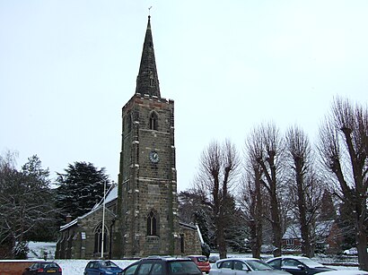
St. Michael's Church is a parish church in the Church of England in Sutton Bonington, Nottinghamshire. The church is a 13th-century Grade II* Listed building.Wiki