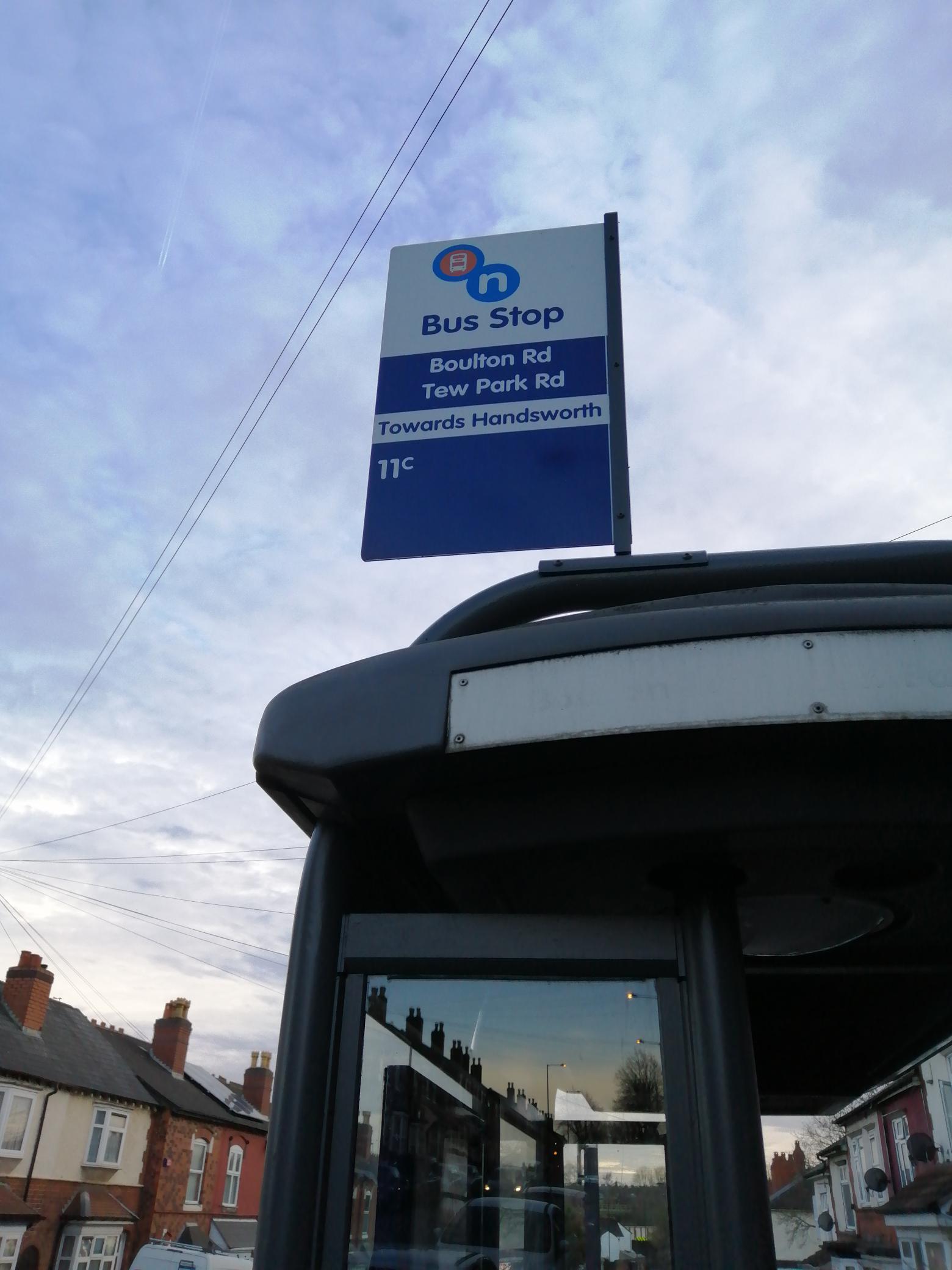
Tew Park Rd stop - Monday schedule
| Line | Direction | Time |
|---|---|---|
| 11C | Six Ways | 04:52 |
| 11C | Six Ways | 05:12 |
| 11C | Six Ways | 05:33 |
| 11C | Six Ways | 05:46 |
| 11C | Six Ways | 06:07 |
| 11C | Six Ways | 06:20 |
| 11C | Six Ways | 06:29 |
| 11C | Six Ways | 06:39 |
| 11C | Six Ways | 06:47 |
| 11C | Six Ways | 06:56 |
| 11C | Six Ways | 07:04 |
| 11C | Six Ways | 07:13 |
| 11C | Six Ways | 07:20 |
| 11C | Six Ways | 07:28 |
| 11C | Six Ways | 07:35 |
| 11C | Six Ways | 07:42 |
| 11C | Six Ways | 07:51 |
| 11C | Six Ways | 08:00 |
| 11C | Six Ways | 08:08 |
| 11C | Six Ways | 08:16 |
| 11C | Six Ways | 08:26 |
| 11C | Six Ways | 08:36 |
| 11C | Six Ways | 08:46 |
| 11C | Six Ways | 08:55 |
| 11C | Six Ways | 09:04 |
Directions to Tew Park Rd stop (Soho & Jewellery Quarter) with public transport
The following transport lines have routes that pass near Tew Park Rd
 Bus: 101, 11A, 11C, 74, NB2.
- Train: WEST MIDLANDS RAILWAY, CHILTERN RAILWAYS.
- Light rail: METRO.
How to get to Tew Park Rd stop by bus?
Click on the bus route to see step by step directions with maps, line arrival times and updated time schedules.
How to get to Tew Park Rd stop by train?
Click on the train route to see step by step directions with maps, line arrival times and updated time schedules.
Bus stops near Tew Park Rd stop in Soho & Jewellery Quarter
- Winson Green Metro Stop, 3 min walk,
- Winson Green Metro, 4 min walk,
- Soho Rd, 4 min walk,
- Boulton Rd, 6 min walk,
Train stations near Tew Park Rd station in Soho & Jewellery Quarter
- The Hawthorns, 13 min walk,
Light Rail stations near Tew Park Rd station in Soho & Jewellery Quarter
- The Hawthorns (West Midlands Metro), 14 min walk,
Bus lines to Tew Park Rd stop in Soho & Jewellery Quarter
- 11A, Serpentine Rd,
- 101, Colmore Row,
- NB2, Priory Way / Norwood Green, Southall,
- 11C, Six Ways,
- 74, West Bromwich Bus Station,
What are the nearest stations to Tew Park Rd?
The nearest stations to Tew Park Rd are:
- Winson Green Metro Stop is 207 meters away, 3 min walk.
- Winson Green Metro is 270 meters away, 4 min walk.
- Soho Rd is 288 meters away, 4 min walk.
- Boulton Rd is 398 meters away, 6 min walk.
- The Hawthorns is 906 meters away, 13 min walk.
- The Hawthorns (West Midlands Metro) is 906 meters away, 14 min walk.
Which bus lines stop near Tew Park Rd?
These bus lines stop near Tew Park Rd: 101, 11A, 11C, 74.
Which train line stops near Tew Park Rd?
WEST MIDLANDS RAILWAY (Wolverhampton)
Which light rail line stops near Tew Park Rd?
METRO (Wolverhampton Station)
What’s the nearest light rail station to Tew Park Rd in Soho & Jewellery Quarter?
The nearest light rail station to Tew Park Rd in Soho & Jewellery Quarter is The Hawthorns (West Midlands Metro). It’s a 14 min walk away.
What’s the nearest train station to Tew Park Rd in Soho & Jewellery Quarter?
The nearest train station to Tew Park Rd in Soho & Jewellery Quarter is The Hawthorns. It’s a 13 min walk away.
What’s the nearest bus station to Tew Park Rd in Soho & Jewellery Quarter?
The nearest bus station to Tew Park Rd in Soho & Jewellery Quarter is Winson Green Metro Stop. It’s a 3 min walk away.
What time is the first light rail to Tew Park Rd in Soho & Jewellery Quarter?
The METRO is the first light rail that goes to Tew Park Rd in Soho & Jewellery Quarter. It stops nearby at 04:42.
What time is the last light rail to Tew Park Rd in Soho & Jewellery Quarter?
The METRO is the last light rail that goes to Tew Park Rd in Soho & Jewellery Quarter. It stops nearby at 00:56.
What time is the first train to Tew Park Rd in Soho & Jewellery Quarter?
The WEST MIDLANDS RAILWAY is the first train that goes to Tew Park Rd in Soho & Jewellery Quarter. It stops nearby at 06:08.
What time is the last train to Tew Park Rd in Soho & Jewellery Quarter?
The WEST MIDLANDS RAILWAY is the last train that goes to Tew Park Rd in Soho & Jewellery Quarter. It stops nearby at 23:42.
What time is the first bus to Tew Park Rd in Soho & Jewellery Quarter?
The 74 is the first bus that goes to Tew Park Rd in Soho & Jewellery Quarter. It stops nearby at 03:38.
What time is the last bus to Tew Park Rd in Soho & Jewellery Quarter?
The 74 is the last bus that goes to Tew Park Rd in Soho & Jewellery Quarter. It stops nearby at 01:18.
Tew Park Rd station
 Taken by Anonymous
See Tew Park Rd stop, Soho & Jewellery Quarter, on the map
Public transport to Tew Park Rd stop (ID: nwmgjmam) in Soho & Jewellery Quarter
Looking for directions to Tew Park Rd in Soho & Jewellery Quarter, United Kingdom?
Download the Moovit App to find the current schedule and step-by-step directions for Bus, Light rail or Train routes that pass through Tew Park Rd.
Looking for the nearest stops closest to Tew Park Rd ? Check out this list of closest stops to your destination: Winson Green Metro Stop; Winson Green Metro; Soho Rd; Boulton Rd; The Hawthorns; The Hawthorns (West Midlands Metro).
Bus: 101, 11A, 11C, 74, NB2.Train: WEST MIDLANDS RAILWAY, CHILTERN RAILWAYS.Light rail: METRO.
We make riding on public transit to Tew Park Rd easy, which is why over 1.5 million users, including users in Soho & Jewellery Quarter trust Moovit as the best app for public transit.
Use the app to navigate to popular places including to the airport, hospital, stadium, grocery store, mall, coffee shop, school, college, and university.
Tew Park Rd stop’s code is nwmgjmam
The first line to this stop is 11C, at 04:52, and the last line is 11C at 00:23.
121 Boulton Road, Birmingham, England, United Kingdom
This stop serves National Express West Midlands’s lines
- Winson Green Metro Stop,
- Winson Green Metro,
- Soho Rd,
- Boulton Rd
Bus stops near Tew Park Rd stop
- The Hawthorns
Train station near Tew Park Rd station
- The Hawthorns (West Midlands Metro)
Light Rail station near Tew Park Rd station
- Fordhouse Lane,
- Redditch Bus Station,
- Tamar Drive,
- Wakes Ground,
- Martley Rd,
- Darlaston Asda,
- Bristol Rd,
- Deykin Ave,
- James Watt College,
- Bournville Lane,
- Tamworth,
- Swan Island,
- Winson Green Prison,
- Bluebell Drive,
- West Heath Hospital,
- Portland Rd,
- Gleads Croft,
- Pendeford Trading Estate,
- Peartree Lane,
- Corporation St
Popular public transport stations in Soho & Jewellery Quarter
Get around Soho & Jewellery Quarter by public transport!
Travelling around Soho & Jewellery Quarter has never been so easy. See step by step directions as you travel to any attraction, street or major public transport station. View bus and train timetables, arrival times, service alerts and detailed routes on a map, so you know exactly how to get to anywhere in Soho & Jewellery Quarter.
When travelling to any destination around Soho & Jewellery Quarter use Moovit's Live Directions with Get Off Notifications to know exactly where and how far to walk, how long to wait for your line , and how many stops are left. Moovit will alert you when it’s time to get off — no need to constantly re-check whether yours is the next stop.
Wondering how to use public transport in Soho & Jewellery Quarter or how to pay for public transport in Soho & Jewellery Quarter? Moovit public transport app can help you navigate your way with public transport easily, and at minimum cost. It includes public transport fees, ticket prices, and costs. Looking for a map of Soho & Jewellery Quarter public transport lines? Moovit public transport app shows all public transport maps in Soho & Jewellery Quarter with all Bus, Train and Light rail routes and stops on an interactive map.
West Midlands has 3 transport type(s), including: Bus, Train and Light rail, operated by several transport agencies, including National Express West Midlands, National Express Coventry, National Express, Diamond Bus, Arriva Midlands, Stagecoach Midlands, West Midlands Metro, Stagecoach West, Stagecoach South Wales, First Potteries, First Worcestershire, LandFlight, trentbarton, D & G Bus and Flexibus