See The Workhouse, Southwell, Newark And Sherwood, on the map
Directions to The Workhouse, Southwell (Newark And Sherwood) with public transport
The following transport lines have routes that pass near The Workhouse, Southwell
 Bus:
Bus: - Train:
How to get to The Workhouse, Southwell by bus?
Click on the bus route to see step by step directions with maps, line arrival times and updated time schedules.
How to get to The Workhouse, Southwell by train?
Click on the train route to see step by step directions with maps, line arrival times and updated time schedules.
Bus stations near The Workhouse, Southwell in Newark And Sherwood
- Galley Hill Road, Upton Field,2 min walk,
- Chimes Meadow, Southwell,10 min walk,
- Fiskerton Road, Southwell,13 min walk,
Bus lines to The Workhouse, Southwell in Newark And Sherwood
- 29,Southwell,
- 300,Lowdham,
- 965,Winkburn,
- 26,Nottingham-Southwell,
- N26,NightBus Nottingham-Southwell,
- 28,Newark,
What are the nearest stations to The Workhouse, Southwell?
The nearest stations to The Workhouse, Southwell are:
- Galley Hill Road, Upton Field is 91 meters away, 2 min walk.
- Chimes Meadow, Southwell is 726 meters away, 10 min walk.
- Fiskerton Road, Southwell is 1003 meters away, 13 min walk.
Which bus lines stop near The Workhouse, Southwell?
These bus lines stop near The Workhouse, Southwell: 26, 29.
Which train line stops near The Workhouse, Southwell?
EAST MIDLANDS RAILWAY
What’s the nearest bus stop to The Workhouse, Southwell in Newark And Sherwood?
The nearest bus stop to The Workhouse, Southwell in Newark And Sherwood is Galley Hill Road, Upton Field. It’s a 2 min walk away.
What time is the first bus to The Workhouse, Southwell in Newark And Sherwood?
The 26 is the first bus that goes to The Workhouse, Southwell in Newark And Sherwood. It stops nearby at 05:40.
What time is the last bus to The Workhouse, Southwell in Newark And Sherwood?
The 26 is the last bus that goes to The Workhouse, Southwell in Newark And Sherwood. It stops nearby at 00:03.
See The Workhouse, Southwell, Newark And Sherwood, on the map
Public Transit to The Workhouse, Southwell in Newark And Sherwood
Wondering how to get to The Workhouse, Southwell in Newark And Sherwood, United Kingdom? Moovit helps you find the best way to get to The Workhouse, Southwell with step-by-step directions from the nearest public transit station.
Moovit provides free maps and live directions to help you navigate through your city. View schedules, routes, timetables, and find out how long does it take to get to The Workhouse, Southwell in real time.
Looking for the nearest stop or station to The Workhouse, Southwell? Check out this list of stops closest to your destination: Galley Hill Road; Chimes Meadow; Fiskerton Road.
Bus:Train:
Want to see if there’s another route that gets you there at an earlier time? Moovit helps you find alternative routes or times. Get directions from and directions to The Workhouse, Southwell easily from the Moovit App or Website.
We make riding to The Workhouse, Southwell easy, which is why over 1.5 million users, including users in Newark And Sherwood, trust Moovit as the best app for public transit. You don’t need to download an individual bus app or train app, Moovit is your all-in-one transit app that helps you find the best bus time or train time available.
For information on prices of bus and train, costs and ride fares to The Workhouse, Southwell, please check the Moovit app.
Use the app to navigate to popular places including to the airport, hospital, stadium, grocery store, mall, coffee shop, school, college, and university.
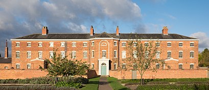
The Workhouse, Southwell Address: Upton Road Normanton Southwell NG25 0 street in Newark And Sherwood
Attractions near The Workhouse, Southwell
Ng25 0pt,Southwell Court Care Home,M&S Simply Food,M&S,Home 1st Physiotherapy,Elite Heat Plumbing and Heating,PN Locum,Puppy Producti,Southwell Children's House Day Nursery / Childcare,Reg Taylors Garden Centre,Gadsbys Bakery,K H Power,Red Key Marketing Limited,Heffernans Accountants,Webbsmart,Southwell Garden Centre Tea Rooms,Dial Hinde Associates,Reg Taylors Garden Centre Swan Sanctuary,Southwell Town Council,Arquero AppsHow to get to popular attractions in Newark And Sherwood with public transportation
E.ON (Bilborough), Nottingham,Lakeside Arts Centre, Nottingham,Riverside Retail Park, Northampton,Barlborough, Bolsover,Lidl, Peterborough,Hotel ibis Chesterfield Centre, Chesterfield,Tesco Extra, Leicester,Nettleham, West Lindsey,Bradgate Park & Swithland Wood Country Park, Charnwood,Southwell, Newark And Sherwood,Wyberton, Boston,Nottingham Station, Nottingham,Hilton Leicester Hotel, Blaby,Phoenix Park Tram Stop, Nottingham,Greenfield Medical Library, Nottingham,Queens Medical Centre, Nottingham,Steep Hill, Lincoln,Chequered Flag (Hungry Horse), Corby,Billing Aquadrome, Northampton,Western Park, LeicesterGet around Newark And Sherwood by public transport!
Travelling around Newark And Sherwood has never been so easy. See step by step directions as you travel to any attraction, street or major public transport station. View bus and train timetables, arrival times, service alerts and detailed routes on a map, so you know exactly how to get to anywhere in Newark And Sherwood.
When travelling to any destination around Newark And Sherwood use Moovit's Live Directions with Get Off Notifications to know exactly where and how far to walk, how long to wait for your line , and how many stops are left. Moovit will alert you when it’s time to get off — no need to constantly re-check whether yours is the next stop.
Wondering how to use public transport in Newark And Sherwood or how to pay for public transport in Newark And Sherwood? Moovit public transport app can help you navigate your way with public transport easily, and at minimum cost. It includes public transport fees, ticket prices, and costs. Looking for a map of Newark And Sherwood public transport lines? Moovit public transport app shows all public transport maps in Newark And Sherwood with all bus or train routes and stops on an interactive map.
Newark And Sherwood has 2 transport type(s), including: bus or train, operated by several transport agencies, including National Rail, Ashbourne Community Transport, Delaine Buses, Arriva Midlands, Centrebus, Our Centre, Hulleys of Baslow, D & G Bus, Stagecoach East Midlands, North Lincolnshire Council, National Rail, Roberts Coaches, Lawson's of Corby, Hawkes Coaches and East Yorkshire