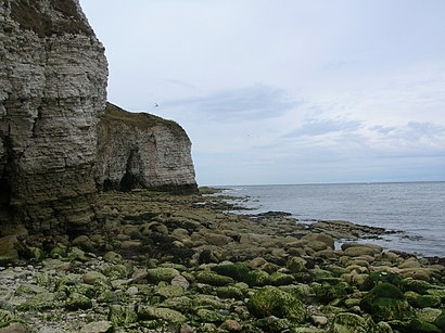
See Thornwick Bay, Flamborough, on the map
Directions to Thornwick Bay (Flamborough) with public transport
The following transport lines have routes that pass near Thornwick Bay
 Bus:
Bus:
How to get to Thornwick Bay by bus?
Click on the bus route to see step by step directions with maps, line arrival times and updated time schedules.
Bus stations near Thornwick Bay in Flamborough
- Flamborough Woodcock Rd,3 min walk,
- North Landing,9 min walk,
Bus lines to Thornwick Bay in Flamborough
- 14,Flamborough,
- 504,Flamborough,
What are the nearest stations to Thornwick Bay?
The nearest stations to Thornwick Bay are:
- Flamborough Woodcock Rd is 197 meters away, 3 min walk.
- North Landing is 682 meters away, 9 min walk.
Which bus line stops near Thornwick Bay?
14
What’s the nearest bus stop to Thornwick Bay in Flamborough?
The nearest bus stop to Thornwick Bay in Flamborough is Flamborough Woodcock Rd. It’s a 3 min walk away.
What time is the first bus to Thornwick Bay in Flamborough?
The 14 is the first bus that goes to Thornwick Bay in Flamborough. It stops nearby at 08:03.
What time is the last bus to Thornwick Bay in Flamborough?
The 14 is the last bus that goes to Thornwick Bay in Flamborough. It stops nearby at 18:14.
How much is the train fare to Thornwick Bay?
The train fare to Thornwick Bay costs about £4.00.
See Thornwick Bay, Flamborough, on the map
Public Transit to Thornwick Bay in Flamborough
Wondering how to get to Thornwick Bay in Flamborough, United Kingdom? Moovit helps you find the best way to get to Thornwick Bay with step-by-step directions from the nearest public transit station.
Moovit provides free maps and live directions to help you navigate through your city. View schedules, routes, timetables, and find out how long does it take to get to Thornwick Bay in real time.
Looking for the nearest stop or station to Thornwick Bay? Check out this list of stops closest to your destination: Flamborough Woodcock Rd; North Landing.
Bus:
Want to see if there’s another route that gets you there at an earlier time? Moovit helps you find alternative routes or times. Get directions from and directions to Thornwick Bay easily from the Moovit App or Website.
We make riding to Thornwick Bay easy, which is why over 1.5 million users, including users in Flamborough, trust Moovit as the best app for public transit. You don’t need to download an individual bus app or train app, Moovit is your all-in-one transit app that helps you find the best bus time or train time available.
For information on prices of bus and train, costs and ride fares to Thornwick Bay, please check the Moovit app.
Use the app to navigate to popular places including to the airport, hospital, stadium, grocery store, mall, coffee shop, school, college, and university.
Thornwick Bay Address: Thornwick Road Flamborough Bridlington YO15 1 street in Flamborough
Attractions near Thornwick Bay
Thornwick Bay Owners,North Landing Boat Tours and Fishing Trips,Costa Coffee,Megabites Take-Away,Thornwick Bay Holiday Village,Thornwick Bay (Flamborough),VendElectric,Yo15 1au,Thornwick Bay Holiday Village - Haven,Nightingale Cottage,Owl Cottage,Dove Cottage,Jenny Wren,Blackbird Cottage,Thornwick Bay and Sea Farm,North Landing, Flamborough,Barnsley Precious Metals,North Landing Car Park,The Caravel,Thornwick BayHow to get to popular attractions in Flamborough with public transportation
Valley Centertainment Tram Stop, Sheffield,Scarborough, Scarborough,Yorkshire Ambulance Service HQ, Wakefield,Bradford Royal Infirmary, Bradford,Chapel Allerton Hospital, Leeds,Clifton Green, York,Holiday Inn York, York,Asda, Morley,Tadcaster, Tadcaster,Beverley, Beverley,Sainsbury's Leeds Colton, Leeds,Cleckheaton, Heckmondwike,Odeon Luxe, Sheffield,Cottingley Towers, Leeds,Becketts Bank (Wetherspoon), Leeds,Supertram - Yellow Route: Meadowhall via City Centre to Middlewood, Sheffield,Hunter's Bar, Sheffield,St James's Hospital A&E, Leeds,Greenhead College, Huddersfield,Albion Street, LeedsGet around Flamborough by public transport!
Travelling around Flamborough has never been so easy. See step by step directions as you travel to any attraction, street or major public transport station. View bus and train timetables, arrival times, service alerts and detailed routes on a map, so you know exactly how to get to anywhere in Flamborough.
When travelling to any destination around Flamborough use Moovit's Live Directions with Get Off Notifications to know exactly where and how far to walk, how long to wait for your line , and how many stops are left. Moovit will alert you when it’s time to get off — no need to constantly re-check whether yours is the next stop.
Wondering how to use public transport in Flamborough or how to pay for public transport in Flamborough? Moovit public transport app can help you navigate your way with public transport easily, and at minimum cost. It includes public transport fees, ticket prices, and costs. Looking for a map of Flamborough public transport lines? Moovit public transport app shows all public transport maps in Flamborough with all bus or train routes and stops on an interactive map.
Flamborough has 2 transport type(s), including: bus or train, operated by several transport agencies, including First Leeds, First South Yorkshire, First York, First West Yorkshire Ltd, Arriva Yorkshire, Stagecoach Yorkshire, National Rail, First Bradford, First Halifax, Calder Valley & Huddersfield, East Yorkshire, The Keighley Bus Company, South Yorkshire Future Tram, The Harrogate Bus Company, National Rail and TM Travel