Directions to Wilford Village (Nottingham) with public transport
The following transport lines have routes that pass near Wilford Village
How to get to Wilford Village by bus?
Click on the bus route to see step by step directions with maps, line arrival times and updated time schedules.
How to get to Wilford Village by train?
Click on the train route to see step by step directions with maps, line arrival times and updated time schedules.
Light Rail stations near Wilford Village in Nottingham
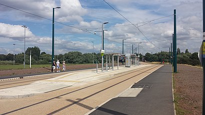
- Wilford Village Tram Stop, Wilford, 1 min walk,
Bus stops near Wilford Village in Nottingham
- Coronation Avenue, Wilford (Wi17), 2 min walk,
- Soudan Drive, Meadows (Me24), 7 min walk,
- Crossgate Drive, Queens Drive Industrial Estate (Me19), 10 min walk,
Bus lines to Wilford Village in Nottingham
- 3A, Nottingham,
- 48, Clifton,
- 48X, Clifton,
- 49, Nottingham,
- 49A, Nottingham,
- 49B, Queens Drive,
- 49X, Boots,
What are the nearest stations to Wilford Village?
The nearest stations to Wilford Village are:
- Wilford Village Tram Stop, Wilford is 10 meters away, 1 min walk.
- Coronation Avenue, Wilford (Wi17) is 145 meters away, 2 min walk.
- Soudan Drive, Meadows (Me24) is 471 meters away, 7 min walk.
- Crossgate Drive, Queens Drive Industrial Estate (Me19) is 738 meters away, 10 min walk.
Which bus lines stop near Wilford Village?
These bus lines stop near Wilford Village: 48, 48X, SKYLINK EXPRESS.
Which train lines stop near Wilford Village?
These train lines stop near Wilford Village: EAST MIDLANDS RAILWAY, NORTHERN.
Which light rail line stops near Wilford Village?
TRAM
What’s the nearest light rail station to Wilford Village in Nottingham?
The nearest light rail station to Wilford Village in Nottingham is Wilford Village Tram Stop, Wilford. It’s a 1 min walk away.
What’s the nearest bus stop to Wilford Village in Nottingham?
The nearest bus stop to Wilford Village in Nottingham is Coronation Avenue, Wilford (Wi17). It’s a 2 min walk away.
What time is the first light rail to Wilford Village in Nottingham?
The TRAM is the first light rail that goes to Wilford Village in Nottingham. It stops nearby at 05:30.
What time is the last light rail to Wilford Village in Nottingham?
The TRAM is the last light rail that goes to Wilford Village in Nottingham. It stops nearby at 00:05.
What time is the first bus to Wilford Village in Nottingham?
The 48X is the first bus that goes to Wilford Village in Nottingham. It stops nearby at 06:13.
What time is the last bus to Wilford Village in Nottingham?
The 48X is the last bus that goes to Wilford Village in Nottingham. It stops nearby at 00:14.
See Wilford Village, Nottingham, on the map
Public Transit to Wilford Village in Nottingham
Wondering how to get to Wilford Village in Nottingham, United Kingdom? Moovit helps you find the best way to get to Wilford Village with step-by-step directions from the nearest public transit station.
Moovit provides free maps and live directions to help you navigate through your city. View schedules, routes, timetables, and find out how long does it take to get to Wilford Village in real time.
Looking for the nearest stop or station to Wilford Village? Check out this list of stops closest to your destination: Wilford Village Tram Stop; Coronation Avenue; Soudan Drive; Crossgate Drive.
Bus: 48, 48X, SKYLINK EXPRESS, 3A, 49, 49A, 49B, 49X.Train: EAST MIDLANDS RAILWAY, NORTHERN.Light rail: TRAM.
Want to see if there’s another route that gets you there at an earlier time? Moovit helps you find alternative routes or times. Get directions from and directions to Wilford Village easily from the Moovit App or Website.
We make riding to Wilford Village easy, which is why over 1.5 million users, including users in Nottingham, trust Moovit as the best app for public transit. You don’t need to download an individual bus app or train app, Moovit is your all-in-one transit app that helps you find the best bus time or train time available.
For information on prices of bus, light rail and train, costs and ride fares to Wilford Village, please check the Moovit app.
Use the app to navigate to popular places including to the airport, hospital, stadium, grocery store, mall, coffee shop, school, college, and university.
Wilford Village Address: Coronation Avenue street in Nottingham
Attractions near Wilford Village
Nottingham Moderns Rfc,The Ferry Inn,Nottingham Moderns Rugby Club,Saint Wilfrid's Church, Nottingham,This Is Wilford,Ferry Inn,Wilford Village Garage Store,Nottingham Moderns Rfc,3 Store,Wills At Home,Cp Riverside School,Tottle Bakery,Wilford Playgroup,Pork Farms (Stop Li20),Wickes,Crossgate Drive (Stop Me10),Wilford,Procure Care Providers,Meadows Embankment,Trusted TechnologyHow to get to popular attractions in Nottingham with public transportation
Lincoln Road, Peterborough,Stagecoach X7 - Northampton to Leicester Bus, Northampton,Osmaston Park Sainsbury's, Derby,RAF Wittering, Peterborough,National Express Ticket Office, Nottingham,Derby County Football Club, Derby,Chester Green, Derby,Showcase Cinemas, Nottingham,The City Ground, Rushcliffe,MORRISONS (Morrisons Leicester), Leicester,M69 Junction 1 / A5, Hinckley And Bosworth,Newtown Linford, Charnwood,Bruntingthorpe, Harborough,Dave Eastwood Sports Ground (Pelican Colts Fc), Nottingham,Adrenaline Alley, Corby,Erotic Massage, Anna, Nottingham,Hollywood Bowl, Peterborough,Wilkinson Street Tram Stop, Nottingham,St James Retail Park, Northampton,Red Kangaroo, NottinghamGet around East Midlands by public transport!
Travelling around East Midlands has never been so easy. See step by step directions as you travel to any attraction, street or major public transport station. View bus and train timetables, arrival times, service alerts and detailed routes on a map, so you know exactly how to get to anywhere in East Midlands.
When travelling to any destination around East Midlands use Moovit's Live Directions with Get Off Notifications to know exactly where and how far to walk, how long to wait for your line , and how many stops are left. Moovit will alert you when it’s time to get off — no need to constantly re-check whether yours is the next stop.
Wondering how to use public transport in East Midlands or how to pay for public transport in East Midlands? Moovit public transport app can help you navigate your way with public transport easily, and at minimum cost. It includes public transport fees, ticket prices, and costs. Looking for a map of East Midlands public transport lines? Moovit public transport app shows all public transport maps in East Midlands with all Bus, Train and Light rail routes and stops on an interactive map.
East Midlands has 3 transport type(s), including: Bus, Train and Light rail, operated by several transport agencies, including National Rail, Ashbourne Community Transport, Delaine Buses, Arriva Midlands, Centrebus, Our Centre, Hulleys of Baslow, D & G Bus, Stagecoach East Midlands, North Lincolnshire Council, Roberts Coaches, Lawson's of Corby, Hawkes Coaches, East Yorkshire, Soar Valley Community Bus