See Woodstock, Burwood, Burwood (NSW), on the map
Directions to Woodstock, Burwood (Burwood (NSW)) with public transport
The following transport lines have routes that pass near Woodstock, Burwood
 Bus:
Bus: - Train:
How to get to Woodstock, Burwood by bus?
Click on the bus route to see step by step directions with maps, line arrival times and updated time schedules.
How to get to Woodstock, Burwood by train?
Click on the train route to see step by step directions with maps, line arrival times and updated time schedules.
Bus stations near Woodstock, Burwood in Burwood (NSW)
- Burwood Rd at Livingstone St,2 min walk,
- Burwood Rd at Duff St,3 min walk,
- Club Burwood RSL, Clarence St,4 min walk,
- Burwood Rd at Minna St,4 min walk,
- Fitzroy St at Weldon St,5 min walk,
- Fitzroy St after Shaftesbury Rd,5 min walk,
Train stations near Woodstock, Burwood in Burwood (NSW)
- Strathfield Station,4 min walk,
Bus lines to Woodstock, Burwood in Burwood (NSW)
- 418,Burwood Westfield,
- 464,Burwood Stn (Burwood Rd),
- 466,Broadway Enfield,
- 588S,St. Patricks Strathfield,
- 780S,Homebush Boys High,
- 490,Hurstville Station, Mcmahon St, Sta,
- 492,Scalabrini Village,
- 587S,Burwood Station (Railway Pde),
- 743S,Burwood Girls High,
- 576S,Earlwood Shops - Homer St,
What are the nearest stations to Woodstock, Burwood?
The nearest stations to Woodstock, Burwood are:
- Burwood Rd at Livingstone St is 30 meters away, 2 min walk.
- Burwood Rd at Duff St is 179 meters away, 3 min walk.
- Club Burwood RSL, Clarence St is 218 meters away, 4 min walk.
- Burwood Rd at Minna St is 253 meters away, 4 min walk.
- Fitzroy St at Weldon St is 270 meters away, 5 min walk.
- Strathfield Station is 280 meters away, 4 min walk.
- Fitzroy St after Shaftesbury Rd is 287 meters away, 5 min walk.
Which bus lines stop near Woodstock, Burwood?
These bus lines stop near Woodstock, Burwood: 418, 464, 490, 492.
Which train lines stop near Woodstock, Burwood?
These train lines stop near Woodstock, Burwood: T2, T9.
What’s the nearest train station to Woodstock, Burwood in Burwood (NSW)?
The nearest train station to Woodstock, Burwood in Burwood (NSW) is Strathfield Station. It’s a 4 min walk away.
What’s the nearest bus stop to Woodstock, Burwood in Burwood (NSW)?
The nearest bus stop to Woodstock, Burwood in Burwood (NSW) is Burwood Rd at Livingstone St. It’s a 2 min walk away.
What time is the first train to Woodstock, Burwood in Burwood (NSW)?
The CCN is the first train that goes to Woodstock, Burwood in Burwood (NSW). It stops nearby at 03:58.
What time is the last train to Woodstock, Burwood in Burwood (NSW)?
The 34 is the last train that goes to Woodstock, Burwood in Burwood (NSW). It stops nearby at 06:29.
What time is the first bus to Woodstock, Burwood in Burwood (NSW)?
The 464 is the first bus that goes to Woodstock, Burwood in Burwood (NSW). It stops nearby at 04:54.
What time is the last bus to Woodstock, Burwood in Burwood (NSW)?
The 464 is the last bus that goes to Woodstock, Burwood in Burwood (NSW). It stops nearby at 00:19.
How much is the train fare to Woodstock, Burwood?
The train fare to Woodstock, Burwood costs about $2.56 - $6.99.
How much is the light rail fare to Woodstock, Burwood?
The light rail fare to Woodstock, Burwood costs about $2.24 - $4.87.
How much is the metro fare to Woodstock, Burwood?
The metro fare to Woodstock, Burwood costs about $2.56 - $6.99.
How much is the bus fare to Woodstock, Burwood?
The bus fare to Woodstock, Burwood costs about $2.24 - $4.87.
See Woodstock, Burwood, Burwood (NSW), on the map
Public Transit to Woodstock, Burwood in Burwood (NSW)
Wondering how to get to Woodstock, Burwood in Burwood (NSW), Australia? Moovit helps you find the best way to get to Woodstock, Burwood with step-by-step directions from the nearest public transit station.
Moovit provides free maps and live directions to help you navigate through your city. View schedules, routes, timetables, and find out how long does it take to get to Woodstock, Burwood in real time.
Looking for the nearest stop or station to Woodstock, Burwood? Check out this list of stops closest to your destination: Burwood Rd at Livingstone St; Burwood Rd at Duff St; Club Burwood RSL; Burwood Rd at Minna St; Fitzroy St at Weldon St; Strathfield Station; Fitzroy St after Shaftesbury Rd.
Bus:Train:
Want to see if there’s another route that gets you there at an earlier time? Moovit helps you find alternative routes or times. Get directions from and directions to Woodstock, Burwood easily from the Moovit App or Website.
We make riding to Woodstock, Burwood easy, which is why over 1.5 million users, including users in Burwood (NSW), trust Moovit as the best app for public transit. You don’t need to download an individual bus app or train app, Moovit is your all-in-one transit app that helps you find the best bus time or train time available.
For information on prices of bus, train, light rail and metro, costs and ride fares to Woodstock, Burwood, please check the Moovit app.
Use the app to navigate to popular places including to the airport, hospital, stadium, grocery store, mall, coffee shop, school, college, and university.
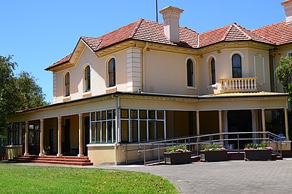
Woodstock, Burwood Address: 22 Church St street in Burwood (NSW)
Attractions near Woodstock, Burwood
Woodstock, Burwood,Woodstock Community Centre,Fitzroy Hall,Association of Blind Citizens of NSW,Proven Pest Control,Dr. N. Rahme,Burwood Rd at Duff St,The Cortese-Zborowska Family Trust,Burwood Road Montessori Academy,Bupuma,Impulse Products,LJ Hair Group,St Paul's Anglican Church,Burwood Church of Christ,Dr Naomi Napper,DJ Dumplings,Dr E Brumby,Clocktower Medical Practice,K Galaxy,PhysiochiroHow to get to popular attractions in Burwood (NSW) with public transportation
Wynyard, Sydney,Westfield Miranda, Miranda (NSW),Ms. G's, Potts Point,Charlestown Square Shopping Centre, Charlestown (NSW),The Orient Hotel, The Rocks (Sydney - NSW),Parramatta, Parramatta,Crowne Plaza, Coogee (NSW),University Of Newcastle (Callaghan Campus), Callaghan,St Vincents Hospital, Darlinghurst,Riverwood Station, Riverwood,Broadway Shopping Centre, Glebe (NSW),Watsons Bay, Watsons Bay,Single O, Surry Hills,Westfield Hurstville, Hurstville,Lewisham Station, Lewisham (NSW),Artarmon Station (Platform 2), Artarmon,MarketPlace Leichhardt, Leichhardt (NSW),Helm Bar, Sydney,Katoomba Station, Katoomba,Dove & Olive Hotel, Surry HillsGet around Burwood (NSW) by public transport!
Travelling around Burwood (NSW) has never been so easy. See step by step directions as you travel to any attraction, street or major public transport station. View bus and train timetables, arrival times, service alerts and detailed routes on a map, so you know exactly how to get to anywhere in Burwood (NSW).
When travelling to any destination around Burwood (NSW) use Moovit's Live Directions with Get Off Notifications to know exactly where and how far to walk, how long to wait for your line , and how many stops are left. Moovit will alert you when it’s time to get off — no need to constantly re-check whether yours is the next stop.
Wondering how to use public transport in Burwood (NSW) or how to pay for public transport in Burwood (NSW)? Moovit public transport app can help you navigate your way with public transport easily, and at minimum cost. It includes public transport fees, ticket prices, and costs. Looking for a map of Burwood (NSW) public transport lines? Moovit public transport app shows all public transport maps in Burwood (NSW) with all bus, train, light rail or metro routes and stops on an interactive map.
Burwood (NSW) has 4 transport type(s), including: bus, train, light rail or metro, operated by several transport agencies, including Sydney Metro, Sydney Trains, Sydney Light Rail, Sydney Ferries, Intercity Trains, Intercity Train, NSW TrainLink, CDC NSW R14, U-Go Mobility, Keolis Downer Northern Beaches, Manly Fast Ferry, Transdev John Holland Buses, Busways, Busways North West and Dysons Buslines