N10 Line
Sutherland to City Town Hall (Night Service)
U-Go Mobility
U-Go Mobility N10 Bus Route Schedule and Stops (Updated)
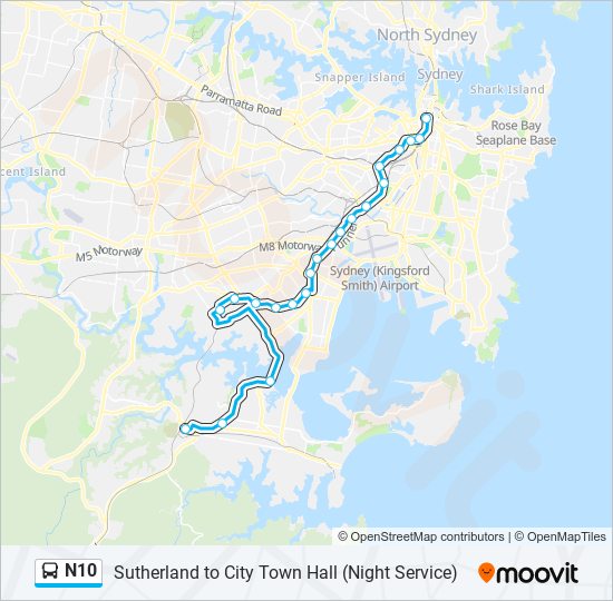
The N10 bus (Sutherland Station) has 21 stops departing from Town Hall, Park St, Stand H and ending at Sutherland Station, Flora St, Stand F.
Choose any of the N10 bus stops below to find updated real-time schedules and to see their route map.
Direction: Sutherland Station (21 stops)
Town Hall, Park St, Stand H
Central Station, Railway Square, Stand M
Broadway at Buckland St
University of Sydney, City Rd
Newtown Station, King St, Stand D
King St opp St Peters Station
Princes Hwy opp Railway Rd
Princes Hwy at Fanning St
Cahill Park, Princes Hwy
Princes Hwy at Kyle St
Banksia Station, Railway St
Rockdale Station, Railway St, Stand G
Kogarah Station, Regent St, Stand D
Railway Pde opp Carlton Station
Railway Pde opp Allawah Station
Hurstville Station, Ormonde Pde, Stand L
Penshurst Station, Bridge St
Mortdale Station, Pitt St, Stand B
Princes Hwy opp Clare St
Gymea Technology High School, Princes Hwy
Sutherland Station, Flora St, Stand F
N10 FAQ
What time does the N10 bus start operating?
Services on the N10 bus start at 01:00 on Sunday, Monday, Tuesday, Wednesday, Thursday, Friday, Saturday.
What time does the N10 bus stop working?
Services on the N10 bus stop at 04:00 on Sunday, Monday, Tuesday, Wednesday, Thursday, Friday, Saturday.
What time does the N10 bus arrive?
When does the Sutherland to City Town Hall (Night Service) bus line come? Check Live Arrival Times for live arrival times and to see the full schedule for the Sutherland to City Town Hall (Night Service) bus line that is closest to your location.
Is there a N10 bus stop near me?
Click here to view the nearest N10 bus stop.
U-Go Mobility Bus Service Alerts
See all updates on N10 (from Town Hall, Park St, Stand H), including real-time status info, bus delays, changes of routes, changes of stops locations, and any other service changes. Get a real-time map view of N10 (Sutherland Station) and track the bus as it moves on the map. Download the app for all U-Go Mobility info now.
N10 line bus fare
U-Go Mobility N10 (Sutherland Station) prices may change based on several factors. For more information about U-Go Mobility tickets costs please check the Moovit app or U-Go Mobility’s official website.

N10 (U-Go Mobility)
The first stop of the N10 bus route is Town Hall, Park St, Stand H and the last stop is Sutherland Station, Flora St, Stand F. N10 (Sutherland Station) is operational during everyday.
Additional information: N10 has 21 stops and the total trip duration for this route is approximately 62 minutes.
On the go? See why over 1.5 million users trust Moovit as the best public transport app. Moovit gives you U-Go Mobility suggested routes, real-time bus tracker, live directions, line route maps in Sydney, and helps to find the closest N10 bus stops near you. No internet available? Download an offline PDF map and bus schedule for the N10 bus to take on your trip.
Line N10 Real Time bus Tracker
Track line N10 (Sutherland Station) on a live map in real time and follow its location as it moves between stations. Use Moovit as a line N10 bus tracker or a live U-Go Mobility bus tracker app and never miss your bus.
Use the app as a trip planner for U-Go Mobility or a trip planner for metro, train, light rail, ferry or bus to plan your route around Sydney. The trip planner shows updated data for U-Go Mobility and any bus, including line N10, in Sydney
N10 - Alternative Directions
U-Go Mobility Lines in Sydney
- S325 - St Patricks College to Oyster Bay/ Timetable
- S042 - Kirrawee HS to Gymea Bay PS/ Timetable
- 455 - Kingsgrove to St George Hospital, Kogarah/ Timetable
- S14 - Lakemba to Mount Lewis via Roselands/ Timetable
- S063 - Bundanoon Rd at Lowry Pl, Woronora Heights to St John Bosco College/ Timetable
- S040 - Sutherland Interchange to Inaburra School/ Timetable
- S706 - Sutherland Public School to Kirrawee/ Timetable
- S015 - Sutherland Station to Garnet Rd after Ruby Rd, Gymea/ Timetable
- 986 - Miranda North to Miranda/ Timetable
- 962 - East Hills to Miranda/ Timetable
- S148 - Mt St Joseph Secondary to Gibson Avenue after Turvey St, Padstow/ Timetable
- S319 - Forest Rd before Premier St, Gymea to Kirrawee HS via Gymea Bay/ Timetable
- 2C - Woolooware HS to Saunders Bay Rd after Parthenia St, Caringbah South/ Timetable
- S244 - Sutherland Station to Kirrawee HS/ Timetable
- S193 - Georges River Grammar to Revesby Station via East Hills Station/ Timetable
- S228 - Myrtle St at Spur Cres, Loftus to St John Bosco PS/ Timetable
- S740 - Georges River Grammar to Padstow Heights/ Timetable
- 942 - Lugarno to Campsie/ Timetable
- S15 - Endeavour Sports HS to Woolooware HS via Caringbah Station/ Timetable
- S735 - Mt St Joseph School to Revesby Heights/ Timetable
