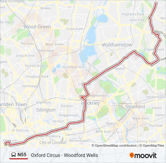
N55 Line
Oxford Circus - Woodford Wells
London Buses
London Buses N55 Bus Route Schedule and Stops (Updated)
The N55 bus (Woodford Wells) has 75 stops departing from Holles Street (OG) and ending at St.Thomas Of Canterbury Church (Fh).
Choose any of the N55 bus stops below to find updated real-time schedules and to see their route map.
Direction: Woodford Wells (75 stops)
Holles Street (OG)
Great Titchfield St / Oxford Circus Stn (OJ)
Tottenham Court Road Station (V)
Tottenham Ct Rd Stn / New Oxford St (Y)
Museum Street (E)
Bloomsbury Square (F)
Red Lion Street (G)
Gray's Inn Road (CA)
Rosebery Avenue (CU)
Farringdon Road (E)
St John Street (J)
Goswell Road (BS)
Central Street (BZ)
St Luke's Music Education Centre (J)
Old Street Station (F)
Great Eastern Street (Y)
Shoreditch Town Hall (X)
Hackney Road / Columbia Road (R)
Hoxton Station (HG)
Queensbridge Road (HH)
Warner Place (HJ)
Pritchards Road (HK)
Cambridge Heath Station (O)
Mare Street / Victoria Park Road (R)
King Edward's Road (LP)
Mare Street / Well Street (LC)
St Thomas's Square (LQ)
Hackney Town Hall (A)
Hackney Central Station (J)
Amhurst Road / Hackney Downs Station (L)
Mare Street / Narrow Way (R)
Hackney Baths (U)
Glenarm Road (Z)
Clapton Girls' Academy (L)
Clapton Pond (H)
Lea Bridge Roundabout (L)
Lea Bridge Road / Upper Clapton Road (S)
Chatsworth Road (V)
Lee Valley Ice Centre (W)
Lee Valley Riding Centre (X)
Perth Road (LE)
Emmanuel Parish Church (LF)
Markhouse Road (LG)
Rochdale Road (LH)
Shrubland Road (EA)
High Road Leyton / Bakers Arms (EC)
Lea Bridge Road / Bakers Arms (EH)
Leyton Green Road (Ej)
Shernhall Street (Ek)
Peterborough Rd Lea Bridge Rd (El)
Whipps Cross Wood Street (A)
Whipps Cross Bus Stand (V)
Whipps Cross Hospital (E)
James Lane (T)
Sir Alfred Hitchcock Hotel (S)
Leyton Way (PP)
Cambridge Road (H)
Blake Hall Road (K)
Wanstead (B)
Wanstead Place (SH)
New Wanstead (SU)
Sylvan Road (SV)
Heronwood Hospital (SW)
Charnwood Drive (T)
George Lane / Chigwell Road (Z)
South Woodford Station (E)
George Lane Shopping Centre (H)
Southend Road (L)
Chelmsford Road (X)
Empress Avenue (Y)
Churchill Memorial (Z)
Chingford Lane (S)
Woodford Green Broadmead Rd (U)
Monkhams Lane (V)
St.Thomas Of Canterbury Church (Fh)
N55 FAQ
What time does the N55 bus start operating?
Services on the N55 bus start at 03:10 on Monday, Tuesday, Wednesday, Thursday, Friday.
What time does the N55 bus stop working?
Services on the N55 bus stop at 02:40 on Sunday, Monday, Tuesday, Wednesday, Thursday.
What time does the N55 bus arrive?
When does the Oxford Circus - Woodford Wells bus line come? Check Live Arrival Times for live arrival times and to see the full schedule for the Oxford Circus - Woodford Wells bus line that is closest to your location.
Is there a N55 bus stop near me?
Click here to view the nearest N55 bus stop.
London Buses Service Alerts
See all updates on N55 (from Holles Street (OG)), including real-time status info, bus delays, changes of routes, changes of stops locations, and any other service changes. Get a real-time map view of N55 (Woodford Wells) and track the bus as it moves on the map. Download the app for all London Buses info now.
N55 line bus fare
London Buses N55 (Woodford Wells) prices may change based on several factors. For more information about London Buses tickets costs please check the Moovit app or London Buses’s official website.

N55 (London Buses)
The first stop of the N55 bus route is Holles Street (OG) and the last stop is St.Thomas Of Canterbury Church (Fh). N55 (Woodford Wells) is operational during everyday.
Additional information: N55 has 75 stops and the total trip duration for this route is approximately 70 minutes.
On the go? See why over 1.5 million users trust Moovit as the best public transport app. Moovit gives you London Buses suggested routes, real-time bus tracker, live directions, line route maps in London, and helps to find the closest N55 bus stops near you. No internet available? Download an offline PDF map and bus schedule for the N55 bus to take on your trip.
Line N55 Real Time bus Tracker
Track line N55 (Woodford Wells) on a live map in real time and follow its location as it moves between stations. Use Moovit as a line N55 bus tracker or a live London Buses bus tracker app and never miss your bus.
Use the app as a trip planner for London Buses or a trip planner for Tube, bus, DLR, Tramlink, train or River Bus to plan your route around London. The trip planner shows updated data for London Buses and any bus, including line N55, in London
N55 - Alternative Directions
London Buses Lines in London
- E11 - Ealing, Warwick Dene - Greenford Broadway/ Timetable
- C3 - Earl's Court, Tesco - Fulham, Sands End/ Timetable
- 329 - Wood Green - Enfield/ Timetable
- 376 - East Ham, Newham Town Hall - Beckton Station/ Timetable
- B14 - Orpington Station - Bexleyheath, Shopping Centre/ Timetable
- N155 - Aldwych - Morden/ Timetable
- 83 - Alperton, Sainsbury's - Golders Green/ Timetable
- 100 - Shadwell - St Paul's/ Timetable
- 268 - Finchley Road, O2 Centre - Golders Green/ Timetable
- SL1 - Walthamstow Central - North Finchley/ Timetable
- 218 - North Acton - Hammersmith/ Timetable
- 46 - Bart's Hospital - Paddington/ Timetable
- N271 - Moorgate, Finsbury Square - North Finchley/ Timetable
- 201 - Herne Hill - Morden/ Timetable
- 49 - White City - Clapham Junction/ Timetable
- 642 - London Academy - West Hendon Broadway/ Timetable
- 101 - Beckton Station - Wanstead/ Timetable
- W14 - Leyton, Superstores - Woodford Bridge/ Timetable
- R5 - Green Street Green - Orpington Station/ Timetable
- G1 - Battersea, Shaftesbury Estate - Streatham, Green Lane/ Timetable
