Directions to ステーションガーデンタワー (北区) with public transportation
The following transit lines have routes that pass near ステーションガーデンタワー
How to get to ステーションガーデンタワー by bus?
Click on the bus route to see step by step directions with maps, line arrival times and updated time schedules.
Metro stations near ステーションガーデンタワー in 北区
- 西日暮里 Nishi-Nippori, 7 min walk,
- 日暮里 Nippori, 10 min walk,
What are the closest stations to ステーションガーデンタワー?
The closest stations to ステーションガーデンタワー are:
- 西日暮里 Nishi-Nippori is 456 meters away, 7 min walk.
- 日暮里 Nippori is 705 meters away, 10 min walk.
Which bus lines stop near ステーションガーデンタワー?
These bus lines stop near ステーションガーデンタワー: 上58, 都08(T08), 里22.
What’s the nearest metro station to ステーションガーデンタワー in 北区?
The nearest metro station to ステーションガーデンタワー in 北区 is 西日暮里 Nishi-Nippori. It’s a 7 min walk away.
What time is the first bus to ステーションガーデンタワー in 北区?
The 草63 is the first bus that goes to ステーションガーデンタワー in 北区. It stops nearby at 6:21 AM.
What time is the last bus to ステーションガーデンタワー in 北区?
The 草63 is the last bus that goes to ステーションガーデンタワー in 北区. It stops nearby at 10:28 PM.
See ステーションガーデンタワー, 北区, on the map
Public Transit to ステーションガーデンタワー in 北区
Wondering how to get to ステーションガーデンタワー in 北区, Japan? Moovit helps you find the best way to get to ステーションガーデンタワー with step-by-step directions from the nearest public transit station.
Moovit provides free maps and live directions to help you navigate through your city. View schedules, routes, timetables, and find out how long does it take to get to ステーションガーデンタワー in real time.
Looking for the nearest stop or station to ステーションガーデンタワー? Check out this list of stops closest to your destination: 西日暮里 Nishi-Nippori; 日暮里 Nippori.
Bus: 上58, 都08(T08), 里22.Metro: 京浜東北線・根岸線 KEIHIN-TOHOKU-NEGISHI LINE, 千代田線 CHIYODA LINE, 山手線 YAMANOTE LINE, 日暮里・舎人ライナー NIPPORI-TONERI LINER, 常磐線快速 JOBAN RAPID LINE.
Want to see if there’s another route that gets you there at an earlier time? Moovit helps you find alternative routes or times. Get directions from and directions to ステーションガーデンタワー easily from the Moovit App or Website.
We make riding to ステーションガーデンタワー easy, which is why over 1.5 million users, including users in 北区, trust Moovit as the best app for public transit. You don’t need to download an individual bus app or train app, Moovit is your all-in-one transit app that helps you find the best bus time or train time available.
For information on prices of bus, costs and ride fares to ステーションガーデンタワー, please check the Moovit app.
Use the app to navigate to popular places including to the airport, hospital, stadium, grocery store, mall, coffee shop, school, college, and university.
ステーションガーデンタワー Address: 尾久橋通り street in 北区
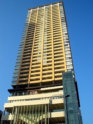
The Station Garden Tower (サンマークシティ日暮里ステーションガーデンタワー) is a mixed-use building in the Arakawa special ward of Tokyo, Japan. Completed in April 2008, it stands at 153 m (502 ft) tall.Wiki
Attractions near ステーションガーデンタワー
太陽歯科衛生士専門学校,セブン-イレブン,日暮里駅前郵便局,一由そば,ピタットハウス,ホテル・エル,ホテルたかしま,ステーション日暮里,日暮里レディースクリニック,セブン-イレブン,さくら水産 日暮里北口店,六文そば 日暮里第1号店,アルファモバイル,ミキ薬局,西日暮里二丁目,立ち呑み 呑べえ,Hamburg Train (ハンバーグトレイン),麺や葵 日暮里駅前店,マルマンストア,噂のこの串かつあのおでんHow to get to popular attractions in 北区 with public transit
根津美術館, 渋谷区,山村学園高等学校野田グラウンド, 川越市,深海魚, 新宿区,セント メリーズ インターナショナル スクール, 世田谷区,竹の塚警察署, 足立区,増上寺, 港区,新相鉄ビル, 横浜市,鶴見大学 師岡グラウンド, 横浜市,1000 Club, 横浜市,佐川急便研修センター自動車教習所,埼玉県済生会川口総合病院, 川口市,慶應義塾大学 三田キャンパス 第一校舎, 港区,A Team Academy (エーチームアカデミー), 川崎市,Ariake Garden (有明ガーデン), 江東区,妙見島, 江戸川区,池袋ミカド劇場, 豊島区,埼玉県立芸術総合高等学校, 所沢市,大成建設株式会社 技術センター, 横浜市,品川区立 伊藤学園, 品川区,黒茶屋, あきる野市Get around Tokyo by public transit!
Traveling around Tokyo has never been so easy. See step by step directions as you travel to any attraction, street or major public transit station. View bus and train schedules, arrival times, service alerts and detailed routes on a map, so you know exactly how to get to anywhere in Tokyo.
When traveling to any destination around Tokyo use Moovit's Live Directions with Get Off Notifications to know exactly where and how far to walk, how long to wait for your line, and how many stops are left. Moovit will alert you when it's time to get off — no need to constantly re-check whether yours is the next stop.
Wondering how to use public transit in Tokyo or how to pay for public transit in Tokyo? Moovit public transit app can help you navigate your way with public transit easily, and at minimum cost. It includes public transit fees, ticket prices, and costs. Looking for a map of Tokyo public transit lines? Moovit public transit app shows all public transit maps in Tokyo with all Bus and Metro routes and stops on an interactive map.
Tokyo has 2 transit type(s), including: Bus and Metro, operated by several transit agencies, including JR East, Tokyo Metro, Toei, Tokyo Waterfront Area Rapid Transit, Transportation Bureau, City of Yokohama, Sagami Railway, 都営バス, Kokusai Kogyo Bus, Tokyu Bus, Keio Bus, Kanto Bus, Nishi Tokyo Bus, Sotetsu Bus