Directions to 元加治 (飯能市) with public transportation
The following transit lines have routes that pass near 元加治
How to get to 元加治 by bus?
Click on the bus route to see step by step directions with maps, line arrival times and updated time schedules.
How to get to 元加治 by metro?
Click on the metro route to see step by step directions with maps, line arrival times and updated time schedules.
Metro stations near 元加治 in 飯能市
- 東飯能 Higashi-Hanno, 51 min walk,
What are the closest stations to 元加治?
The closest stations to 元加治 are:
- 東飯能 Higashi-Hanno is 3953 meters away, 51 min walk.
Which bus lines stop near 元加治?
These bus lines stop near 元加治: 飯07, 飯11.
Which metro line stops near 元加治?
八高線 HACHIKO LINE
What time is the first metro to 元加治 in 飯能市?
The 八高線 HACHIKO LINE is the first metro that goes to 元加治 in 飯能市. It stops nearby at 5:14 AM.
What time is the last metro to 元加治 in 飯能市?
The 八高線 HACHIKO LINE is the last metro that goes to 元加治 in 飯能市. It stops nearby at 11:57 PM.
See 元加治, 飯能市, on the map
Public Transit to 元加治 in 飯能市
Wondering how to get to 元加治 in 飯能市, Japan? Moovit helps you find the best way to get to 元加治 with step-by-step directions from the nearest public transit station.
Moovit provides free maps and live directions to help you navigate through your city. View schedules, routes, timetables, and find out how long does it take to get to 元加治 in real time.
Looking for the nearest stop or station to 元加治? Check out this list of stops closest to your destination: 東飯能 Higashi-Hanno.
Bus: 飯07, 飯11.Metro: 八高線 HACHIKO LINE.
Want to see if there’s another route that gets you there at an earlier time? Moovit helps you find alternative routes or times. Get directions from and directions to 元加治 easily from the Moovit App or Website.
We make riding to 元加治 easy, which is why over 1.5 million users, including users in 飯能市, trust Moovit as the best app for public transit. You don’t need to download an individual bus app or train app, Moovit is your all-in-one transit app that helps you find the best bus time or train time available.
For information on prices of metro and bus, costs and ride fares to 元加治, please check the Moovit app.
Use the app to navigate to popular places including to the airport, hospital, stadium, grocery store, mall, coffee shop, school, college, and university.
Location: 飯能市, Tokyo
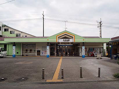
Motokaji Station (元加治駅, Motokaji-eki) is a passenger railway station located in the city of Iruma, Saitama, Japan, operated by the private railway operator Seibu Railway.Wiki
Attractions near 元加治
飯能自動車学校,旧西武町役場庁舎,アベイル,あいわ広場,Tsutaya 入間仏子店,どんぐりの会 入口,フロンティアタワーズ(学生寮),カフェ&レストラン ホットポット,あけぼのこどもの森公園,入間チャペル,国民宿舎 入間グリーンロッジ跡(廃墟),上野公会堂,私立武蔵野音楽大学附属高等学校,武蔵野音楽大学武蔵野幼稚園,駿河台大学,入間市立図書館西武分館,椿本チエイン,入間仏子団地8号棟,ライオンズマンション仏子1号棟,仏子第二公園How to get to popular attractions in 飯能市 with public transit
池袋駅 C6出口, 豊島区,くまみちモールあさか, 朝霞市,アミューズメントパークベネクス, 川崎市,Shibuya WWW X, 渋谷区,桃李(とうり), 豊島区,大森西区民センター, 大田区,赤坂区民センター, 新宿区,かねだい 青梅店, 青梅市,ハローワーク飯田橋 合同庁舎, 文京区,新宿駅西口 都庁大型バス駐車場, 中野区,JFEスチール 東日本製鉄所 扇島正門, 川崎市,舞岡公園, 横浜市,舎人公園, 足立区,東京都立 白鴎高等学校 附属中学校, 台東区,武南警察署, 鳩ヶ谷市,さいたま地方裁判所, さいたま市,瀬上市民の森, 横浜市,並木橋交差点, 渋谷区,東京都網代ホームきずな, あきる野市,昭和大学病院, 品川区Get around Tokyo by public transit!
Traveling around Tokyo has never been so easy. See step by step directions as you travel to any attraction, street or major public transit station. View bus and train schedules, arrival times, service alerts and detailed routes on a map, so you know exactly how to get to anywhere in Tokyo.
When traveling to any destination around Tokyo use Moovit's Live Directions with Get Off Notifications to know exactly where and how far to walk, how long to wait for your line, and how many stops are left. Moovit will alert you when it's time to get off — no need to constantly re-check whether yours is the next stop.
Wondering how to use public transit in Tokyo or how to pay for public transit in Tokyo? Moovit public transit app can help you navigate your way with public transit easily, and at minimum cost. It includes public transit fees, ticket prices, and costs. Looking for a map of Tokyo public transit lines? Moovit public transit app shows all public transit maps in Tokyo with all Bus and Metro routes and stops on an interactive map.
Tokyo has 2 transit type(s), including: Bus and Metro, operated by several transit agencies, including JR East, Tokyo Metro, Toei, Tokyo Waterfront Area Rapid Transit, Transportation Bureau, City of Yokohama, Sagami Railway, 都営バス, Kokusai Kogyo Bus, Tokyu Bus, Keio Bus, Kanto Bus, Nishi Tokyo Bus, Sotetsu Bus