Directions to 光明大街 (光明街道) with public transportation
The following transit lines have routes that pass near 光明大街
How to get to 光明大街 by bus?
Click on the bus route to see step by step directions with maps, line arrival times and updated time schedules.
How to get to 光明大街 by metro?
Click on the metro route to see step by step directions with maps, line arrival times and updated time schedules.
Bus stops near 光明大街 in 光明街道
- 光明油站, 1 min walk,
- 光明社保分局, 5 min walk,
- 滨河苑, 8 min walk,
- 华夏二路路口, 23 min walk,
Metro station near 光明大街 in 光明街道
- 光明大街, 9 min walk,
Bus lines to 光明大街 in 光明街道
- 301, 迳口村路口,
- 325, 皇岗口岸,
- 720, 光明新区中心医院,
- 325B, 光明圳美总站,
- E15, 光明总站,
- M436, 凤凰村总站,
- M206, 深圳湾口岸 - 东周总站,
- M411, 根竹园总站 - 东周总站,
- M462, 深圳北站 - 东周总站,
- 机场5线, 机场新航站楼 - 光明城站,
- B660, 迳口新村,
- B662, 光明医院总站,
- B722, 光明迳口村,
- B873, 光明城站总站,
- E19, 公明马山头总站,
- E28, 福田高铁站,
- M215-M218, 马山头公交总站,
- B659, 光明大道换乘站,
What are the closest stations to 光明大街?
The closest stations to 光明大街 are:
- 光明油站 is 37 meters away, 1 min walk.
- 光明社保分局 is 315 meters away, 5 min walk.
- 滨河苑 is 567 meters away, 8 min walk.
- 光明大街 is 670 meters away, 9 min walk.
- 华夏二路路口 is 1771 meters away, 23 min walk.
Which bus lines stop near 光明大街?
These bus lines stop near 光明大街: 325B, 720, B722, E15, M436, M462.
Which metro line stops near 光明大街?
6号线 (科学馆)
What’s the nearest metro station to 光明大街 in 光明街道?
The nearest metro station to 光明大街 in 光明街道 is 光明大街. It’s a 9 min walk away.
What’s the nearest bus station to 光明大街 in 光明街道?
The nearest bus station to 光明大街 in 光明街道 is 光明油站. It’s a 1 min walk away.
What time is the first metro to 光明大街 in 光明街道?
The 6号线 is the first metro that goes to 光明大街 in 光明街道. It stops nearby at 6:37 AM.
What time is the last metro to 光明大街 in 光明街道?
The 6号线 is the last metro that goes to 光明大街 in 光明街道. It stops nearby at 11:52 PM.
What time is the first bus to 光明大街 in 光明街道?
The M206 is the first bus that goes to 光明大街 in 光明街道. It stops nearby at 6:00 AM.
What time is the last bus to 光明大街 in 光明街道?
The 325 is the last bus that goes to 光明大街 in 光明街道. It stops nearby at 12:21 AM.
See 光明大街, 光明街道, on the map
Public Transit to 光明大街 in 光明街道
How to get to 光明大街 in 光明街道, China?
It’s easy with Moovit. Type in your street address and Moovit’s route finder will locate the fastest way to get you there! Not sure where to get off on the street? Download the Moovit App to find live directions (including where to get off on 光明大街), see timetables and get the estimated arrival times for your favorite bus or metro lines.
Looking for the nearest stop or station to 光明大街? Check out this list of closest stops available to your destination: 光明油站; 光明社保分局; 滨河苑; 光明大街; 华夏二路路口.
Bus: 325B, 720, B722, E15, M436, M462, 301, 325, M206, M411, 机场5线, B660, B662, B873, E19, B659.Metro: 6号线.
Download the Moovit App to see the current schedule and routes available for 光明街道. No need to install a special bus app to check the bus time or a train app to get train time. Moovit is the only all-in-one transit app that helps you get where you need to go.
We make riding on public transit to 光明大街 easy, which is why over 1.5 million users, including users in 光明街道 trust Moovit as the best app for public transit.
Use the app to navigate to popular places including to the airport, hospital, stadium, grocery store, mall, coffee shop, school, college, and university.
Location: 光明街道, Shenzhen
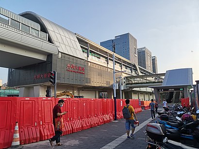
Guangming Street station (Chinese: 光明大街站; pinyin: Guāngmíng Dàjiē Zhàn), is a station on Line 6 of the Shenzhen Metro. It opened on 18 August 2020.Wiki
Get around 光明街道 by public transit!
Traveling around 光明街道 has never been so easy. See step by step directions as you travel to any attraction, street or major public transit station. View bus and train schedules, arrival times, service alerts and detailed routes on a map, so you know exactly how to get to anywhere in 光明街道.
When traveling to any destination around 光明街道 use Moovit's Live Directions with Get Off Notifications to know exactly where and how far to walk, how long to wait for your line, and how many stops are left. Moovit will alert you when it's time to get off — no need to constantly re-check whether yours is the next stop.
Wondering how to use public transit in 光明街道 or how to pay for public transit in 光明街道? Moovit public transit app can help you navigate your way with public transit easily, and at minimum cost. It includes public transit fees, ticket prices, and costs. Looking for a map of 光明街道 public transit lines? Moovit public transit app shows all public transit maps in 光明街道 with all Bus and Metro routes and stops on an interactive map.
Shenzhen has 2 transit type(s), including: Bus and Metro, operated by several transit agencies, including 深圳地铁, 深圳公交, 社区微巴 and 港铁(深圳)