Directions to 新御徒町 (台東区) with public transportation
The following transit lines have routes that pass near 新御徒町
How to get to 新御徒町 by bus?
Click on the bus route to see step by step directions with maps, line arrival times and updated time schedules.
Metro stations near 新御徒町 in 台東区
- 新御徒町 Shin-Okachimachi, 1 min walk,
- 稲荷町 Inaricho, 7 min walk,
- 仲御徒町 Naka-Okachimachi, 8 min walk,
- 御徒町 Okachimachi, 10 min walk,
- 上野 Ueno, 14 min walk,
What are the closest stations to 新御徒町?
The closest stations to 新御徒町 are:
- 新御徒町 Shin-Okachimachi is 50 meters away, 1 min walk.
- 稲荷町 Inaricho is 516 meters away, 7 min walk.
- 仲御徒町 Naka-Okachimachi is 606 meters away, 8 min walk.
- 御徒町 Okachimachi is 708 meters away, 10 min walk.
- 上野 Ueno is 1037 meters away, 14 min walk.
Which bus lines stop near 新御徒町?
These bus lines stop near 新御徒町: 上23, 上69, 都02.
What’s the nearest metro station to 新御徒町 in 台東区?
The nearest metro station to 新御徒町 in 台東区 is 新御徒町 Shin-Okachimachi. It’s a 1 min walk away.
What time is the first bus to 新御徒町 in 台東区?
The 都02 is the first bus that goes to 新御徒町 in 台東区. It stops nearby at 6:11 AM.
What time is the last bus to 新御徒町 in 台東区?
The 都02 is the last bus that goes to 新御徒町 in 台東区. It stops nearby at 11:26 PM.
See 新御徒町, 台東区, on the map
Public Transit to 新御徒町 in 台東区
Wondering how to get to 新御徒町 in 台東区, Japan? Moovit helps you find the best way to get to 新御徒町 with step-by-step directions from the nearest public transit station.
Moovit provides free maps and live directions to help you navigate through your city. View schedules, routes, timetables, and find out how long does it take to get to 新御徒町 in real time.
Looking for the nearest stop or station to 新御徒町? Check out this list of stops closest to your destination: 新御徒町 Shin-Okachimachi; 稲荷町 Inaricho; 仲御徒町 Naka-Okachimachi; 御徒町 Okachimachi; 上野 Ueno.
Bus: 上23, 上69, 都02.Metro: 大江戸線 OEDO LINE, 銀座線 GINZA LINE, 日比谷線 HIBIYA LINE, 京浜東北線・根岸線 KEIHIN-TOHOKU-NEGISHI LINE, 山手線 YAMANOTE LINE, 宇都宮線 UTSUNOMIYA LINE, 常磐線快速 JOBAN RAPID LINE, 高崎線 TAKASAKI LINE.
Want to see if there’s another route that gets you there at an earlier time? Moovit helps you find alternative routes or times. Get directions from and directions to 新御徒町 easily from the Moovit App or Website.
We make riding to 新御徒町 easy, which is why over 1.5 million users, including users in 台東区, trust Moovit as the best app for public transit. You don’t need to download an individual bus app or train app, Moovit is your all-in-one transit app that helps you find the best bus time or train time available.
For information on prices of bus, costs and ride fares to 新御徒町, please check the Moovit app.
Use the app to navigate to popular places including to the airport, hospital, stadium, grocery store, mall, coffee shop, school, college, and university.
新御徒町 Address: 春日通り street in 台東区
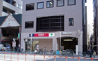
Shin-okachimachi Station (新御徒町駅, Shin-okachimachi-eki) is a subway station in Taitō, Tokyo, Japan, jointly operated by Toei Subway and Metropolitan Intercity Railway Company.Wiki
Attractions near 新御徒町
Shin-Okachimachi Station (新御徒町駅),一軒め酒場,ロイスジャパン,インテリア オノ,第二竹屋ビル,個別指導スクールIe,魚旬,タロウ歯科クリニック,すき家,ブティック ウフ,フラワーショップ大原,FamilyMart (ファミリーマート 新御徒町駅前店),新御徒町ビル,ちよだ鮨,Shin okachimachi Eki,神宮館,ファミリーマート,理浩歯科,啓文社,ふしぎどうHow to get to popular attractions in 台東区 with public transit
LUZ e SOMBRA Culture shop (ルース イ ソンブラ カルチャーショップ), 横浜市,神奈川県立県民ホール, 横浜市,ミスターダンディ パートⅡ, 台東区,日赤医療センター前バス停, 渋谷区,アメダス八王子地域気象観測所, 八王子市,恵比寿CreAto, 渋谷区,千鳥ヶ淵, 千代田区,千葉刑務所, 千葉市,日産自動車 座間事業所,J-WAVE けやき坂スタジオ, 港区,舟和本店 浦和工場直売店, さいたま市,鎮守馬橋稲荷神社, 杉並区,Sumitomo Fudosan Iidabashi First Tower (住友不動産飯田橋ファーストタワー), 文京区,24Kaikan (24会館 上野店), 台東区,新鮮市場フレッツ, 練馬区,神奈川県パスポートセンター, 横浜市,Ninja Money Exchange, 千代田区,舎人公園, 足立区,三殿台遺跡, 横浜市,横浜中華学院, 横浜市Get around Tokyo by public transit!
Traveling around Tokyo has never been so easy. See step by step directions as you travel to any attraction, street or major public transit station. View bus and train schedules, arrival times, service alerts and detailed routes on a map, so you know exactly how to get to anywhere in Tokyo.
When traveling to any destination around Tokyo use Moovit's Live Directions with Get Off Notifications to know exactly where and how far to walk, how long to wait for your line, and how many stops are left. Moovit will alert you when it's time to get off — no need to constantly re-check whether yours is the next stop.
Wondering how to use public transit in Tokyo or how to pay for public transit in Tokyo? Moovit public transit app can help you navigate your way with public transit easily, and at minimum cost. It includes public transit fees, ticket prices, and costs. Looking for a map of Tokyo public transit lines? Moovit public transit app shows all public transit maps in Tokyo with all Bus and Metro routes and stops on an interactive map.
Tokyo has 2 transit type(s), including: Bus and Metro, operated by several transit agencies, including JR East, Tokyo Metro, Toei, Tokyo Waterfront Area Rapid Transit, Transportation Bureau, City of Yokohama, Sagami Railway, 都営バス, Kokusai Kogyo Bus, Tokyu Bus, Keio Bus, Kanto Bus, Nishi Tokyo Bus, Sotetsu Bus