Directions to 様似町 with public transportation
The following transit lines have routes that pass near 様似町
How to get to 様似町 by bus?
Click on the bus route to see step by step directions with maps, line arrival times and updated time schedules.
Which bus line stops near 様似町?
札幌~様似
How much is the bus fare to 様似町?
The bus fare to 様似町 costs about ¥160.00 - ¥450.00.
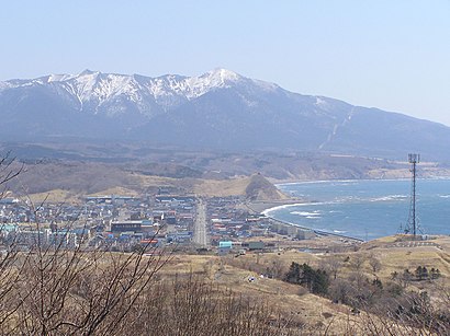
See 様似町 on the map
Public Transportation to 様似町
Wondering how to get to 様似町, Japan? Moovit helps you find the best way to get to 様似町 with step-by-step directions from the nearest public transit station.
Moovit provides free maps and live directions to help you navigate through your city. View schedules, routes, timetables, and find out how long does it take to get to 様似町 in real time.
Bus: 札幌~様似.
Want to see if there’s another route that gets you there at an earlier time? Moovit helps you find alternative routes or times. Get directions from and directions to 様似町 easily from the Moovit App or Website.
We make riding to 様似町 easy, which is why over 1.5 million users, including users in Hokkaido, trust Moovit as the best app for public transit. You don’t need to download an individual bus app or train app, Moovit is your all-in-one transit app that helps you find the best bus time or train time available.
For information on prices of bus, costs and ride fares to 様似町, please check the Moovit app.
Use the app to navigate to popular places including to the airport, hospital, stadium, grocery store, mall, coffee shop, school, college, and university.
Location: Hokkaido
Popular routes to 様似町
Attractions near 様似町
How to get to popular places in Hokkaido with public transit
Get around Hokkaido by public transit!
Traveling around Hokkaido has never been so easy. See step by step directions as you travel to any attraction, street or major public transit station. View bus and train schedules, arrival times, service alerts and detailed routes on a map, so you know exactly how to get to anywhere in Hokkaido.
When traveling to any destination around Hokkaido use Moovit's Live Directions with Get Off Notifications to know exactly where and how far to walk, how long to wait for your line, and how many stops are left. Moovit will alert you when it's time to get off — no need to constantly re-check whether yours is the next stop.
Wondering how to use public transit in Hokkaido or how to pay for public transit in Hokkaido? Moovit public transit app can help you navigate your way with public transit easily, and at minimum cost. It includes public transit fees, ticket prices, and costs. Looking for a map of Hokkaido public transit lines? Moovit public transit app shows all public transit maps in Hokkaido with all bus routes and stops on an interactive map.
Hokkaido has 1 transit type(s), including: bus, operated by several transit agencies, including 北海道中央バス, ジェイ・アール北海道バス, 函館市電, 道北バス, 宗谷バス, じょうてつ, 空知交通, 旭川電気軌道, 士幌町コミュニティ, 白糠町コミュニティ, 恵庭市, 斜里町コミュニティ, 蘭越町コミュニティ, 浦臼町コミュニティ and 札幌ばんけい