영등포역 stop - Sunday schedule
| Line | Direction | Time |
|---|---|---|
| 6008 | 영등포역 | 오전 5:37 |
| 6008 | 영등포역 | 오전 6:40 |
| 6008 | 영등포역 | 오전 7:49 |
| 6008 | 영등포역 | 오전 8:53 |
| 6008 | 영등포역 | 오전 9:53 |
| 6008 | 영등포역 | 오전 10:46 |
| 6008 | 영등포역 | 오전 11:43 |
| 6008 | 영등포역 | 오후 12:43 |
| 6008 | 영등포역 | 오후 1:43 |
| 6008 | 영등포역 | 오후 2:43 |
| 6008 | 영등포역 | 오후 3:50 |
| 6008 | 영등포역 | 오후 4:53 |
| 6008 | 영등포역 | 오후 5:53 |
| 6008 | 영등포역 | 오후 6:53 |
| 6008 | 영등포역 | 오후 7:53 |
| 6008 | 영등포역 | 오후 8:42 |
| 6008 | 영등포역 | 오후 9:38 |
Directions to 영등포역 stop (Seoul) with public transit
The following transit lines have routes that pass near 영등포역
How to get to 영등포역 stop by bus?
Click on the bus route to see step by step directions with maps, line arrival times and updated time schedules.
How to get to 영등포역 stop by subway?
Click on the subway route to see step by step directions with maps, line arrival times and updated time schedules.
Bus stops near 영등포역 stop in Seoul
- 영등포역, 2 min walk,
- 경방타임스퀘어.신세계백화점, 4 min walk,
- 신세계백화점, 4 min walk,
- 영등포시장로터리방면, 5 min walk,
- 영등포로터리, 5 min walk,
- 영등포역후문, 17 min walk,
Subway stations near 영등포역 station in Seoul
- 영등포시장 Yeongdeungpo Market, 7 min walk,
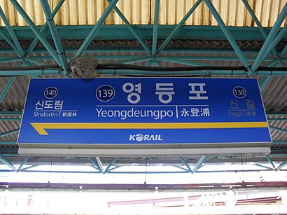
- 영등포 Yeongdeungpo, 9 min walk,
Bus lines to 영등포역 stop in Seoul
- 10부천, 옥길동입구 - 여의도환승센터,
- N16, 도봉산역광역환승센터 - 온수동,
- 83부천, 대장공영차고지 - 여의도환승센터,
- 88부천, 대장공영차고지 - 여의도환승센터,
- 11-1광명, 도덕산도시자연공원 - 여의도환승센터,
- 11-2광명, 고속철도광명역 - 여의도환승센터,
- 160, 도봉산역광역환승센터 - 온수동,
- 301안산, 본오아파트앞 - 여의도환승센터,
- 320안산, 경원여객 - 여의도환승센터,
- 503, 광명공영차고지 - 남대문,
- 510시흥, 산업기술대.경기과기대 - 여의도환승센터,
- 530시흥, 포동차고지 - 여의도환승센터,
- 600, 온수동 - 광화문,
- 662, 외발산동 - 여의나루역,
- 88-1부천, 송내역남부 - 대장공영차고지,
- 2500인천, 롯데마트 - 서울역사박물관(경교장),
- 5615, 난곡 - 여의도,
- 5618, 구로동 - 구로동,
- 6512, 구로동 - 서울대,
- 6513, 철산동 - 서울대,
What are the closest stations to 영등포역?
The closest stations to 영등포역 are:
- 영등포역 is 137 meters away, 2 min walk.
- 경방타임스퀘어.신세계백화점 is 260 meters away, 4 min walk.
- 신세계백화점 is 292 meters away, 4 min walk.
- 영등포시장로터리방면 is 379 meters away, 5 min walk.
- 영등포로터리 is 382 meters away, 5 min walk.
- 영등포시장 Yeongdeungpo Market is 510 meters away, 7 min walk.
- 영등포 Yeongdeungpo is 700 meters away, 9 min walk.
- 영등포역후문 is 1279 meters away, 17 min walk.
Which bus lines stop near 영등포역?
These bus lines stop near 영등포역: 10부천, 160, 5618, 5714, 600, 6008, 670, 760.
Which subway line stops near 영등포역?
1
What’s the nearest subway station to 영등포역 in Seoul?
The nearest subway station to 영등포역 in Seoul is 영등포시장 Yeongdeungpo Market. It’s a 7 min walk away.
What’s the nearest bus stop to 영등포역 in Seoul?
The nearest bus stop to 영등포역 in Seoul is 영등포역. It’s a 2 min walk away.
What time is the first subway to 영등포역 in Seoul?
The 1 is the first subway that goes to 영등포역 in Seoul. It stops nearby at 5:04 AM.
What time is the last subway to 영등포역 in Seoul?
The 1 is the last subway that goes to 영등포역 in Seoul. It stops nearby at 12:25 AM.
What time is the first bus to 영등포역 in Seoul?
The N16 is the first bus that goes to 영등포역 in Seoul. It stops nearby at 3:21 AM.
What time is the last bus to 영등포역 in Seoul?
The N16 is the last bus that goes to 영등포역 in Seoul. It stops nearby at 3:21 AM.
See 영등포역 stop, Seoul, on the map
Public transit to 영등포역 stop in Seoul
Looking for directions to 영등포역 in Seoul, South Korea?
Download the Moovit App to find the current schedule and step-by-step directions for Subway or Bus routes that pass through 영등포역.
Looking for the nearest stops closest to 영등포역 ? Check out this list of closest stops to your destination: 영등포역; 경방타임스퀘어.신세계백화점; 신세계백화점; 영등포시장로터리방면; 영등포로터리; 영등포시장 Yeongdeungpo Market; 영등포 Yeongdeungpo; 영등포역후문.
Bus: 10부천, 160, 5618, 5714, 600, 6008, 670, 760, N16, 83부천, 88부천, 11-1광명, 605, 661, 5안양, 871고양, 6640A, 300인천.Subway: 1, 2, 5.
We make riding on public transit to 영등포역 easy, which is why over 1.5 million users, including users in Seoul trust Moovit as the best app for public transit.
Use the app to navigate to popular places including to the airport, hospital, stadium, grocery store, mall, coffee shop, school, college, and university.
The first line to this stop is 6008, at 오전 5:37, and the last line is 6008 at 오후 9:38.
South Korea Seoul Yongsan-gu 경인로 489
This stop serves 공항’s lines
Get around Seoul by public transit!
Traveling around Seoul has never been so easy. See step by step directions as you travel to any attraction, street or major public transit station. View bus and train schedules, arrival times, service alerts and detailed routes on a map, so you know exactly how to get to anywhere in Seoul.
When traveling to any destination around Seoul use Moovit's Live Directions with Get Off Notifications to know exactly where and how far to walk, how long to wait for your line, and how many stops are left. Moovit will alert you when it's time to get off — no need to constantly re-check whether yours is the next stop.
Wondering how to use public transit in Seoul or how to pay for public transit in Seoul? Moovit public transit app can help you navigate your way with public transit easily, and at minimum cost. It includes public transit fees, ticket prices, and costs. Looking for a map of Seoul public transit lines? Moovit public transit app shows all public transit maps in Seoul with all subway or bus routes and stops on an interactive map.
Seoul has 2 transit type(s), including: subway or bus, operated by several transit agencies, including 서울교통공사, 인천교통공사, 네오트랜스, 한국철도공사, 네오트랜스, 경기, 공항, 간선, 지선, 순환, 광역, 인천, 김포 도시철도, 경기고속 and 대원고속