See 15th Ave, Inner Sunset, Sf, on the map
Directions to 15th Ave (Inner Sunset, Sf) with public transportation
The following transit lines have routes that pass near 15th Ave
 Bus:
Bus: - Light Rail:
How to get to 15th Ave by bus?
Click on the bus route to see step by step directions with maps, line arrival times and updated time schedules.
Bus stations near 15th Ave in Inner Sunset, Sf
- Judah St & 15th Ave,2 min walk,
- Lincoln Way & 15th Ave,4 min walk,
Bus lines to 15th Ave in Inner Sunset, Sf
- N,Judah,
- N BUS,Judah Bus,
- N OWL,Owl Judah,
- 7,Transit Center,
What are the closest stations to 15th Ave?
The closest stations to 15th Ave are:
- Judah St & 15th Ave is 127 yards away, 2 min walk.
- Lincoln Way & 15th Ave is 332 yards away, 4 min walk.
Which bus lines stop near 15th Ave?
These bus lines stop near 15th Ave: 28, 28R, 7.
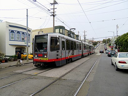
Which light rail line stops near 15th Ave?
N
What’s the nearest bus stop to 15th Ave in Inner Sunset, Sf?
The nearest bus stop to 15th Ave in Inner Sunset, Sf is Judah St & 15th Ave. It’s a 2 min walk away.
See 15th Ave, Inner Sunset, Sf, on the map
Public Transit to 15th Ave in Inner Sunset, Sf
Wondering how to get to 15th Ave in Inner Sunset, Sf, United States? Moovit helps you find the best way to get to 15th Ave with step-by-step directions from the nearest public transit station.
Moovit provides free maps and live directions to help you navigate through your city. View schedules, routes, timetables, and find out how long does it take to get to 15th Ave in real time.
Looking for the nearest stop or station to 15th Ave? Check out this list of stops closest to your destination: Judah St & 15th Ave; Lincoln Way & 15th Ave.
Bus:Light Rail:
Want to see if there’s another route that gets you there at an earlier time? Moovit helps you find alternative routes or times. Get directions from and directions to 15th Ave easily from the Moovit App or Website.
We make riding to 15th Ave easy, which is why over 1.5 million users, including users in Inner Sunset, Sf, trust Moovit as the best app for public transit. You don’t need to download an individual bus app or train app, Moovit is your all-in-one transit app that helps you find the best bus time or train time available.
For information on prices of bus, light rail, BART and cable car, costs and ride fares to 15th Ave, please check the Moovit app.
Use the app to navigate to popular places including to the airport, hospital, stadium, grocery store, mall, coffee shop, school, college, and university.
15th Ave Address: San Francisco, CA 94118 street in Inner Sunset, Sf
Attractions near 15th Ave
Moonrise Intimates,Won Yee Daycare,1383 15th Avenue,1303,San Francisco Super Cab,Andy Sham - Farmers Insurance,Mignonette Consulting,Eric Wong, DDS,Parkside Wash & Dry,Daniel Onyike-Farmers Insurance,Mike McFarlin ?Insurance Agency, LLC,Sunset Shiatsu,Forum Renovation Company,Paul's Hair Design,Judah St (15th and judah),Hotel cats,Glen Park Day Spa,Sunset Academy of Music,Pacific Delta Realty,The AvantHow to get to popular attractions in Inner Sunset, Sf with public transit
Downtown San Jose, San Jose,California's Great America, Santa Clara,Whole Foods Market, Walnut Creek,The Home Depot, Concord,BJ's Restaurant and Brewhouse, Cupertino,Nordstrom Broadway Plaza in Walnut Creek, Walnut Creek,Colma, Colma,City of Newark, Newark,City of Pleasanton, Pleasanton,Nordstrom Stoneridge Mall in Pleasanton, Pleasanton,Regal Cinemas Hacienda Crossings 21 & IMAX, Dublin,Westgate Shopping Center, San Jose,Fremont BART Station, Fremont,Lawrence Livermore National Laboratory, Livermore,Mountain View Caltrain Station,Nordstrom Valley Fair, San Jose,Costco Wholesale, San Jose,McCarthy Ranch, Milpitas,Costco Wholesale, Antioch,Walmart Supercenter, AntiochGet around Inner Sunset, Sf by public transit!
Traveling around Inner Sunset, Sf has never been so easy. See step by step directions as you travel to any attraction, street or major public transit station. View bus and train schedules, arrival times, service alerts and detailed routes on a map, so you know exactly how to get to anywhere in Inner Sunset, Sf.
When traveling to any destination around Inner Sunset, Sf use Moovit's Live Directions with Get Off Notifications to know exactly where and how far to walk, how long to wait for your line, and how many stops are left. Moovit will alert you when it's time to get off — no need to constantly re-check whether yours is the next stop.
Wondering how to use public transit in Inner Sunset, Sf or how to pay for public transit in Inner Sunset, Sf? Moovit public transit app can help you navigate your way with public transit easily, and at minimum cost. It includes public transit fees, ticket prices, and costs. Looking for a map of Inner Sunset, Sf public transit lines? Moovit public transit app shows all public transit maps in Inner Sunset, Sf with all bus, light rail, BART or cable car routes and stops on an interactive map.
Inner Sunset, Sf has 4 transit type(s), including: bus, light rail, BART or cable car, operated by several transit agencies, including BART, Bay Area Rapid Transit, Muni Metro, Caltrain, VTA, Capitol Corridor, Sonoma Marin Area Rail Transit, MUNI, VTA, SF Cable Car, AC Transit, Dumbarton Express, Golden Gate Transit, County Connection and SamTrans