Directions to 16th & California (Denver) with public transportation
The following transit lines have routes that pass near 16th & California
How to get to 16th & California by bus?
Click on the bus route to see step by step directions with maps, line arrival times and updated time schedules.
How to get to 16th & California by train?
Click on the train route to see step by step directions with maps, line arrival times and updated time schedules.
Bus stations near 16th & California in Denver
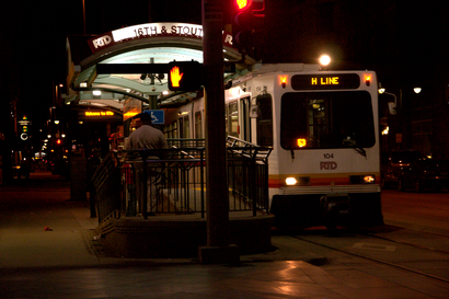
- 16th Street Mall & Welton St, 2 min walk,
- 17th St & California St [ Z Stop ], 3 min walk,
- California St & 17th St, 3 min walk,
- 15th St & California St [ X Stop ], 3 min walk,
- 17th St & Stout St [ Y Stop ], 4 min walk,
- Stout St & 16th Street Mall, 4 min walk,
- 17th St & Welton St [ X Stop ], 4 min walk,
- 15th St & Welton St [ Z Stop ], 5 min walk,
Light Rail stations near 16th & California in Denver
- Union Station Light Rail, 13 min walk,
Train stations near 16th & California in Denver
- Union Station, 13 min walk,
Bus lines to 16th & California in Denver
- MALLRIDE, Free Mallride Union Station,
- 0, Broadway Stn,
- 6, Aurora Metro Cntr Via 6th,
- 19, Civic Center Station,
- 48, Civic Center Via E 48th,
- 52, Ward & 64th Via W 50th Ave,
- 28, 28th Avenue,
- 38, West 38th Avenue,
- 43, Martin Luther King Blvd,
- 44, 44th Avenue,
- 9, West 10th Avenue,
- 15, East Colfax Avenue,
- 15L, East Colfax Limited,
- 10, 9th Clermont Via 12th Ave,
- 1, Lakewood Commons,
- 20, Colfax & Billings,
- 8, Wagon Rd Pnr,
What are the closest stations to 16th & California?
The closest stations to 16th & California are:
- 16th Street Mall & Welton St is 105 yards away, 2 min walk.
- 17th St & California St [ Z Stop ] is 206 yards away, 3 min walk.
- California St & 17th St is 219 yards away, 3 min walk.
- 15th St & California St [ X Stop ] is 222 yards away, 3 min walk.
- 17th St & Stout St [ Y Stop ] is 268 yards away, 4 min walk.
- Stout St & 16th Street Mall is 314 yards away, 4 min walk.
- 17th St & Welton St [ X Stop ] is 316 yards away, 4 min walk.
- 15th St & Welton St [ Z Stop ] is 336 yards away, 5 min walk.
- Union Station Light Rail is 1020 yards away, 13 min walk.
- Union Station is 1035 yards away, 13 min walk.
Which bus lines stop near 16th & California?
These bus lines stop near 16th & California: 0, 15, 15L, 28, 44, 52, 6, 9.
Which train line stops near 16th & California?
G
What’s the nearest light rail station to 16th & California in Denver?
The nearest light rail station to 16th & California in Denver is Union Station Light Rail. It’s a 13 min walk away.
What’s the nearest train station to 16th & California in Denver?
The nearest train station to 16th & California in Denver is Union Station. It’s a 13 min walk away.
What’s the nearest bus stop to 16th & California in Denver?
The nearest bus stop to 16th & California in Denver is 16th Street Mall & Welton St. It’s a 2 min walk away.
What time is the first light rail to 16th & California in Denver?
The E is the first light rail that goes to 16th & California in Denver. It stops nearby at 4:19 AM.
What time is the last light rail to 16th & California in Denver?
The W is the last light rail that goes to 16th & California in Denver. It stops nearby at 12:35 AM.
What time is the first train to 16th & California in Denver?
The A is the first train that goes to 16th & California in Denver. It stops nearby at 3:00 AM.
What time is the last train to 16th & California in Denver?
The CALIFORNIA ZEPHYR is the last train that goes to 16th & California in Denver. It stops nearby at 6:59 PM.
What time is the first bus to 16th & California in Denver?
The 15 is the first bus that goes to 16th & California in Denver. It stops nearby at 3:48 AM.
What time is the last bus to 16th & California in Denver?
The 15 is the last bus that goes to 16th & California in Denver. It stops nearby at 1:23 AM.
See 16th & California, Denver, on the map
Public Transit to 16th & California in Denver
Wondering how to get to 16th & California in Denver, United States? Moovit helps you find the best way to get to 16th & California with step-by-step directions from the nearest public transit station.
Moovit provides free maps and live directions to help you navigate through your city. View schedules, routes, timetables, and find out how long does it take to get to 16th & California in real time.
Looking for the nearest stop or station to 16th & California? Check out this list of stops closest to your destination: 16th Street Mall & Welton St; 17th St & California St [ Z Stop ]; California St & 17th St; 15th St & California St [ X Stop ]; 17th St & Stout St [ Y Stop ]; Stout St & 16th Street Mall; 17th St & Welton St [ X Stop ]; 15th St & Welton St [ Z Stop ]; Union Station Light Rail; Union Station.
Bus: 0, 15, 15L, 28, 44, 52, 6, 9, MALLRIDE, 19, 48, 38, 43, 10.Train: G, A, B, N, CALIFORNIA ZEPHYR.
Want to see if there’s another route that gets you there at an earlier time? Moovit helps you find alternative routes or times. Get directions from and directions to 16th & California easily from the Moovit App or Website.
We make riding to 16th & California easy, which is why over 1.5 million users, including users in Denver, trust Moovit as the best app for public transit. You don’t need to download an individual bus app or train app, Moovit is your all-in-one transit app that helps you find the best bus time or train time available.
For information on prices of bus, light rail and train, costs and ride fares to 16th & California, please check the Moovit app.
Use the app to navigate to popular places including to the airport, hospital, stadium, grocery store, mall, coffee shop, school, college, and university.
16th & California Address: California Street street in Denver
Attractions near 16th & California
RTD - 16th & California Light Rail Station,Sixteenth Street Locksmith,Jason's 16th St Locksmith,Denver Chiropractic Care & Treatment Services,Borus' Hotdog Stand,Denver Beer Week,Royal Detail,Laz Parking,Block 162 Lot,Flame-Restaurant-Tricolor,Blink Charging,Haynes and Boone,RTD - 16th & Stout Light Rail Station,Rocky Mountain Arsenal,Peaks Lounge Hyatt Regency,AC Hotel by Marriott Denver Downtown,Milehigh Vacations,Stu Kennedy Event Photography,Bar AC,Tips ColoradoHow to get to popular attractions in Denver with public transit
Grand Hyatt-Vail, Vail,Eldora Mountain Resort, Denver,Douglas County Combined Court, Castle Rock,Louisville, CO, Louisville,Centennial Colorado, Centennial,Limousine Service of Denver, Aurora,Capitol Hill, Denver,RTD-Dayton Station, Greenwood Village,Ucar & Ncar / Foothills Lab, Boulder,Auraria Campus, Denver,Alameda & Havana Park-N-Ride, Aurora,South High School, Denver,Green Valley Ranch, Denver,Aurora Mall, Aurora,Blue Moon Brewing Company @ RiNo District, Denver,Clark's Market, Snowmass Village,Denver Broncos Practice Field, Dove Valley,Denver Dispensary, Denver,Cheesman Park, Denver,4040 Quebec Street, DenverGet around Denver - Boulder, CO by public transit!
Traveling around Denver - Boulder, CO has never been so easy. See step by step directions as you travel to any attraction, street or major public transit station. View bus and train schedules, arrival times, service alerts and detailed routes on a map, so you know exactly how to get to anywhere in Denver - Boulder, CO.
When traveling to any destination around Denver - Boulder, CO use Moovit's Live Directions with Get Off Notifications to know exactly where and how far to walk, how long to wait for your line, and how many stops are left. Moovit will alert you when it's time to get off — no need to constantly re-check whether yours is the next stop.
Wondering how to use public transit in Denver - Boulder, CO or how to pay for public transit in Denver - Boulder, CO? Moovit public transit app can help you navigate your way with public transit easily, and at minimum cost. It includes public transit fees, ticket prices, and costs. Looking for a map of Denver - Boulder, CO public transit lines? Moovit public transit app shows all public transit maps in Denver - Boulder, CO with all Bus, Train, Light Rail and Gondola routes and stops on an interactive map.
Denver - Boulder, CO has 4 transit type(s), including: Bus, Train, Light Rail and Gondola, operated by several transit agencies, including Regional Transportation District, Colorado Department of Transportation, University of Colorado Boulder, Summit Stage, Groome Transportation, City of Boulder, Transfort, Bustang Outrider, Pueblo Transit, Rocky Mountain National Park Shuttles, Epic Mountain Express, Peak 1 Express, Boulder County, Breckenridge Free Ride, Home James Transportation