Directions to 34th Street–Herald Square (Manhattan) with public transportation
The following transit lines have routes that pass near 34th Street–Herald Square
How to get to 34th Street–Herald Square by bus?
Click on the bus route to see step by step directions with maps, line arrival times and updated time schedules.
How to get to 34th Street–Herald Square by train?
Click on the train route to see step by step directions with maps, line arrival times and updated time schedules.
How to get to 34th Street–Herald Square by subway?
Click on the subway route to see step by step directions with maps, line arrival times and updated time schedules.
Train stations near 34th Street–Herald Square in Manhattan
- 33rd Street, 1 min walk,
- 34 St-Penn Station, 4 min walk,
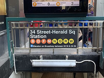
Subway station near 34th Street–Herald Square in Manhattan
- 34 St-Herald Sq, 1 min walk,
Bus stops near 34th Street–Herald Square in Manhattan
- W 32 St/Broadway, 1 min walk,
- W 34 St/Broadway, 2 min walk,
- Av Of the Americas/W 34 St, 2 min walk,
- 6 Av/W 35 St, 3 min walk,
- 6 Av/W 36 St, 4 min walk,
- 7 Ave/W 34 St, 5 min walk,
Bus lines to 34th Street–Herald Square in Manhattan
- Q32, Jackson Hts Northern-81 St Via Roosevelt,
- SIM23, Annadale Via Arden Av,
- SIM24, Midtown Via 34 St Via Madison Av,
- M34-SBS, Select Bus East Side Fdr Dr Crosstown,
- M34A-SBS, Select Bus Pa Bus Trm Via 34 St Via 8 Av,
- SIM1C, Eltingville - Manhattan Express,
- SIM3, Pt. Richmond - Midtown Manhattan Express,
- SIM3C, Pt. Richmond - Manhattan Express,
- M5, George Washington Bridge - 31 St & 6 Av,
- M7, Harlem - 14th Street,
- SIM10, Eltingville - Midtown Manhattan Express,
- M55, W 44 St - South Ferry,
- BXM2, Riverdale - West Midtown,
- QM10, Lefrak City - Midtown Via 6Th Av,
- QM12, Forest Hills - Midtown Via 6Th Av,
- QM24, Glendale - Midtown Via 6Th Av,
- QM2, Bay Terrace Bell Bl Via Whitestone Exy,
- QM20, Bay Terrace 211 St Via Willets Pt Bl,
- QM3, Midtown 57 St Via 6 Av,
- QM4, Electchester 164 St Via Jewel Av,
What are the closest stations to 34th Street–Herald Square?
The closest stations to 34th Street–Herald Square are:
- 33rd Street is 19 yards away, 1 min walk.
- 34 St-Herald Sq is 55 yards away, 1 min walk.
- W 32 St/Broadway is 69 yards away, 1 min walk.
- W 34 St/Broadway is 129 yards away, 2 min walk.
- Av Of the Americas/W 34 St is 130 yards away, 2 min walk.
- 6 Av/W 35 St is 195 yards away, 3 min walk.
- 6 Av/W 36 St is 284 yards away, 4 min walk.
- 34 St-Penn Station is 291 yards away, 4 min walk.
- 7 Ave/W 34 St is 343 yards away, 5 min walk.
Which bus lines stop near 34th Street–Herald Square?
These bus lines stop near 34th Street–Herald Square: M101, M102, M15, M2, M7, Q101, SIM1C.
Which train lines stop near 34th Street–Herald Square?
These train lines stop near 34th Street–Herald Square: HARLEM, HUDSON, PORT WASHINGTON BRANCH, RONKONKOMA BRANCH.
Which subway lines stop near 34th Street–Herald Square?
These subway lines stop near 34th Street–Herald Square: D, F, Q.
What’s the nearest subway station to 34th Street–Herald Square in Manhattan?
The nearest subway station to 34th Street–Herald Square in Manhattan is 34 St-Herald Sq. It’s a 1 min walk away.
What’s the nearest train station to 34th Street–Herald Square in Manhattan?
The nearest train station to 34th Street–Herald Square in Manhattan is 33rd Street. It’s a 1 min walk away.
What’s the nearest bus station to 34th Street–Herald Square in Manhattan?
The nearest bus station to 34th Street–Herald Square in Manhattan is W 32 St/Broadway. It’s a 1 min walk away.
What time is the first subway to 34th Street–Herald Square in Manhattan?
The D is the first subway that goes to 34th Street–Herald Square in Manhattan. It stops nearby at 3:03 AM.
What time is the last subway to 34th Street–Herald Square in Manhattan?
The N is the last subway that goes to 34th Street–Herald Square in Manhattan. It stops nearby at 3:57 AM.
What time is the first train to 34th Street–Herald Square in Manhattan?
The PORT JEFFERSON BRANCH is the first train that goes to 34th Street–Herald Square in Manhattan. It stops nearby at 3:01 AM.
What time is the last train to 34th Street–Herald Square in Manhattan?
The NORTHEAST REGIONAL is the last train that goes to 34th Street–Herald Square in Manhattan. It stops nearby at 5:29 AM.
What time is the first bus to 34th Street–Herald Square in Manhattan?
The SIM1C is the first bus that goes to 34th Street–Herald Square in Manhattan. It stops nearby at 3:02 AM.
What time is the last bus to 34th Street–Herald Square in Manhattan?
The M7 is the last bus that goes to 34th Street–Herald Square in Manhattan. It stops nearby at 3:13 AM.
How much is the subway fare to 34th Street–Herald Square?
The subway fare to 34th Street–Herald Square costs about $2.90.
See 34th Street–Herald Square, Manhattan, on the map
Public Transit to 34th Street–Herald Square in Manhattan
Wondering how to get to 34th Street–Herald Square in Manhattan, United States? Moovit helps you find the best way to get to 34th Street–Herald Square with step-by-step directions from the nearest public transit station.
Moovit provides free maps and live directions to help you navigate through your city. View schedules, routes, timetables, and find out how long does it take to get to 34th Street–Herald Square in real time.
Looking for the nearest stop or station to 34th Street–Herald Square? Check out this list of stops closest to your destination: 33rd Street; 34 St-Herald Sq; W 32 St/Broadway; W 34 St/Broadway; Av Of the Americas/W 34 St; 6 Av/W 35 St; 6 Av/W 36 St; 34 St-Penn Station; 7 Ave/W 34 St.
Bus: M101, M102, M15, M2, M7, Q101, SIM1C, Q32, SIM23, SIM24, M34-SBS, M34A-SBS, SIM3, SIM3C, M5.Train: HARLEM, HUDSON, PORT WASHINGTON BRANCH, RONKONKOMA BRANCH, PATH, PATH, PATH, PATH, ACELA, ADIRONDACK, CARDINAL, CAROLINIAN, CRESCENT.Subway: D, F, Q, B, FX, M.
Want to see if there’s another route that gets you there at an earlier time? Moovit helps you find alternative routes or times. Get directions from and directions to 34th Street–Herald Square easily from the Moovit App or Website.
We make riding to 34th Street–Herald Square easy, which is why over 1.5 million users, including users in Manhattan, trust Moovit as the best app for public transit. You don’t need to download an individual bus app or train app, Moovit is your all-in-one transit app that helps you find the best bus time or train time available.
For information on prices of subway, bus and train, costs and ride fares to 34th Street–Herald Square, please check the Moovit app.
Use the app to navigate to popular places including to the airport, hospital, stadium, grocery store, mall, coffee shop, school, college, and university.
34th Street–Herald Square Address: 6th Avenue street in Manhattan
Places Near 34th Street–Herald Square (Manhattan)
How to get to popular places in New York - New Jersey with public transit
Get around Manhattan by public transit!
Traveling around Manhattan has never been so easy. See step by step directions as you travel to any attraction, street or major public transit station. View bus and train schedules, arrival times, service alerts and detailed routes on a map, so you know exactly how to get to anywhere in Manhattan.
When traveling to any destination around Manhattan use Moovit's Live Directions with Get Off Notifications to know exactly where and how far to walk, how long to wait for your line, and how many stops are left. Moovit will alert you when it's time to get off — no need to constantly re-check whether yours is the next stop.
Wondering how to use public transit in Manhattan or how to pay for public transit in Manhattan? Moovit public transit app can help you navigate your way with public transit easily, and at minimum cost. It includes public transit fees, ticket prices, and costs. Looking for a map of Manhattan public transit lines? Moovit public transit app shows all public transit maps in Manhattan with all Bus, Train, Subway, Light Rail, Ferry and Cable Car routes and stops on an interactive map.
New York - New Jersey has 6 transit type(s), including: Bus, Train, Subway, Light Rail, Ferry and Cable Car, operated by several transit agencies, including MTA Subway, Metro-North Railroad, LIRR, PATH, MTA New York City Transit - Express routes, MTA Bus, NJ Transit, NYC Ferry, NICE bus, Bee-Line Bus, NJ Transit Rail, Norwalk Transit District, CTTransit - Waterbury, Hartford Line and River Valley Transit