See Aeropuerto Internacional Panamá Pacífico, Veracruz, on the map
Directions to Aeropuerto Internacional Panamá Pacífico (Veracruz) with public transportation
The following transit lines have routes that pass near Aeropuerto Internacional Panamá Pacífico
 Bus:
Bus:
How to get to Aeropuerto Internacional Panamá Pacífico by bus?
Click on the bus route to see step by step directions with maps, line arrival times and updated time schedules.
Bus stations near Aeropuerto Internacional Panamá Pacífico in Veracruz
- Stauffer, 112-2,8 min walk,
Bus lines to Aeropuerto Internacional Panamá Pacífico in Veracruz
- AR346,Veracruz,
What are the closest stations to Aeropuerto Internacional Panamá Pacífico?
The closest stations to Aeropuerto Internacional Panamá Pacífico are:
- Stauffer, 112-2 is 612 meters away, 8 min walk.
Which bus line stops near Aeropuerto Internacional Panamá Pacífico?
AR346
What’s the nearest bus stop to Aeropuerto Internacional Panamá Pacífico in Veracruz?
The nearest bus stop to Aeropuerto Internacional Panamá Pacífico in Veracruz is Stauffer, 112-2. It’s a 8 min walk away.
What time is the first bus to Aeropuerto Internacional Panamá Pacífico in Veracruz?
The AR346 is the first bus that goes to Aeropuerto Internacional Panamá Pacífico in Veracruz. It stops nearby at 5:41 AM.
What time is the last bus to Aeropuerto Internacional Panamá Pacífico in Veracruz?
The AR346 is the last bus that goes to Aeropuerto Internacional Panamá Pacífico in Veracruz. It stops nearby at 10:14 PM.
See Aeropuerto Internacional Panamá Pacífico, Veracruz, on the map
Public Transit to Aeropuerto Internacional Panamá Pacífico in Veracruz
Wondering how to get to Aeropuerto Internacional Panamá Pacífico in Veracruz, Panama? Moovit helps you find the best way to get to Aeropuerto Internacional Panamá Pacífico with step-by-step directions from the nearest public transit station.
Moovit provides free maps and live directions to help you navigate through your city. View schedules, routes, timetables, and find out how long does it take to get to Aeropuerto Internacional Panamá Pacífico in real time.
Looking for the nearest stop or station to Aeropuerto Internacional Panamá Pacífico? Check out this list of stops closest to your destination: Stauffer.
Bus:
Want to see if there’s another route that gets you there at an earlier time? Moovit helps you find alternative routes or times. Get directions from and directions to Aeropuerto Internacional Panamá Pacífico easily from the Moovit App or Website.
We make riding to Aeropuerto Internacional Panamá Pacífico easy, which is why over 1.5 million users, including users in Veracruz, trust Moovit as the best app for public transit. You don’t need to download an individual bus app or train app, Moovit is your all-in-one transit app that helps you find the best bus time or train time available.
For information on prices of bus, costs and ride fares to Aeropuerto Internacional Panamá Pacífico, please check the Moovit app.
Use the app to navigate to popular places including to the airport, hospital, stadium, grocery store, mall, coffee shop, school, college, and university.
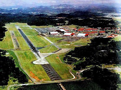
Aeropuerto Internacional Panamá Pacífico Address: Avenida Bryan Fort Kobbe, Veracruz street in Veracruz
Popular routes to Aeropuerto Internacional Panamá Pacífico, Veracruz
Attractions near Aeropuerto Internacional Panamá Pacífico
Panamá Pacifico,Panamá Sector Panamá Oeste Arraijan Panamá Pacífico,Panama Pacifico Panama Pacifico Arraiján,PANAMA PACIFICO RIVER VALLEY,Supermercado Riba Smith,Mindful Pilates Panama,Aeropuerto Internacional Panama Pacifico,PH Mosaic Avenida Blvrd Panamá Pacífico 113 B Panamá,Aeropuerto Internacional Panamá Pacifico,Dell Panamá,Power Club Panamá Pacífico,Helipuerto,Wärtsilä Panamá Services S.A.,Howard Kids Academy,Howard Academy,Grupo Tla,Bosques Del Pacifico Avenida Principal Panama Pacifico,Nativa Avenida Boulevard Panama Pacifico,Nativa Avenida Panama Pacifico,NATIVA PANAMA PACIFICOHow to get to popular attractions in Veracruz with public transit
Viaducto Marino Corredor Sur,Jardín Olímpico, Juan Díaz,Super 99, Victoriano Lorenzo,PH The Rim Tower Apartamento 14-B, Pueblo Nuevo,KFC, Betania,Urbanización Herbruger, Betania,CONWAY, Ancón,TGI Fridays, Ancón,Calle del IPA, Río Abajo,Ciudad Deportiva Kiwanis, Ancón,Fiesta Casino Salsa's Bar & Grill, Curundú,Farmacias Arrocha, Belisario Porras,Hipodromo Presidente Remon Cantera, Juan Díaz,Ph Prisma, Parque Lefevre,Vía Veneto, Curundú,Power Club, Betania,Yoytec Computer, Betania,El Meson del Prado, Betania,Multimax, Betania,Policía Nacional de Panamá, AncónGet around Veracruz by public transit!
Traveling around Veracruz has never been so easy. See step by step directions as you travel to any attraction, street or major public transit station. View bus and train schedules, arrival times, service alerts and detailed routes on a map, so you know exactly how to get to anywhere in Veracruz.
When traveling to any destination around Veracruz use Moovit's Live Directions with Get Off Notifications to know exactly where and how far to walk, how long to wait for your line, and how many stops are left. Moovit will alert you when it's time to get off — no need to constantly re-check whether yours is the next stop.
Wondering how to use public transit in Veracruz or how to pay for public transit in Veracruz? Moovit public transit app can help you navigate your way with public transit easily, and at minimum cost. It includes public transit fees, ticket prices, and costs. Looking for a map of Veracruz public transit lines? Moovit public transit app shows all public transit maps in Veracruz with all bus routes and stops on an interactive map.
Veracruz has 1 transit type(s), including: bus, operated by several transit agencies, including Metro de Panamá, MiBus, Panamá Canal Railway, Fundación Ciudad del Saber, EPACOC, Calypso Ferry, Ferry Las Perlas, COOPSACA, TRANSCOLPILMA, La Chorrera Buses, Rutas Urbanas de Colón S.A., Panamá Regional Buses, TRANSBOSALCO, SITTSPSC and Bus Shuttle