How to get to Amazon Locker-Cruz by bus?
Click on the bus route to see step by step directions with maps, line arrival times and updated time schedules.
From Hilton Arlington National Landing, Arlington County
53 minFrom Seven Corners Center (Seven Corners Shopping Center Falls Church VA), Fairfax County
50 minFrom The Westin Crystal City Hotel, Arlington County
43 minFrom Amazon Hq2, Arlington County
53 minFrom Joint Base Myer – Henderson Hall (JBMHH) | Fort Myer area, Arlington County
56 minFrom Homewood Suites by Hilton Arlington Rosslyn Key Bridge, Arlington County
68 minFrom Hyatt Centric Arlington, Arlington County
62 minFrom Inova Fairfax Hospital, Fairfax County
50 min
How to get to Amazon Locker-Cruz by metro?
Click on the metro route to see step by step directions with maps, line arrival times and updated time schedules.
From Hilton Arlington National Landing, Arlington County
61 minFrom Seven Corners Center (Seven Corners Shopping Center Falls Church VA), Fairfax County
95 minFrom The Westin Crystal City Hotel, Arlington County
53 minFrom Amazon Hq2, Arlington County
54 minFrom Homewood Suites by Hilton Arlington Rosslyn Key Bridge, Arlington County
69 minFrom Hyatt Centric Arlington, Arlington County
61 min
Bus stops near Amazon Locker-Cruz in Alexandria
Metro station near Amazon Locker-Cruz in Alexandria
- Van Dorn Street Metro Station, 38 min walk,VIEW
Bus lines to Amazon Locker-Cruz in Alexandria
What are the closest stations to Amazon Locker-Cruz?
The closest stations to Amazon Locker-Cruz are:
- S Reynolds St+Duke St is 127 yards away, 2 min walk.
- Rt 236 Duke St & Paxton St is 132 yards away, 2 min walk.
- N Ripley St + Duke St is 312 yards away, 4 min walk.
- Van Dorn Street Metro Station is 3177 yards away, 38 min walk.
Which bus lines stop near Amazon Locker-Cruz?
These bus lines stop near Amazon Locker-Cruz: 30, A27, F23.
Which metro line stops near Amazon Locker-Cruz?
BLUE (Franconia-Springfield)
What’s the nearest bus station to Amazon Locker-Cruz in Alexandria?
The nearest bus stations to Amazon Locker-Cruz in Alexandria are S Reynolds St+Duke St and Rt 236 Duke St & Paxton St. The closest one is a 2 min walk away.
What time is the first metro to Amazon Locker-Cruz in Alexandria?
The BLUE is the first metro that goes to Amazon Locker-Cruz in Alexandria. It stops nearby at 5:05 AM.
What time is the last metro to Amazon Locker-Cruz in Alexandria?
The BLUE is the last metro that goes to Amazon Locker-Cruz in Alexandria. It stops nearby at 12:39 AM.
What time is the first bus to Amazon Locker-Cruz in Alexandria?
The A27 is the first bus that goes to Amazon Locker-Cruz in Alexandria. It stops nearby at 4:48 AM.
What time is the last bus to Amazon Locker-Cruz in Alexandria?
The 30 is the last bus that goes to Amazon Locker-Cruz in Alexandria. It stops nearby at 1:23 AM.
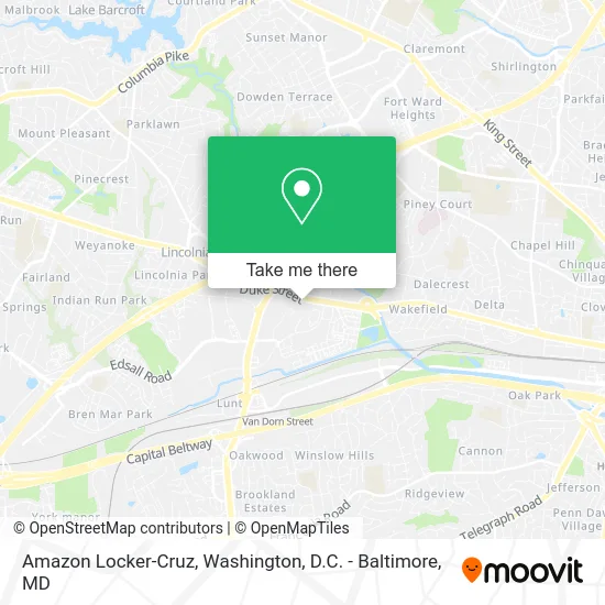
See Amazon Locker-Cruz, Alexandria, on the map
Public Transit to Amazon Locker-Cruz in Alexandria
Wondering how to get to Amazon Locker-Cruz in Alexandria? Moovit helps you find the best way to get to Amazon Locker-Cruz with step-by-step directions from the nearest public transit station.
Moovit provides free maps and live directions to help you navigate through your city. View schedules, routes, timetables, and find out how long does it take to get to Amazon Locker-Cruz in real time.
Looking for the nearest stop or station to Amazon Locker-Cruz? Check out this list of stops closest to your destination: S Reynolds St+Duke St; Rt 236 Duke St & Paxton St; N Ripley St + Duke St; Van Dorn Street Metro Station.
Bus: 30, A27, F23, A28, F24, 32.Metro: BLUE.
Want to see if there’s another route that gets you there at an earlier time? Moovit helps you find alternative routes or times. Get directions from and directions to Amazon Locker-Cruz easily from the Moovit App or Website.
We make riding to Amazon Locker-Cruz easy, which is why over 1.5 million users, including users in Alexandria, trust Moovit as the best app for public transit. You don’t need to download an individual bus app or train app, Moovit is your all-in-one transit app that helps you find the best bus time or train time available.
For information on prices of bus and metro, costs and ride fares to Amazon Locker-Cruz, please check the Moovit app.
Use the app to navigate to popular places including to the airport, hospital, stadium, grocery store, mall, coffee shop, school, college, and university.
Amazon Locker-Cruz Address: 30 S Reynolds St Alexandria, VA 22304 street in Alexandria
- Credit Union 1,
- WESTERN UNION,
- S Reynolds St VA-236,
- Ajs Pizza Cheesesteak,
- Equal Housing Opportunity,
- Repair Rheem Furnaces Hvac,
- LENS CRAFTERS,
- The Tardis,
- Master Trapper,
- Diko Hookah Bar and Lounge,
- DHMS,
- Bambinelli Kids Boutique,
- Hair Nirvana,
- Mercy Health Care Services,
- Brite Maid Services,
- Annemarie Russell, LCSW,
- Fastest Labs of Alexandria,
- Synergy Development and Training LLC,
- Shooter McGee's (Shooter MC Ghee's),
- Pipe Maintenance Plumbers
Places Near Amazon Locker-Cruz (Alexandria)
- Warner Theatre, Washington,
- Basilica of the National Shrine, Washington,
- The Anthem, Washington,
- Capital One Arena, Washington,
- Rock Creek Tennis Center, Washington,
- Georgetown, Washington,
- M&T Bank Stadium, Baltimore,
- Amazon Hq2, Arlington County,
- Westfield Montgomery Mall, Montgomery County,
- National Museum of African American History and Culture, Washington,
- National Mall, Washington,
- Museum Of The Bible, Washington,
- Sibley Memorial Hospital, Washington,
- Washington National Cathedral, Washington,
- PG Mall, Prince George's County,
- Washington DC VA Medical Center, Washington,
- National Zoo, Washington,
- Camden Yards, Baltimore,
- Marriott Marquis Washington, DC, Washington,
- Pennsylvania Ave NW (3rd st and pennsylvania), Washington
How to get to popular places in Washington, D.C. - Baltimore, MD with public transit
Get around Alexandria by public transit!
Traveling around Alexandria has never been so easy. See step by step directions as you travel to any attraction, street or major public transit station. View bus and train schedules, arrival times, service alerts and detailed routes on a map, so you know exactly how to get to anywhere in Alexandria.
When traveling to any destination around Alexandria use Moovit's Live Directions with Get Off Notifications to know exactly where and how far to walk, how long to wait for your line, and how many stops are left. Moovit will alert you when it's time to get off — no need to constantly re-check whether yours is the next stop.
Wondering how to use public transit in Alexandria or how to pay for public transit in Alexandria? Moovit public transit app can help you navigate your way with public transit easily, and at minimum cost. It includes public transit fees, ticket prices, and costs. Looking for a map of Alexandria public transit lines? Moovit public transit app shows all public transit maps in Alexandria with all Bus, Train, Metro, Light Rail and Ferry routes and stops on an interactive map.
Washington, D.C. - Baltimore, MD has 5 transit type(s), including: Bus, Train, Metro, Light Rail and Ferry, operated by several transit agencies, including WMATA, Montgomery County Ride On, Fairfax Connector, TheBus, PRTC, DASH - Alexandria, Arlington Transit (ART), RTA of Central Maryland, MDOT MTA, MDOT MTA Light RailLink, MDOT MTA Commuter Bus, MDOT MTA Local Bus, FXBGO!, Virginia Railway Express (VRE) and MARC