Directions to Annacis Island (Delta) with public transportation
The following transit lines have routes that pass near Annacis Island
How to get to Annacis Island by bus?
Click on the bus route to see step by step directions with maps, line arrival times and updated time schedules.
Bus stations near Annacis Island in Delta
- Westbound Cliveden Ave @ Chester Rd, 2 min walk,
- Northbound Hwy 91 Offramp @ Cliveden Ave, 5 min walk,
Skytrain stations near Annacis Island in Delta
- 22nd Street Station, 61 min walk,
Bus lines to Annacis Island in Delta
- 104, Annacis Island,
- 301, Brighouse Station Express,
- 340, Scottsdale,
- 388, Carvolth Exchange,
What are the closest stations to Annacis Island?
The closest stations to Annacis Island are:
- Westbound Cliveden Ave @ Chester Rd is 61 meters away, 2 min walk.
- Northbound Hwy 91 Offramp @ Cliveden Ave is 341 meters away, 5 min walk.
- 22nd Street Station is 4729 meters away, 61 min walk.
Which bus lines stop near Annacis Island?
These bus lines stop near Annacis Island: 104, 301, 388.
What’s the nearest bus stop to Annacis Island in Delta?
The nearest bus stop to Annacis Island in Delta is Westbound Cliveden Ave @ Chester Rd. It’s a 2 min walk away.
What time is the first SkyTrain to Annacis Island in Delta?
The EXPO LINE is the first SkyTrain that goes to Annacis Island in Delta. It stops nearby at 5:15 AM.
What time is the last SkyTrain to Annacis Island in Delta?
The EXPO LINE is the last SkyTrain that goes to Annacis Island in Delta. It stops nearby at 1:42 AM.
What time is the first bus to Annacis Island in Delta?
The 301 is the first bus that goes to Annacis Island in Delta. It stops nearby at 4:41 AM.
What time is the last bus to Annacis Island in Delta?
The 104 is the last bus that goes to Annacis Island in Delta. It stops nearby at 1:07 AM.
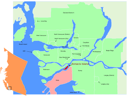
See Annacis Island, Delta, on the map
Public Transit to Annacis Island in Delta
Wondering how to get to Annacis Island in Delta, Canada? Moovit helps you find the best way to get to Annacis Island with step-by-step directions from the nearest public transit station.
Moovit provides free maps and live directions to help you navigate through your city. View schedules, routes, timetables, and find out how long does it take to get to Annacis Island in real time.
Looking for the nearest stop or station to Annacis Island? Check out this list of stops closest to your destination: Westbound Cliveden Ave @ Chester Rd; Northbound Hwy 91 Offramp @ Cliveden Ave; 22nd Street Station.
Bus: 104, 301, 388, 340.SkyTrain: EXPO LINE.
Want to see if there’s another route that gets you there at an earlier time? Moovit helps you find alternative routes or times. Get directions from and directions to Annacis Island easily from the Moovit App or Website.
We make riding to Annacis Island easy, which is why over 1.5 million users, including users in Delta, trust Moovit as the best app for public transit. You don’t need to download an individual bus app or train app, Moovit is your all-in-one transit app that helps you find the best bus time or train time available.
For information on prices of bus and SkyTrain, costs and ride fares to Annacis Island, please check the Moovit app.
Use the app to navigate to popular places including to the airport, hospital, stadium, grocery store, mall, coffee shop, school, college, and university.
Annacis Island Address: Annacis Island, Delta, BC, Canada street in Delta
Attractions near Annacis Island
Lotus Led Lights,Shaw Donair Bites Ltd,660 Annance Ct,H&M Annacis Island,AFOD,Pepsi Co Beverages Canada,540 Chester Road,Mcdonald's,TRC,Annacis Island,Fraserway Rv Delta,Cliveden Avenue,The Original Cakerie Ltd.,Exit 11,Wholebrand Food Management,Buur Fashion Canada LTD,Amazon Fulfillment Center-YVR2,Amazon.ca Fulfillment Center,YVR2 Amazon Fulfillment Center,450 Derwent PlaceHow to get to popular attractions in Delta with public transit
1150 Station Street, Vancouver,Yvr Airport, Richmond,walmart Langley, Langley,3480 Gilmore Way, Burnaby,Bob Featherstone Strawberries, Richmond,Grand Villa Casino Hotel and Conference Centre, Burnaby,2775 Laurel Street, Vancouver,287 Nelson's Court, New Westminster,Hampton Inn and Suites Downtown Vancouver, Vancouver,Walmart, Surrey,Steveston, Richmond,Juan De Fuca Recreation Centre, Colwood,Fraser Health Authority Langley Memorial Hospital, Langley District Municipality,McArthurGlen Designer Outlet Vancouver, Richmond,Steveston Village, Richmond,Eagle Ridge Hospital & Health Care, Port Moody,Emily Carr University, Vancouver,Moda Hotel, Vancouver,Nanaimo Regional General Hospital, Nanaimo,Alexander College, BurnabyGet around Southwest British Columbia by public transit!
Traveling around Southwest British Columbia has never been so easy. See step by step directions as you travel to any attraction, street or major public transit station. View bus and train schedules, arrival times, service alerts and detailed routes on a map, so you know exactly how to get to anywhere in Southwest British Columbia.
When traveling to any destination around Southwest British Columbia use Moovit's Live Directions with Get Off Notifications to know exactly where and how far to walk, how long to wait for your line, and how many stops are left. Moovit will alert you when it's time to get off — no need to constantly re-check whether yours is the next stop.
Wondering how to use public transit in Southwest British Columbia or how to pay for public transit in Southwest British Columbia? Moovit public transit app can help you navigate your way with public transit easily, and at minimum cost. It includes public transit fees, ticket prices, and costs. Looking for a map of Southwest British Columbia public transit lines? Moovit public transit app shows all public transit maps in Southwest British Columbia with all Bus, Train, SkyTrain and Ferry routes and stops on an interactive map.
Southwest British Columbia has 4 transit type(s), including: Bus, Train, SkyTrain and Ferry, operated by several transit agencies, including TransLink, False Creek Ferries, BC Ferries, Aquabus, BC Transit - Central Fraser Valley Transit System, BCTransit, BC Transit - Comox Valley Transit System, BC Transit - Aggasiz-Harrison and Hope Transit System, BC Transit - Chilliwack Transit System, BC Transit - Squamish, BC Transit - Whistler Transit System, BC Transit - Cowichan Valley Regional Transit System, BC Transit - Campbell River Transit System, BC Transit - Powell River Regional Transit System, BC Transit - Sunshine Coast Transit System