Directions to Auto Posto Procar (Santa Cândida) with public transportation
The following transit lines have routes that pass near Auto Posto Procar
How to get to Auto Posto Procar by bus?
Click on the bus route to see step by step directions with maps, line arrival times and updated time schedules.
From Avenida Água Verde, Água Verde
48 minFrom Estação Tubo Brigadeiro Franco, Centro
42 minFrom Avenida Manoel Ribas, Santa Felicidade
69 minFrom Rua Luiz França, Cajuru
56 minFrom Rua José de Alencar, Alto Da Rua XV
30 minFrom Rua Professor Brandão, Alto Da Rua XV
30 minFrom Maternidade Curitiba, Água Verde
52 minFrom Electrolux Do Brasil Sa, Guabirotuba
62 minFrom Templo Maior (IURD), Rebouças
39 min
Bus stops near Auto Posto Procar in Santa Cândida
- Joaquim Nabuco, 3 min walk,VIEW
- Av. Paraná, 4420, 3 min walk,VIEW
- R. João Gbur, 1300, 3 min walk,VIEW
- Av. Paraná, 4955, 6 min walk,VIEW
- R. Edmundo Alberto Mercer, 682, 6 min walk,VIEW
- Av. Paraná, 4818, 7 min walk,VIEW
- Terminal Santa Cândida, 7 min walk,VIEW
- Rua José Antônio Leprevost 478-570, 8 min walk,VIEW
- R. Coronel Wallace Scott Murray, 493, 9 min walk,VIEW
Bus lines to Auto Posto Procar in Santa Cândida
- 203 SANTA CÂNDIDA / CAPÃO RASO, Terminal Capão Raso → Terminal Santa Cândida,VIEW
- 209 MAD. SANTA CÂNDIDA / CAPÃO RASO, Terminal Santa Cândida → Terminal Capão Raso (via Praça Rui Barbosa),VIEW
- S01 ROÇA GRANDE / GUADALUPE (VIA SANTA CÂNDIDA), ROÇA GRANDE / GUADALUPE (VIA SANTA CÂNDIDA),VIEW
- B72 COLOMBO / GUADALUPE (VIA T. ROÇA GRANDE), COLOMBO / GUADALUPE (via T. ROÇA GRANDE),VIEW
- B73 JARDIM OSASCO / GUADALUPE, JARDIM OSASCO / GUADALUPE,VIEW
- B76 SÃO SEBASTIÃO / GUADALUPE, SÃO SEBASTIÃO / GUADALUPE,VIEW
- B78 SÃO GABRIEL / GUADALUPE, SÃO GABRIEL / GUADALUPE,VIEW
- S89 SÃO SEBASTIÃO / GUADALUPE (VIA SÃO GABRIEL), SÃO SEBASTIÃO / GUADALUPE (via SÃO GABRIEL),VIEW
- B11 MARACANÃ / SANTA CÂNDIDA, Terminal Santa Cândida → Terminal Maracanã,VIEW
- 214 TINGUI, Terminal Santa Cândida → Terminal Cabral,VIEW
- B39 CAMPO ALTO / SANTA CÂNDIDA, Terminal Santa Cândida ↺ Campo Alto / Capela do Atuba (Circular),VIEW
- B58 MARACANÃ / SANTA CÂNDIDA (CIRCULAR), Terminal Santa Cândida ↺ Terminal Maracanã (Circular),VIEW
- 231 BANESTADO / CALIFÓRNIA, Califórnia → Terminal Santa Cândida,VIEW
- 233 OLARIA, Terminal Santa Cândida ↻ Olaria (Circular),VIEW
- 237 PARQUE ATUBA, Terminal Santa Cândida ↺ Parque Atuba (Circular),VIEW
- 030 INTERBAIRROS III, Terminal Bairro Alto → Terminal Santa Cândida,VIEW
- S31 ROÇA GRANDE / SANTA CÂNDIDA, Terminal Roça Grande → Terminal Santa Cândida,VIEW
- B57 CAMPO ALTO / SANTA CÂNDIDA, Terminal Santa Cândida ↺ Terminal Maracanã (Circular),VIEW
- O69 MAD. QUATRO BARRAS / SANTA CÂNDIDA, Terminal Santa Cândida → Terminal Quatro Barras,VIEW
- 232 ALIANÇA, Aliança → Terminal Santa Cândida,VIEW
What are the closest stations to Auto Posto Procar?
The closest stations to Auto Posto Procar are:
- Joaquim Nabuco is 132 meters away, 3 min walk.
- Av. Paraná, 4420 is 145 meters away, 3 min walk.
- R. João Gbur, 1300 is 147 meters away, 3 min walk.
- Av. Paraná, 4955 is 385 meters away, 6 min walk.
- R. Edmundo Alberto Mercer, 682 is 403 meters away, 6 min walk.
- Av. Paraná, 4818 is 519 meters away, 7 min walk.
- Terminal Santa Cândida is 535 meters away, 7 min walk.
- Rua José Antônio Leprevost 478-570 is 568 meters away, 8 min walk.
- R. Coronel Wallace Scott Murray, 493 is 639 meters away, 9 min walk.
Which bus lines stop near Auto Posto Procar?
These bus lines stop near Auto Posto Procar: 030 INTERBAIRROS III, 203 SANTA CÂNDIDA / CAPÃO RASO, B72 COLOMBO / GUADALUPE (VIA T. ROÇA GRANDE), B76 SÃO SEBASTIÃO / GUADALUPE.
What’s the nearest bus station to Auto Posto Procar in Santa Cândida?
The nearest bus stations to Auto Posto Procar in Santa Cândida are Joaquim Nabuco, Av. Paraná, 4420 and R. João Gbur, 1300. The closest one is a 3 min walk away.
What time is the first bus to Auto Posto Procar in Santa Cândida?
The 209 MAD. SANTA CÂNDIDA / CAPÃO RASO is the first bus that goes to Auto Posto Procar in Santa Cândida. It stops nearby at 3:10 AM.
What time is the last bus to Auto Posto Procar in Santa Cândida?
The 209 MAD. SANTA CÂNDIDA / CAPÃO RASO is the last bus that goes to Auto Posto Procar in Santa Cândida. It stops nearby at 3:11 AM.
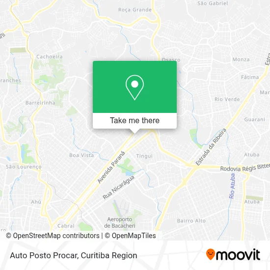
See Auto Posto Procar, Santa Cândida, on the map
Public Transit to Auto Posto Procar in Santa Cândida
Wondering how to get to Auto Posto Procar in Santa Cândida? Moovit helps you find the best way to get to Auto Posto Procar with step-by-step directions from the nearest public transit station.
Moovit provides free maps and live directions to help you navigate through your city. View schedules, routes, timetables, and find out how long does it take to get to Auto Posto Procar in real time.
Looking for the nearest stop or station to Auto Posto Procar? Check out this list of stops closest to your destination: Joaquim Nabuco; Av. Paraná; R. João Gbur; Av. Paraná; R. Edmundo Alberto Mercer; Av. Paraná; Terminal Santa Cândida; Rua José Antônio Leprevost 478-570; R. Coronel Wallace Scott Murray.
Bus: 030 INTERBAIRROS III, 203 SANTA CÂNDIDA / CAPÃO RASO, B72 COLOMBO / GUADALUPE (VIA T. ROÇA GRANDE), B76 SÃO SEBASTIÃO / GUADALUPE, S01 ROÇA GRANDE / GUADALUPE (VIA SANTA CÂNDIDA), B73 JARDIM OSASCO / GUADALUPE, B78 SÃO GABRIEL / GUADALUPE, 209 MAD. SANTA CÂNDIDA / CAPÃO RASO, B11 MARACANÃ / SANTA CÂNDIDA, 214 TINGUI, B39 CAMPO ALTO / SANTA CÂNDIDA, B58 MARACANÃ / SANTA CÂNDIDA (CIRCULAR), 231 BANESTADO / CALIFÓRNIA, 233 OLARIA, 237 PARQUE ATUBA.
Want to see if there’s another route that gets you there at an earlier time? Moovit helps you find alternative routes or times. Get directions from and directions to Auto Posto Procar easily from the Moovit App or Website.
We make riding to Auto Posto Procar easy, which is why over 1.5 million users, including users in Santa Cândida, trust Moovit as the best app for public transit. You don’t need to download an individual bus app or train app, Moovit is your all-in-one transit app that helps you find the best bus time or train time available.
For information on prices of bus, costs and ride fares to Auto Posto Procar, please check the Moovit app.
Use the app to navigate to popular places including to the airport, hospital, stadium, grocery store, mall, coffee shop, school, college, and university.
Auto Posto Procar Address: Avenida Paraná, 4555 Santa Cândida Curitiba-PR 82620-360 street in Santa Cândida
- It Escola di Danca,
- Ipiranga,
- Ampm,
- Clinica Veterinaria Vida Pet,
- Escola Furacão Bairro Alto,
- Premium Cafeteria,
- Eletrônica Videotécnica Paraná,
- Modeladores Corpo Pele,
- Flg - Comercio de Carnes,
- Center Clean,
- Mabella Modeladores,
- Ponto Firmado Store,
- Ponto Firmado,
- Santa Ajuda Produtos de Limpeza,
- Lanchonete Tentacao,
- Bucanner,
- Scholze Solutions,
- Residencial Stromberg,
- Mascara Pizza Bar,
- Pizzadog
Places Near Auto Posto Procar (Santa Cândida)
- Hospital Angelina Caron, Campina Grande Do Sul,
- Hospital Madalena Sofia, Bairro Alto,
- Hospital do Rocio, Campo,
- Pontifícia Universidade Católica do Paraná (PUCPR), Prado Velho,
- Jockey Plaza Shopping Center, Tarumã,
- Rua General Mário Tourinho, Campina Do Siqueira,
- Parque Barigui, Mercês,
- Shopping Estação, Rebouças,
- Hospital de Clínicas (HC - UFPR), Centro,
- Hhhhh, Fazendinha,
- Hospital Universitário Evangélico de Curitiba, Bigorrilho,
- Hospital Da Cruz Vermelha, Batel,
- Shopping Palladium, Portão,
- Jardim Botânico de Curitiba PR, Centro,
- Hospital Nossa Senhora Das Graças, Mercês,
- Campo Largo, Campo,
- Hospital Erasto Gaertner, Jardim Das Américas,
- Arena Da Baixada - Curitiba,
- Park Shopping Barigüi, Mossunguê,
- Rua Martim Afonso 558, Mercês
How to get to popular places in Curitiba Region with public transit
Get around Santa Cândida by public transit!
Traveling around Santa Cândida has never been so easy. See step by step directions as you travel to any attraction, street or major public transit station. View bus and train schedules, arrival times, service alerts and detailed routes on a map, so you know exactly how to get to anywhere in Santa Cândida.
When traveling to any destination around Santa Cândida use Moovit's Live Directions with Get Off Notifications to know exactly where and how far to walk, how long to wait for your line, and how many stops are left. Moovit will alert you when it's time to get off — no need to constantly re-check whether yours is the next stop.
Wondering how to use public transit in Santa Cândida or how to pay for public transit in Santa Cândida? Moovit public transit app can help you navigate your way with public transit easily, and at minimum cost. It includes public transit fees, ticket prices, and costs. Looking for a map of Santa Cândida public transit lines? Moovit public transit app shows all public transit maps in Santa Cândida with all Bus and Cable Car routes and stops on an interactive map.
Curitiba Region has 2 transit type(s), including: Bus and Cable Car, operated by several transit agencies, including Sistema Integrado de Mobilidade (URBS), Sistema Integrado de Mobilidade (AMEP), URBS (Cartões bancários e Dinheiro), URBS (Cartões bancários / Cartão URBS), AMEP (Cartões bancários / Cartão MetroCard), AMEP (Cartões bancários / Cartão MetroCard / Dinheiro), Viação Colombo (Dinheiro), TRIAR (Cartão TRIAR / Dinheiro), Empresa Curitiba Cerro Azul (Dinheiro), Expresso Nossa Senhora da Penha (Dinheiro), Empresa Campo Alto Tijucas (Dinheiro), Auto Viação São José (Cartão VEM / Dinheiro), BRT S/A (Cartão VEM / Dinheiro), TransPiedade (Cartão Cidadão / Dinheiro) and Oceânica Sul (Cartão Transporte / Dinheiro)
Public transit lines with stations closest to Auto Posto Procar in Santa Cândida
Bus lines with stations closest to Auto Posto Procar in Santa Cândida
R. João Gbur, 1300
 S01 ROÇA GRANDE / GUADALUPE (VIA SANTA CÂNDIDA)ROÇA GRANDE / GUADALUPE (VIA SANTA CÂNDIDA)
- B72 COLOMBO / GUADALUPE (VIA T. ROÇA GRANDE)COLOMBO / GUADALUPE (via T. ROÇA GRANDE)
- B73 JARDIM OSASCO / GUADALUPEJARDIM OSASCO / GUADALUPE
- B76 SÃO SEBASTIÃO / GUADALUPESÃO SEBASTIÃO / GUADALUPE
- B78 SÃO GABRIEL / GUADALUPESÃO GABRIEL / GUADALUPE