Directions to Aziziye Camii station (Selçuklu) with public transit
The following transit lines have routes that pass near Aziziye Camii
How to get to Aziziye Camii station by bus?
Click on the bus route to see step by step directions with maps, line arrival times and updated time schedules.
Bus stops near Aziziye Camii in Selçuklu
- Üçler Mezarlığı, 6 min walk,
- Mevlana, 6 min walk,
- Rumi, 6 min walk,
- İL Milli Eğitim Müdürlüğü, 7 min walk,
- Kızılay Hastanesi, 8 min walk,
- Piri Esat, 9 min walk,
Light Rail stations near Aziziye Camii in Selçuklu
- Hükümet Meydanı (T36), 21 min walk,
- Alaaddin (T31), 26 min walk,
Bus lines to Aziziye Camii station in Selçuklu
- 3-A, Dere Yeni̇ Yol,
- 14-A, Ahmet Özcan Cad Feti̇h Cad,
- 25-A, Dere Meram Tıp,
- 31-A, Saraçoğlu,
- 31-B, Saraçoğlu Erler,
- 31-C, Saraçoğlu Altınoluk Kanal,
- 31-D, Saraçoğlu Kanal Altınoluk,
- 43-A, Pınarbaşı,
- 43-B, Pınarbaşı Sarıcalar Çaltı,
- 50-A, Sakyatan Bakırtolu Şatır,
- 81-A, Ortakonak Di̇vanlar,
- 92-A, Dedemli̇ Çarıklar,
- 92-B, Çarıklar Dedemli̇,
- 99-A, Tatköy,
- 103-A, Feti̇h Cad Aykent 2. Organi̇ze,
- 105-A, Sarayköy Sulutas,
- 111-A, Tömek,
- 8-A, Kovanağzı,
- 20-A, Uzunharmanlar,
- 34-A, Bi̇li̇m Merkezi̇,
What are the closest stations to Aziziye Camii?
The closest stations to Aziziye Camii are:
- Üçler Mezarlığı is 379 meters away, 6 min walk.
- Mevlana is 420 meters away, 6 min walk.
- Rumi is 437 meters away, 6 min walk.
- İL Milli Eğitim Müdürlüğü is 506 meters away, 7 min walk.
- Kızılay Hastanesi is 529 meters away, 8 min walk.
- Piri Esat is 664 meters away, 9 min walk.
- Hükümet Meydanı (T36) is 1624 meters away, 21 min walk.
- Alaaddin (T31) is 1976 meters away, 26 min walk.
Which bus lines stop near Aziziye Camii?
These bus lines stop near Aziziye Camii: 103-A, 14-A, 3-A, 41-A, 44-A, 44-B, 81-A, 92-A.
Which light rail line stops near Aziziye Camii?
150-A (Kültürpark)
What’s the nearest light rail station to Aziziye Camii in Selçuklu?
The nearest light rail station to Aziziye Camii in Selçuklu is Hükümet Meydanı (T36). It’s a 21 min walk away.
What’s the nearest bus stop to Aziziye Camii in Selçuklu?
The nearest bus stops to Aziziye Camii in Selçuklu are Üçler Mezarlığı, Mevlana and Rumi. The closest one is a 6 min walk away.
What time is the first light rail to Aziziye Camii in Selçuklu?
The 153-A is the first light rail that goes to Aziziye Camii in Selçuklu. It stops nearby at 4:00 AM.
What time is the last light rail to Aziziye Camii in Selçuklu?
The 153-A is the last light rail that goes to Aziziye Camii in Selçuklu. It stops nearby at 1:40 AM.
What time is the first bus to Aziziye Camii in Selçuklu?
The 31-C is the first bus that goes to Aziziye Camii in Selçuklu. It stops nearby at 6:00 AM.
What time is the last bus to Aziziye Camii in Selçuklu?
The 31-B is the last bus that goes to Aziziye Camii in Selçuklu. It stops nearby at 1:39 AM.
See Aziziye Camii, Selçuklu, on the map
Public Transit to Aziziye Camii in Selçuklu
Wondering how to get to Aziziye Camii in Selçuklu, Turkey? Moovit helps you find the best way to get to Aziziye Camii with step-by-step directions from the nearest public transit station.
Moovit provides free maps and live directions to help you navigate through your city. View schedules, routes, timetables, and find out how long does it take to get to Aziziye Camii in real time.
Looking for the nearest stop or station to Aziziye Camii? Check out this list of stops closest to your destination: Üçler Mezarlığı; Mevlana; Rumi; İL Milli Eğitim Müdürlüğü; Kızılay Hastanesi; Piri Esat; Hükümet Meydanı (T36); Alaaddin (T31).
Bus: 103-A, 14-A, 3-A, 41-A, 44-A, 44-B, 81-A, 92-A, 25-A, 31-A, 31-B, 8-A, 20-A, 34-A, 34-B, 38-B, 16-A, 21-A, 23-A, 24-A, 24-B, 19-A, 123-A, 65-A, 94-A, 94-B.Light Rail: 150-A.
Want to see if there’s another route that gets you there at an earlier time? Moovit helps you find alternative routes or times. Get directions from and directions to Aziziye Camii easily from the Moovit App or Website.
We make riding to Aziziye Camii easy, which is why over 1.5 million users, including users in Selçuklu, trust Moovit as the best app for public transit. You don’t need to download an individual bus app or train app, Moovit is your all-in-one transit app that helps you find the best bus time or train time available.
For information on prices of bus and light rail, costs and ride fares to Aziziye Camii, please check the Moovit app.
Use the app to navigate to popular places including to the airport, hospital, stadium, grocery store, mall, coffee shop, school, college, and university.
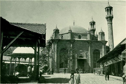
Aziziye Camii Address: Türbe Caddesi street in Selçuklu
The Aziziye Mosque (Turkish: Aziziye Camii) is an Ottoman mosque in Konya, Turkey. It is well known for the columned balcony of its minaret, an architectural feature rarely seen in Turkish mosques.Wiki
Places Near Aziziye Camii (Selçuklu)
How to get to popular places in Konya with public transit
Get around Selçuklu by public transit!
Traveling around Selçuklu has never been so easy. See step by step directions as you travel to any attraction, street or major public transit station. View bus and train schedules, arrival times, service alerts and detailed routes on a map, so you know exactly how to get to anywhere in Selçuklu.
When traveling to any destination around Selçuklu use Moovit's Live Directions with Get Off Notifications to know exactly where and how far to walk, how long to wait for your line, and how many stops are left. Moovit will alert you when it's time to get off — no need to constantly re-check whether yours is the next stop.
Wondering how to use public transit in Selçuklu or how to pay for public transit in Selçuklu? Moovit public transit app can help you navigate your way with public transit easily, and at minimum cost. It includes public transit fees, ticket prices, and costs. Looking for a map of Selçuklu public transit lines? Moovit public transit app shows all public transit maps in Selçuklu with all Bus and Light Rail routes and stops on an interactive map.
Konya has 2 transit type(s), including: Bus and Light Rail, operated by several transit agencies, including ATUS and Havaş