See Bahnhof Berlin-Charlottenburg on the map
Directions to Bahnhof Berlin-Charlottenburg with public transportation
The following transit lines have routes that pass near Bahnhof Berlin-Charlottenburg
 Train:
 - Subway:
- Bus:
How to get to Bahnhof Berlin-Charlottenburg by bus?
Click on the bus route to see step by step directions with maps, line arrival times and updated time schedules.
How to get to Bahnhof Berlin-Charlottenburg by train?
Click on the train route to see step by step directions with maps, line arrival times and updated time schedules.
How to get to Bahnhof Berlin-Charlottenburg by subway?
Click on the subway route to see step by step directions with maps, line arrival times and updated time schedules.
Train stations near Bahnhof Berlin-Charlottenburg
- S Charlottenburg Bhf,1 min walk,
Bus stations near Bahnhof Berlin-Charlottenburg
- S Charlottenburg Bhf,2 min walk,
- S Charlottenburg/Gervinusstr.,2 min walk,
- Kaiser-Friedrich-Str./Kantstr.,5 min walk,
- U Adenauerplatz,9 min walk,
Bus lines to Bahnhof Berlin-Charlottenburg
- X49,Im Spektefeld/Schulzentrum,
- 309,U Wilmersdorfer Str./S Charlottenburg,
- N7,U Adenauerplatz,
- 109,U Jakob-Kaiser-Platz,
- X34,Hertzallee,
- M49,Savignyplatz,
- N10,Rathaus Zehlendorf,
- X10,Teltow Rammrath-Brücke,
- M19,Hagenplatz,
- M29,Roseneck,
What are the closest stations to Bahnhof Berlin-Charlottenburg?
The closest stations to Bahnhof Berlin-Charlottenburg are:
- S Charlottenburg Bhf is 14 meters away, 1 min walk.
- S Charlottenburg/Gervinusstr. is 131 meters away, 2 min walk.
- Kaiser-Friedrich-Str./Kantstr. is 292 meters away, 5 min walk.
- U Adenauerplatz is 620 meters away, 9 min walk.
Which train lines stop near Bahnhof Berlin-Charlottenburg?
These train lines stop near Bahnhof Berlin-Charlottenburg: RB23, RE1, RE2, RE7, S5, S7, S9.
Which subway line stops near Bahnhof Berlin-Charlottenburg?
U7
Which bus lines stop near Bahnhof Berlin-Charlottenburg?
These bus lines stop near Bahnhof Berlin-Charlottenburg: 109, 110, M29, X10.
What’s the nearest train station to Bahnhof Berlin-Charlottenburg?
The nearest train station to Bahnhof Berlin-Charlottenburg is S Charlottenburg Bhf. It’s a 1 min walk away.
What’s the nearest bus stop to Bahnhof Berlin-Charlottenburg?
The nearest bus stops to Bahnhof Berlin-Charlottenburg are S Charlottenburg Bhf and S Charlottenburg/Gervinusstr.. The closest one is a 2 min walk away.
What time is the first train to Bahnhof Berlin-Charlottenburg?
The S9 is the first train that goes to Bahnhof Berlin-Charlottenburg. It stops nearby at 3:02 AM.
What time is the last train to Bahnhof Berlin-Charlottenburg?
The RE8 is the last train that goes to Bahnhof Berlin-Charlottenburg. It stops nearby at 3:24 AM.
What time is the first bus to Bahnhof Berlin-Charlottenburg?
The M29 is the first bus that goes to Bahnhof Berlin-Charlottenburg. It stops nearby at 3:02 AM.
What time is the last bus to Bahnhof Berlin-Charlottenburg?
The N7 is the last bus that goes to Bahnhof Berlin-Charlottenburg. It stops nearby at 3:49 AM.
How much is the bus fare to Bahnhof Berlin-Charlottenburg?
The bus fare to Bahnhof Berlin-Charlottenburg costs about €2.40 - €3.50.
How much is the train fare to Bahnhof Berlin-Charlottenburg?
The train fare to Bahnhof Berlin-Charlottenburg costs about €1.80 - €4.40.
How much is the subway fare to Bahnhof Berlin-Charlottenburg?
The subway fare to Bahnhof Berlin-Charlottenburg costs about €2.40 - €3.50.
See Bahnhof Berlin-Charlottenburg on the map
Public Transportation to Bahnhof Berlin-Charlottenburg
Wondering how to get to Bahnhof Berlin-Charlottenburg, Germany? Moovit helps you find the best way to get to Bahnhof Berlin-Charlottenburg with step-by-step directions from the nearest public transit station.
Moovit provides free maps and live directions to help you navigate through your city. View schedules, routes, timetables, and find out how long does it take to get to Bahnhof Berlin-Charlottenburg in real time.
Looking for the nearest stop or station to Bahnhof Berlin-Charlottenburg? Check out this list of stops closest to your destination: S Charlottenburg Bhf; S Charlottenburg/Gervinusstr.; Kaiser-Friedrich-Str./Kantstr.; U Adenauerplatz.
Train:Subway:Bus:
Want to see if there’s another route that gets you there at an earlier time? Moovit helps you find alternative routes or times. Get directions from and directions to Bahnhof Berlin-Charlottenburg easily from the Moovit App or Website.
We make riding to Bahnhof Berlin-Charlottenburg easy, which is why over 1.5 million users, including users in Charlottenburg, trust Moovit as the best app for public transit. You don’t need to download an individual bus app or train app, Moovit is your all-in-one transit app that helps you find the best bus time or train time available.
For information on prices of train, bus and subway, costs and ride fares to Bahnhof Berlin-Charlottenburg, please check the Moovit app.
Use the app to navigate to popular places including to the airport, hospital, stadium, grocery store, mall, coffee shop, school, college, and university.
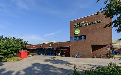
Bahnhof Berlin-Charlottenburg Address: Stuttgarter Platz 36 street in Charlottenburg
Attractions near Bahnhof Berlin-Charlottenburg
RE 4352 nach Rostock Hbf,RE 3729,Stuttgarter Platz 36,S-Bhf. Charlottenburg / Bhf. Berlin-Charlottenburg DB,Stuttgarter Platz,Gleis 3/4,Postkasten in Gervinusstraße,Bahnhof Berlin-Charlottenburg (S-Bahn-Charlottenburg),New Line Optik,Gleis 1/2,H Kaiser-Friedrich-Straße / Kantstraße,Hotel Atrium Charlottenburg,Dahlmannstraße,Happy Go Lucky Hotel Hostel Berlin,Victoria Sturm,Happy Go Lucky Hotel,Russisk Butik,Victoria Secret,Sex-Kino Monte Carlo,Kaiser-Friedrich-Straße 51How to get to popular attractions in Charlottenburg with public transit
Weihnachtszauber Gendarmenmarkt, Berlin Mitte,Schlossplatz, Köpenick,Hatoki, Niederschönhausen,Sommerbad Wilmersdorf, Schmargendorf,Deko Behrendt, Schöneberg,Kleingartenanlage Kohlhasenbrück, Wannsee,ITDZ, Wilmersdorf,Wasserturm Charlottenburg, Westend,Straussee, Strausberg,Kadewe, Schöneberg,S Lichterfelde Süd, Lichterfelde,Shi Shan China Restaurant, Stahnsdorf,mobile.de, Kleinmachnow,U Franz-Neumann-Platz, Reinickendorf,PCK Raffinerie GmbH, Uckermark,PAREXEL International GmbH, Charlottenburg,Lübars, Lübars,SAP Innovation Center, Potsdam,Steinbergpark, Tegel,REWE CITY, CharlottenburgGet around Charlottenburg by public transit!
Traveling around Charlottenburg has never been so easy. See step by step directions as you travel to any attraction, street or major public transit station. View bus and train schedules, arrival times, service alerts and detailed routes on a map, so you know exactly how to get to anywhere in Charlottenburg.
When traveling to any destination around Charlottenburg use Moovit's Live Directions with Get Off Notifications to know exactly where and how far to walk, how long to wait for your line, and how many stops are left. Moovit will alert you when it's time to get off — no need to constantly re-check whether yours is the next stop.
Wondering how to use public transit in Charlottenburg or how to pay for public transit in Charlottenburg? Moovit public transit app can help you navigate your way with public transit easily, and at minimum cost. It includes public transit fees, ticket prices, and costs. Looking for a map of Charlottenburg public transit lines? Moovit public transit app shows all public transit maps in Charlottenburg with all train, bus or subway routes and stops on an interactive map.
Charlottenburg has 3 transit type(s), including: train, bus or subway, operated by several transit agencies, including BVG, BVG, BVG, VBB, S-Bahn, Cottbusverkehr, Schöneicher Rüdersdorfer Straßenbahn, Strausberger Eisenbahn GmbH, Stadtverkehrsgesellschaft Tram, Verkehrsbetriebe Brandenburg, Verkehrsverbund Potsdam, BVG, DB Regio Bus, Barnimer Busgesellschaft and Busverkehr Oder-Spree GmbH