See Baystreet, Montclair, Nj, on the map
Directions to Baystreet (Montclair, Nj) with public transportation
The following transit lines have routes that pass near Baystreet
 Bus:
Bus: - Train:
How to get to Baystreet by bus?
Click on the bus route to see step by step directions with maps, line arrival times and updated time schedules.
How to get to Baystreet by train?
Click on the train route to see step by step directions with maps, line arrival times and updated time schedules.
Bus stations near Baystreet in Montclair, Nj
- Park St at Walnut St#,2 min walk,
- Park St at Bloomfield Ave,5 min walk,
- Bloomfield Ave at Park St,6 min walk,
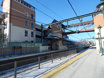
Train stations near Baystreet in Montclair, Nj
- Bay Street,21 min walk,
Bus lines to Baystreet in Montclair, Nj
- 28,Montclair Elm Street,
- 101,New York Express,
- 34,34p Newark Penn Station,
- 97,Crosstown East Orange Crosstown Central Ave,
- 11,Wayne Willowbrook,
- 29,Bloomfield Ave Montclair,
What are the closest stations to Baystreet?
The closest stations to Baystreet are:
- Park St at Walnut St# is 84 yards away, 2 min walk.
- Park St at Bloomfield Ave is 351 yards away, 5 min walk.
- Bloomfield Ave at Park St is 482 yards away, 6 min walk.
- Bay Street is 1784 yards away, 21 min walk.
Which bus lines stop near Baystreet?
These bus lines stop near Baystreet: 28, 29, 34.
Which train line stops near Baystreet?
ML
What’s the nearest train station to Baystreet in Montclair, Nj?
The nearest train station to Baystreet in Montclair, Nj is Bay Street. It’s a 21 min walk away.
What’s the nearest bus stop to Baystreet in Montclair, Nj?
The nearest bus stop to Baystreet in Montclair, Nj is Park St at Walnut St#. It’s a 2 min walk away.
What time is the first train to Baystreet in Montclair, Nj?
The ML is the first train that goes to Baystreet in Montclair, Nj. It stops nearby at 4:50 AM.
What time is the last train to Baystreet in Montclair, Nj?
The ML is the last train that goes to Baystreet in Montclair, Nj. It stops nearby at 1:16 AM.
What time is the first bus to Baystreet in Montclair, Nj?
The 29 is the first bus that goes to Baystreet in Montclair, Nj. It stops nearby at 4:30 AM.
What time is the last bus to Baystreet in Montclair, Nj?
The 29 is the last bus that goes to Baystreet in Montclair, Nj. It stops nearby at 1:39 AM.
How much is the subway fare to Baystreet?
The subway fare to Baystreet costs about $2.75.
How much is the train fare to Baystreet?
The train fare to Baystreet costs about $2.25 - $7.75.
How much is the bus fare to Baystreet?
The bus fare to Baystreet costs about $2.75.
See Baystreet, Montclair, Nj, on the map
Public Transit to Baystreet in Montclair, Nj
Wondering how to get to Baystreet in Montclair, Nj, United States? Moovit helps you find the best way to get to Baystreet with step-by-step directions from the nearest public transit station.
Moovit provides free maps and live directions to help you navigate through your city. View schedules, routes, timetables, and find out how long does it take to get to Baystreet in real time.
Looking for the nearest stop or station to Baystreet? Check out this list of stops closest to your destination: Park St at Walnut St#; Park St at Bloomfield Ave; Bloomfield Ave at Park St; Bay Street.
Bus:Train:
Want to see if there’s another route that gets you there at an earlier time? Moovit helps you find alternative routes or times. Get directions from and directions to Baystreet easily from the Moovit App or Website.
We make riding to Baystreet easy, which is why over 1.5 million users, including users in Montclair, Nj, trust Moovit as the best app for public transit. You don’t need to download an individual bus app or train app, Moovit is your all-in-one transit app that helps you find the best bus time or train time available.
For information on prices of bus, train and subway, costs and ride fares to Baystreet, please check the Moovit app.
Use the app to navigate to popular places including to the airport, hospital, stadium, grocery store, mall, coffee shop, school, college, and university.
Baystreet Address: 205 Claremont Ave Montclair, NJ 07042 street in Montclair, Nj
Attractions near Baystreet
Montclair Recreation,Montclair Celebrates July 4th,Cresentbay,Montclair Township Hall,Crescent Office,Upright Africa,Montclair Township,Gail Mentor Realtor,Saida Clarke,Bynext,Goodideazs,Dr. Lisa Cadoo,Alexis Sweeney, Nurse Practioner,Bloomfield Avenue,Janas Jammy,Raphael Paisner,Dyer, Frank J PHD,USPS Collection Box - Blue Box,Innovative Acupuncture,Bennet D Zurofsky Attorney-at-LawHow to get to popular attractions in Montclair, Nj with public transit
The Tippler, Manhattan,Doughnut Plant, Manhattan,MTA Subway - Fulton St (A / C/J / Z/2 / 3/4 / 5), Manhattan,Shake Shack, Manhattan,NJT - New Brunswick Station (NEC), New Brunswick, Nj,Nathan's Famous,Cookshop, Manhattan,Tom & Jerry's, Manhattan,Joe's Shanghai 鹿嗚春, Manhattan,Culture Espresso, Manhattan,The Dead Rabbit, Manhattan,Newark Liberty International Airport (EWR), Newark, Nj,LIRR - Huntington Station, Huntington Station, Ny,Burger Joint, Manhattan,Ferrara Bakery, Manhattan,Woorijip, Manhattan,Caesars Atlantic City Hotel and Casino, Atlantic City, Nj,The Plaza Hotel, Manhattan,Red Rooster, Manhattan,Planet Fitness, QueensGet around Montclair, Nj by public transit!
Traveling around Montclair, Nj has never been so easy. See step by step directions as you travel to any attraction, street or major public transit station. View bus and train schedules, arrival times, service alerts and detailed routes on a map, so you know exactly how to get to anywhere in Montclair, Nj.
When traveling to any destination around Montclair, Nj use Moovit's Live Directions with Get Off Notifications to know exactly where and how far to walk, how long to wait for your line, and how many stops are left. Moovit will alert you when it's time to get off — no need to constantly re-check whether yours is the next stop.
Wondering how to use public transit in Montclair, Nj or how to pay for public transit in Montclair, Nj? Moovit public transit app can help you navigate your way with public transit easily, and at minimum cost. It includes public transit fees, ticket prices, and costs. Looking for a map of Montclair, Nj public transit lines? Moovit public transit app shows all public transit maps in Montclair, Nj with all bus, train or subway routes and stops on an interactive map.
Montclair, Nj has 3 transit type(s), including: bus, train or subway, operated by several transit agencies, including MTA Subway, Metro-North Railroad, LIRR, PATH, Shore Line East, MTA Bus Company, MTA New York City Transit - Express routes, MTA Bus, NJ Transit, NYC Ferry, NICE bus, Bee-Line Bus, NJ Transit Rail, NJ Transit Rail and Norwalk Transit District