Directions to Blink (Somerville) with public transportation
The following transit lines have routes that pass near Blink
 Bus: 112, 83, 85, 87, 109.
- Train: FITCHBURG, RED LINE.
- Subway: GREEN LINE D, GREEN LINE E, RED LINE, GREEN LINE B, GREEN LINE C.
How to get to Blink by bus?
Click on the bus route to see step by step directions with maps, line arrival times and updated time schedules.
From Boston Marriott Long Wharf Hotel Boston, Boston
40 minFrom Dorchester District Court, Boston
87 minFrom Winthrop, Winthrop Town
150 minFrom FOUR POINTS BY SHERATON Boston Newton, Newton
65 minFrom Codman Square, Boston
92 minFrom Waltham, MA, Waltham
70 minFrom AC Hotel by Marriott Boston Cleveland Circle, Boston
57 minFrom Residence Inn by Marriott Boston Downtown/South End, Boston
51 minFrom Roslindale, Boston
87 minFrom Trillium Brewing, Boston
49 min
How to get to Blink by train?
Click on the train route to see step by step directions with maps, line arrival times and updated time schedules.
How to get to Blink by subway?
Click on the subway route to see step by step directions with maps, line arrival times and updated time schedules.
From Boston Marriott Long Wharf Hotel Boston, Boston
39 minFrom Dorchester District Court, Boston
64 minFrom Codman Square, Boston
65 minFrom AC Hotel by Marriott Boston Cleveland Circle, Boston
71 minFrom Residence Inn by Marriott Boston Downtown/South End, Boston
57 minFrom Roslindale, Boston
72 minFrom Trillium Brewing, Boston
48 min
Bus stops near Blink in Somerville
Subway stations near Blink in Somerville
Train station near Blink in Somerville
- Porter, 23 min walk,VIEW
Bus lines to Blink in Somerville
What are the closest stations to Blink?
The closest stations to Blink are:
- Somerville Ave @ Spring St is 187 yards away, 3 min walk.
- Washington St @ Dane St is 428 yards away, 6 min walk.
- Magoun Station is 1460 yards away, 18 min walk.
- Union Square is 1796 yards away, 21 min walk.
- Porter is 1920 yards away, 23 min walk.
Which bus lines stop near Blink?
These bus lines stop near Blink: 112, 83, 85, 87.
Which train line stops near Blink?
FITCHBURG (#409 | Wachusett)
Which subway lines stop near Blink?
These subway lines stop near Blink: GREEN LINE D, GREEN LINE E, RED LINE.
What’s the nearest subway station to Blink in Somerville?
The nearest subway station to Blink in Somerville is Magoun Station. It’s a 18 min walk away.
What’s the nearest train station to Blink in Somerville?
The nearest train station to Blink in Somerville is Porter. It’s a 23 min walk away.
What’s the nearest bus station to Blink in Somerville?
The nearest bus station to Blink in Somerville is Somerville Ave @ Spring St. It’s a 3 min walk away.
What time is the first subway to Blink in Somerville?
The GREEN LINE E is the first subway that goes to Blink in Somerville. It stops nearby at 4:50 AM.
What time is the last subway to Blink in Somerville?
The GREEN LINE E is the last subway that goes to Blink in Somerville. It stops nearby at 2:38 AM.
What time is the first train to Blink in Somerville?
The FITCHBURG is the first train that goes to Blink in Somerville. It stops nearby at 5:47 AM.
What time is the last train to Blink in Somerville?
The FITCHBURG is the last train that goes to Blink in Somerville. It stops nearby at 12:17 AM.
What time is the first bus to Blink in Somerville?
The 109 is the first bus that goes to Blink in Somerville. It stops nearby at 4:56 AM.
What time is the last bus to Blink in Somerville?
The 109 is the last bus that goes to Blink in Somerville. It stops nearby at 1:31 AM.
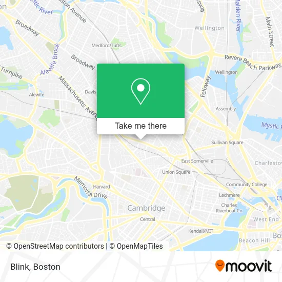
See Blink, Somerville, on the map
Public Transit to Blink in Somerville
Wondering how to get to Blink in Somerville? Moovit helps you find the best way to get to Blink with step-by-step directions from the nearest public transit station.
Moovit provides free maps and live directions to help you navigate through your city. View schedules, routes, timetables, and find out how long does it take to get to Blink in real time.
Looking for the nearest stop or station to Blink? Check out this list of stops closest to your destination: Somerville Ave @ Spring St; Washington St @ Dane St; Magoun Station; Union Square; Porter.
Bus: 112, 83, 85, 87, 109.Train: FITCHBURG, RED LINE.Subway: GREEN LINE D, GREEN LINE E, RED LINE, GREEN LINE B, GREEN LINE C.
Want to see if there’s another route that gets you there at an earlier time? Moovit helps you find alternative routes or times. Get directions from and directions to Blink easily from the Moovit App or Website.
We make riding to Blink easy, which is why over 1.7 million users, including users in Somerville, trust Moovit as the best app for public transit. You don’t need to download an individual bus app or train app, Moovit is your all-in-one transit app that helps you find the best bus time or train time available.
For information on prices of bus, subway and train, costs and ride fares to Blink, please check the Moovit app.
Use the app to navigate to popular places including to the airport, hospital, stadium, grocery store, mall, coffee shop, school, college, and university.
Blink Address: 515 Somerville Ave street in Somerville
- Josephine,
- Cambria Suites,
- Cambria Hotel Boston Somerville,
- Sublime Systems,
- Somerville Bike Kitchen,
- Somernova,
- Igreja de Santo Antonio,
- Scalabrini Centers For Migration in Boston,
- Katerina Kouriati,
- Conway Playground (Conway Park),
- St Anthony Church Bingo,
- Nancy Hellman RNCS,
- Heating Maintenance,
- Aeronaut Brewing,
- Evaptainers,
- Mimi's Chuka Diner,
- Somerville Shop Cannery,
- Tank Design,
- Place of Worship,
- Martin W. Carr School
Places Near Blink (Somerville)
- Isabella Stewart Gardner Museum, Boston,
- Wang Theater, Boston,
- House Of Blues, Boston,
- Cheers, Boston,
- Faneuil Hall, Boston,
- Leader Bank Pavilion (Leader Bank Pavillion), Boston,
- Td Garden, Boston,
- Castle Island, Boston,
- Massachusetts General Hospital, Boston,
- Mgm Music Hall, Boston,
- Prudential Center, Boston,
- North End, Boston,
- Museum Of Science, Boston,
- Seaport District, Boston,
- Boston Children's Hospital, Boston,
- Quincy Market, Boston,
- Boston Common, Boston,
- Boston Medical Center, Boston,
- Boston Convention & Exhibition Center, Boston,
- Wilbur Theatre, Boston
How to get to popular places in Boston with public transit
Get around Somerville by public transit!
Traveling around Somerville has never been so easy. See step by step directions as you travel to any attraction, street or major public transit station. View bus and train schedules, arrival times, service alerts and detailed routes on a map, so you know exactly how to get to anywhere in Somerville.
When traveling to any destination around Somerville use Moovit's Live Directions with Get Off Notifications to know exactly where and how far to walk, how long to wait for your line, and how many stops are left. Moovit will alert you when it's time to get off — no need to constantly re-check whether yours is the next stop.
Wondering how to use public transit in Somerville or how to pay for public transit in Somerville? Moovit public transit app can help you navigate your way with public transit easily, and at minimum cost. It includes public transit fees, ticket prices, and costs. Looking for a map of Somerville public transit lines? Moovit public transit app shows all public transit maps in Somerville with all Bus, Train, Subway and Ferry routes and stops on an interactive map.
Boston has 4 transit type(s), including: Bus, Train, Subway and Ferry, operated by several transit agencies, including MBTA, Southeastern Regional Transit Authority, MetroWest Regional Transit Authority, Rhode Island Public Transit Authority, WRTA, Lowell Regional Transit Authority, Merrimack Valley Transit, Montachusett Regional Transit Authority, Cape Cod Regional Transit Authority, Brockton Area Transit Authority, Martha's Vineyard Transit Authority, the WAVE - Nantucket Regional Transit Authority, GATRA, Cape Ann Transportation Authority and Massport