Directions to Brookline Hills with public transportation
The following transit lines have routes that pass near Brookline Hills
How to get to Brookline Hills by bus?
Click on the bus route to see step by step directions with maps, line arrival times and updated time schedules.
How to get to Brookline Hills by train?
Click on the train route to see step by step directions with maps, line arrival times and updated time schedules.
How to get to Brookline Hills by subway?
Click on the subway route to see step by step directions with maps, line arrival times and updated time schedules.
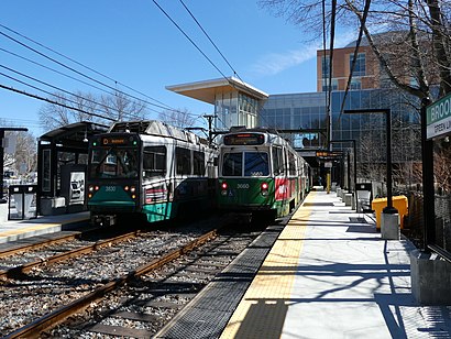
Subway stations near Brookline Hills
- Brookline Hills, 1 min walk,
- Fairbanks Street, 17 min walk,
Bus stations near Brookline Hills
- Cypress St @ Milton Rd, 4 min walk,
- Washington St @ Cypress St, 9 min walk,
Bus lines to Brookline Hills
- 60, Brookline Village,
- 65, Kenmore,
What are the closest stations to Brookline Hills?
The closest stations to Brookline Hills are:
- Brookline Hills is 5 yards away, 1 min walk.
- Cypress St @ Milton Rd is 273 yards away, 4 min walk.
- Washington St @ Cypress St is 713 yards away, 9 min walk.
- Fairbanks Street is 1438 yards away, 17 min walk.
Which bus lines stop near Brookline Hills?
These bus lines stop near Brookline Hills: 39, 47, 60, 66.
Which train line stops near Brookline Hills?
PROVIDENCE/STOUGHTON
Which subway line stops near Brookline Hills?
GREEN LINE D
What’s the nearest subway station to Brookline Hills?
The nearest subway station to Brookline Hills is Brookline Hills. It’s a 1 min walk away.
What’s the nearest bus stop to Brookline Hills?
The nearest bus stop to Brookline Hills is Cypress St @ Milton Rd. It’s a 4 min walk away.
What time is the first subway to Brookline Hills?
The GREEN LINE C is the first subway that goes to Brookline Hills. It stops nearby at 4:55 AM.
What time is the last subway to Brookline Hills?
The GREEN LINE C is the last subway that goes to Brookline Hills. It stops nearby at 1:19 AM.
What time is the first bus to Brookline Hills?
The 60 is the first bus that goes to Brookline Hills. It stops nearby at 4:56 AM.
What time is the last bus to Brookline Hills?
The 60 is the last bus that goes to Brookline Hills. It stops nearby at 12:58 AM.
How much is the subway fare to Brookline Hills?
The subway fare to Brookline Hills costs about $2.40.
How much is the bus fare to Brookline Hills?
The bus fare to Brookline Hills costs about $1.70.
How much is the train fare to Brookline Hills?
The train fare to Brookline Hills costs about $2.40 - $13.25.
See Brookline Hills on the map
Public Transportation to Brookline Hills
Wondering how to get to Brookline Hills, United States? Moovit helps you find the best way to get to Brookline Hills with step-by-step directions from the nearest public transit station.
Moovit provides free maps and live directions to help you navigate through your city. View schedules, routes, timetables, and find out how long does it take to get to Brookline Hills in real time.
Looking for the nearest stop or station to Brookline Hills? Check out this list of stops closest to your destination: Brookline Hills; Cypress St @ Milton Rd; Washington St @ Cypress St; Fairbanks Street.
Bus: 39, 47, 60, 66, 65.Train: PROVIDENCE/STOUGHTON.Subway: GREEN LINE D, GREEN LINE C.
Want to see if there’s another route that gets you there at an earlier time? Moovit helps you find alternative routes or times. Get directions from and directions to Brookline Hills easily from the Moovit App or Website.
We make riding to Brookline Hills easy, which is why over 1.5 million users, including users in Brookline, trust Moovit as the best app for public transit. You don’t need to download an individual bus app or train app, Moovit is your all-in-one transit app that helps you find the best bus time or train time available.
For information on prices of bus, subway and train, costs and ride fares to Brookline Hills, please check the Moovit app.
Use the app to navigate to popular places including to the airport, hospital, stadium, grocery store, mall, coffee shop, school, college, and university.
Brookline Hills Address: Tappan Street Extension street in Brookline
Attractions near Brookline Hills
Brookline Hills Parking Lot,BWPO,Atlantic Heating & Air Conditioning,RTN Federal Credit Union - Medical Area Division,Brookline High School Alumni Association,ATM,RTN Realty Advisors,Credit Union 1,Mafcu Credit Union,Appliance Works,GFT,Brookline Orthodontic Associates,Trung O D,Recreational Services League,New England Buddhist Center,Sgi USA (Boston Sgi Culture Center),Sgi USA,Brookline Tile & Stone,Powell Peralta Pro Cab Ban,Skate BostonHow to get to popular attractions in Brookline with public transit
Cape Air: Terminal C, Boston,Braintree, MA, Braintree Town,The Institute Of Contemporary Art, Boston,Flynn Cruiseport Boston, Boston,Beth Israel Deaconess Hospital-Milton, Milton,Tufts University, Medford,Hilton Boston/Dedham, Dedham,Children's Hospital, Boston,Samuel Adams Brewery, Boston,Hanscom AFB,100 Hancock St, Quincy,Dolphin Day Surgery Waiting Area, Weymouth Town,Market Basket, Revere,10 Causeway St, Boston,South Boston, Boston,Back Bay Station, Boston,Franklin Park Zoo, Boston,Copley Plaza Hotel, Boston,Babson College, Wellesley,Reggie Lewis Athletic Center, BostonGet around Boston by public transit!
Traveling around Boston has never been so easy. See step by step directions as you travel to any attraction, street or major public transit station. View bus and train schedules, arrival times, service alerts and detailed routes on a map, so you know exactly how to get to anywhere in Boston.
When traveling to any destination around Boston use Moovit's Live Directions with Get Off Notifications to know exactly where and how far to walk, how long to wait for your line, and how many stops are left. Moovit will alert you when it's time to get off — no need to constantly re-check whether yours is the next stop.
Wondering how to use public transit in Boston or how to pay for public transit in Boston? Moovit public transit app can help you navigate your way with public transit easily, and at minimum cost. It includes public transit fees, ticket prices, and costs. Looking for a map of Boston public transit lines? Moovit public transit app shows all public transit maps in Boston with all Bus, Train, Subway and Ferry routes and stops on an interactive map.
Boston has 4 transit type(s), including: Bus, Train, Subway and Ferry, operated by several transit agencies, including MBTA, Southeastern Regional Transit Authority, MetroWest Regional Transit Authority, Rhode Island Public Transit Authority, WRTA, Lowell Regional Transit Authority, Merrimack Valley Transit, Montachusett Regional Transit Authority, Cape Cod Regional Transit Authority, Brockton Area Transit Authority, Martha's Vineyard Transit Authority, the WAVE - Nantucket Regional Transit Authority, GATRA, Cape Ann Transportation Authority, Massport