Directions to Calle 48 Sur station (Tunjuelito) with public transit
The following transit lines have routes that pass near Calle 48 Sur
How to get to Calle 48 Sur station by bus?
Click on the bus route to see step by step directions with maps, line arrival times and updated time schedules.
How to get to Calle 48 Sur station by cable car?
Click on the cable car route to see step by step directions with maps, line arrival times and updated time schedules.
Bus stops near Calle 48 Sur in Tunjuelito
- Ied Rafael Uribe Uribe (Cl 48c Sur - Kr 28), 3 min walk,
- Policía Nacional (Av. J. Gaitán C. - Cl 47a Sur) (B), 5 min walk,
- Policía Nacional (Av. J. Gaitán C. - Cl 47a Sur) (A), 6 min walk,
- Policía Nacional (Av. J. Gaitán C. - Cl 47 Sur) (A), 6 min walk,
- Urbanización El Claret (Dg 51a Sur - Kr 27), 6 min walk,
- Policía Nacional (Av. J. Gaitán C. - Cl 47 Sur) (B), 6 min walk,
- Ied Rafael Uribe Uribe (Dg 47b Sur - Kr 24c), 7 min walk,
- Centro Integral José María Córdoba (Cl 48b Sur - Kr 24d), 7 min walk,
- Colegio Inmaculado Corazón De María (Ac 44 Sur - Kr 29), 8 min walk,
- Parroquia Inmaculado Corazón De María (Ac 44 Sur - Kr 28), 9 min walk,
Cable Car stations near Calle 48 Sur in Tunjuelito
- Calle 40 Sur, 11 min walk,
- NQS - Calle 38a Sur, 20 min walk,
- General Santander, 21 min walk,
- Alquería, 23 min walk,
Bus lines to Calle 48 Sur station in Tunjuelito
- E44, Mirandela,
- K317, Aeropuerto,
- A606, Chicó Norte,
- 661, Terminal Norte,
- C705, Estación Suba - Calle 100,
- K724, Montevideo,
- H726, Bolonia,
- SE14, Engativá Centro,
- C29, Centro,
- A605, Polo,
- 621, Bachué,
- SE14, Diana Turbay Cultivos,
- P24, Bosa San José,
- C29, Bosa San Diego,
- 39, Patio Bonito,
- 12-1, Fátima,
- H600, Jerusalén,
- H605, Arborizadora Alta,
- 621, Santo Domingo,
- F733, Tierra Buena,
What are the closest stations to Calle 48 Sur?
The closest stations to Calle 48 Sur are:
- Ied Rafael Uribe Uribe (Cl 48c Sur - Kr 28) is 167 meters away, 3 min walk.
- Policía Nacional (Av. J. Gaitán C. - Cl 47a Sur) (B) is 379 meters away, 5 min walk.
- Policía Nacional (Av. J. Gaitán C. - Cl 47a Sur) (A) is 418 meters away, 6 min walk.
- Policía Nacional (Av. J. Gaitán C. - Cl 47 Sur) (A) is 431 meters away, 6 min walk.
- Urbanización El Claret (Dg 51a Sur - Kr 27) is 433 meters away, 6 min walk.
- Policía Nacional (Av. J. Gaitán C. - Cl 47 Sur) (B) is 444 meters away, 6 min walk.
- Ied Rafael Uribe Uribe (Dg 47b Sur - Kr 24c) is 485 meters away, 7 min walk.
- Centro Integral José María Córdoba (Cl 48b Sur - Kr 24d) is 528 meters away, 7 min walk.
- Colegio Inmaculado Corazón De María (Ac 44 Sur - Kr 29) is 610 meters away, 8 min walk.
- Parroquia Inmaculado Corazón De María (Ac 44 Sur - Kr 28) is 650 meters away, 9 min walk.
- Calle 40 Sur is 835 meters away, 11 min walk.
- NQS - Calle 38a Sur is 1539 meters away, 20 min walk.
- General Santander is 1572 meters away, 21 min walk.
- Alquería is 1760 meters away, 23 min walk.
Which bus lines stop near Calle 48 Sur?
These bus lines stop near Calle 48 Sur: 577, 661, A600, C29, H600, H721.
Which cable car lines stop near Calle 48 Sur?
These cable car lines stop near Calle 48 Sur: G12, G43, H75, K43, L41.
What’s the nearest bus stop to Calle 48 Sur in Tunjuelito?
The nearest bus stop to Calle 48 Sur in Tunjuelito is Ied Rafael Uribe Uribe (Cl 48c Sur - Kr 28). It’s a 3 min walk away.
What’s the nearest cable car station to Calle 48 Sur in Tunjuelito?
The nearest cable car station to Calle 48 Sur in Tunjuelito is Calle 40 Sur. It’s a 11 min walk away.
What time is the first bus to Calle 48 Sur in Tunjuelito?
The H604 is the first bus that goes to Calle 48 Sur in Tunjuelito. It stops nearby at 3:00 AM.
What time is the last bus to Calle 48 Sur in Tunjuelito?
The 661 is the last bus that goes to Calle 48 Sur in Tunjuelito. It stops nearby at 12:43 AM.
What time is the first cable car to Calle 48 Sur in Tunjuelito?
The 3 is the first cable car that goes to Calle 48 Sur in Tunjuelito. It stops nearby at 4:03 AM.
What time is the last cable car to Calle 48 Sur in Tunjuelito?
The 4 is the last cable car that goes to Calle 48 Sur in Tunjuelito. It stops nearby at 11:42 PM.
See Calle 48 Sur, Tunjuelito, on the map
Public Transit to Calle 48 Sur in Tunjuelito
How to get to Calle 48 Sur in Tunjuelito, Colombia?
It’s easy with Moovit. Type in your street address and Moovit’s route finder will locate the fastest way to get you there! Not sure where to get off on the street? Download the Moovit App to find live directions (including where to get off on Calle 48 Sur), see timetables and get the estimated arrival times for your favorite bus or cable car lines.
Looking for the nearest stop or station to Calle 48 Sur? Check out this list of closest stops available to your destination: Ied Rafael Uribe Uribe (Cl 48c Sur - Kr 28); Policía Nacional (Av. J. Gaitán C. - Cl 47a Sur) (B); Policía Nacional (Av. J. Gaitán C. - Cl 47a Sur) (A); Policía Nacional (Av. J. Gaitán C. - Cl 47 Sur) (A); Urbanización El Claret (Dg 51a Sur - Kr 27); Policía Nacional (Av. J. Gaitán C. - Cl 47 Sur) (B); Ied Rafael Uribe Uribe (Dg 47b Sur - Kr 24c); Centro Integral José María Córdoba (Cl 48b Sur - Kr 24d); Colegio Inmaculado Corazón De María (Ac 44 Sur - Kr 29); Parroquia Inmaculado Corazón De María (Ac 44 Sur - Kr 28); Calle 40 Sur; NQS - Calle 38a Sur; General Santander; Alquería.
Bus: 577, 661, A600, C29, H600, H721, E44, K317, A606, C705, SE14, A605, 621, SE14, P24, 39, 12-1, P24, 39, C101, E44, H317, H606, H705.Cable Car: G12, G43, H75, K43, L41, 3, 3, B13, H13, C15.
Download the Moovit App to see the current schedule and routes available for Tunjuelito. No need to install a special bus app to check the bus time or a train app to get train time. Moovit is the only all-in-one transit app that helps you get where you need to go.
We make riding on public transit to Calle 48 Sur easy, which is why over 1.5 million users, including users in Tunjuelito trust Moovit as the best app for public transit.
Use the app to navigate to popular places including to the airport, hospital, stadium, grocery store, mall, coffee shop, school, college, and university.
Location: Tunjuelito, Bogota
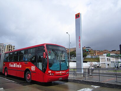
The intermediate station Calle 40 Sur is part of the TransMilenio mass-transit system of Bogotá, Colombia, opened in the year 2000.Wiki
Streets near Calle 48 Sur, Tunjuelito
Get around Tunjuelito by public transit!
Traveling around Tunjuelito has never been so easy. See step by step directions as you travel to any attraction, street or major public transit station. View bus and train schedules, arrival times, service alerts and detailed routes on a map, so you know exactly how to get to anywhere in Tunjuelito.
When traveling to any destination around Tunjuelito use Moovit's Live Directions with Get Off Notifications to know exactly where and how far to walk, how long to wait for your line, and how many stops are left. Moovit will alert you when it's time to get off — no need to constantly re-check whether yours is the next stop.
Wondering how to use public transit in Tunjuelito or how to pay for public transit in Tunjuelito? Moovit public transit app can help you navigate your way with public transit easily, and at minimum cost. It includes public transit fees, ticket prices, and costs. Looking for a map of Tunjuelito public transit lines? Moovit public transit app shows all public transit maps in Tunjuelito with all Bus, Cable Car and Funicular routes and stops on an interactive map.
Bogota has 3 transit type(s), including: Bus, Cable Car and Funicular, operated by several transit agencies, including Buses Troncales, TransMiZonal, Cerro de Monserrate, Aeropuerto El Dorado, TransMiCable, Flota Chia Ltda., Auto Servicio Chía Ltda. and Cootranscajicá Ltda.