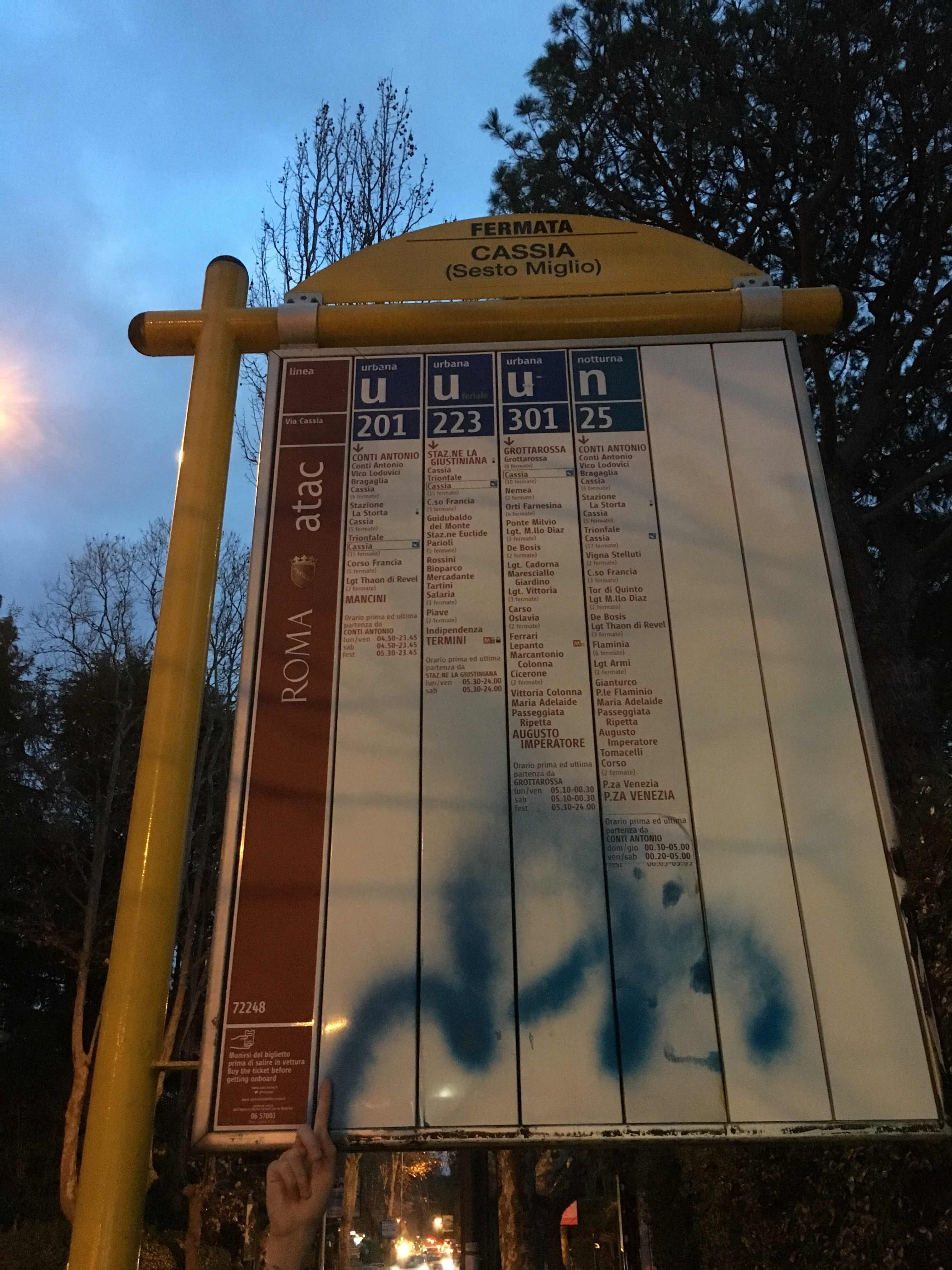
Cassia/Sixth Mile stop - Thursday schedule
| Line | Direction | Time |
|---|---|---|
| N201 | Piazza Venezia | 3:21 AM |
| N201 | Piazza Venezia | 3:21 AM |
| N201 | Piazza Venezia | 3:49 AM |
| N201 | Piazza Venezia | 3:49 AM |
| N201 | Piazza Venezia | 4:19 AM |
| N201 | Piazza Venezia | 4:19 AM |
| N201 | Piazza Venezia | 4:50 AM |
| N201 | Piazza Venezia | 4:50 AM |
| 301 | Giulio Cesare/Lepanto (Metro A) | 5:17 AM |
| 201 | Mancini | 5:18 AM |
| N201 | Piazza Venezia | 5:22 AM |
| N201 | Piazza Venezia | 5:22 AM |
| 201 | Mancini | 5:30 AM |
| COTRAL | Rome | Cornelia Terminal | 5:32 AM |
| 301 | Giulio Cesare/Lepanto (Metro A) | 5:34 AM |
| 223 | Termini (Metro A-Metro B-Railway) | 5:41 AM |
| 201 | Mancini | 5:43 AM |
| COTRAL | Rome | Cornelia Terminal | 5:47 AM |
| 301 | Giulio Cesare/Lepanto (Metro A) | 5:51 AM |
| 201 | Mancini | 5:56 AM |
| 223 | Termini (Metro A-Metro B-Railway) | 6:03 AM |
| COTRAL | Rome | Cornelia Terminal | 6:04 AM |
| 301 | Giulio Cesare/Lepanto (Metro A) | 6:06 AM |
| 201 | Mancini | 6:09 AM |
| 223 | Termini (Metro A-Metro B-Railway) | 6:15 AM |
Directions to Cassia/Sixth Mile stop (Roma) with public transit
The following transit lines have routes that pass near Cassia/Sixth Mile
 Bus: 301, 201, N201, 223, COTRAL.
- Train: FL3.
How to get to Cassia/Sixth Mile stop by bus?
Click on the bus route to see step by step directions with maps, line arrival times and updated time schedules.
How to get to Cassia/Sixth Mile stop by train?
Click on the train route to see step by step directions with maps, line arrival times and updated time schedules.
Bus stops near Cassia/Sixth Mile stop in Roma
- Cassia/Tomb of Nero, 5 min walk,
- Grottarossa/Casale Ghella, 8 min walk,
Train stations near Cassia/Sixth Mile station in Roma
- Vigna Clara, 16 min walk,
Bus lines to Cassia/Sixth Mile stop in Roma
- 201, Mancini,
- N201, Piazza Venezia,
- 223, La Giustiniana Station (FL3),
- 301, Giulio Cesare/Lepanto (Metro A),
- COTRAL, Blera to Piazza Giovanni XXIII,
- COTRAL, Manziana - Roma Cornelia,
- COTRAL, Blera - Roma Cornelia,
- COTRAL, Manziana - Roma Saxa Rubra,
- COTRAL, Viterbo - Roma Cornelia,
- 226, Tomba di Nerone - Piazza Mancini,
- 021, Grottarossa/Istituto Asisium,
What are the closest stations to Cassia/Sixth Mile?
The closest stations to Cassia/Sixth Mile are:
- Cassia/Tomb of Nero stop is 385 meters away, 5 min walk.
- Grottarossa/Casale Ghella stop is 599 meters away, 8 min walk.
- Vigna Clara station is 1234 meters away, 16 min walk.
Which bus line stops near Cassia/Sixth Mile?
301 (Grottarossa/Istituto Asisium)
Which train line stops near Cassia/Sixth Mile?
FL3 (Viterbo)
What’s the nearest train station to Cassia/Sixth Mile in Roma?
The nearest train station to Cassia/Sixth Mile in Roma is Vigna Clara. It’s a 16 min walk away.
What’s the nearest bus station to Cassia/Sixth Mile in Roma?
The nearest bus station to Cassia/Sixth Mile in Roma is Cassia/Tomb of Nero. It’s a 5 min walk away.
What time is the first train to Cassia/Sixth Mile in Roma?
The FL3 is the first train that goes to Cassia/Sixth Mile in Roma. It stops nearby at 5:56 AM.
What time is the last train to Cassia/Sixth Mile in Roma?
The FL3 is the last train that goes to Cassia/Sixth Mile in Roma. It stops nearby at 11:01 PM.
What time is the first bus to Cassia/Sixth Mile in Roma?
The N201 is the first bus that goes to Cassia/Sixth Mile in Roma. It stops nearby at 3:05 AM.
What time is the last bus to Cassia/Sixth Mile in Roma?
The N201 is the last bus that goes to Cassia/Sixth Mile in Roma. It stops nearby at 3:29 AM.
Cassia/Sixth Mile station
 Taken by Anonymous
See Cassia/Sixth Mile stop, Roma, on the map
Public transit to Cassia/Sixth Mile stop (ID: 72248) in Roma
Looking for directions to Cassia/Sixth Mile in Roma, Italy?
Download the Moovit App to find the current schedule and step-by-step directions for Bus, Train or Metro routes that pass through Cassia/Sixth Mile.
Looking for the nearest stops closest to Cassia/Sixth Mile ? Check out this list of closest stops to your destination: Cassia/Tomb of Nero; Grottarossa/Casale Ghella; Vigna Clara.
Bus: 301, 201, N201, 223, COTRAL, COTRAL, COTRAL, COTRAL, COTRAL, 226, 021.Train: FL3.
We make riding on public transit to Cassia/Sixth Mile easy, which is why over 1.7 billion users, including users in Roma trust Moovit as the best app for public transit.
Use the app to navigate to popular places including to the airport, hospital, stadium, grocery store, mall, coffee shop, school, college, and university.
Cassia/Sixth Mile stop’s code is 72248
The first line to this stop is N201, at 3:21 AM, and the last line is N201 at 2:53 AM.
This stop serves Cotral and ATAC’s lines
Popular routes from Cassia/Sixth Mile stop, Roma
- Cassia/Tomb of Nero,
- Grottarossa/Casale Ghella
Bus stops near Cassia/Sixth Mile stop
- Vigna Clara
Train station near Cassia/Sixth Mile station
- Marmorata/Galvani,
- Frosinone - Via Casilina Via Saragat,
- Rome | Sempione Square,
- Rocca Priora | Colle Di Fuori,
- Ottavia,
- Bardanzellu,
- Alberone,
- Saxa Rubra Station,
- S. Maria Maggiore,
- Roma Ostiense,
- Via Nettunense, 21,
- Bolognetta,
- Vatican Avenue/Vatican Museums,
- Cinecittà (Metro A),
- Nepi | Colle Farnese,
- Bufalotta/Monte Gennaro,
- Porta Metronia,
- Eur Fermi,
- Cicerone/Cavour,
- Ostiense Circle/Caffaro
Popular public transit stations in Roma
Get around Roma by public transit!
Traveling around Roma has never been so easy. See step by step directions as you travel to any attraction, street or major public transit station. View bus and train schedules, arrival times, service alerts and detailed routes on a map, so you know exactly how to get to anywhere in Roma.
When traveling to any destination around Roma use Moovit's Live Directions with Get Off Notifications to know exactly where and how far to walk, how long to wait for your line, and how many stops are left. Moovit will alert you when it's time to get off — no need to constantly re-check whether yours is the next stop.
Wondering how to use public transit in Roma or how to pay for public transit in Roma? Moovit public transit app can help you navigate your way with public transit easily, and at minimum cost. It includes public transit fees, ticket prices, and costs. Looking for a map of Roma public transit lines? Moovit public transit app shows all public transit maps in Roma with all Bus, Train, Metro, Light Rail, Ferry, Funicular and Gondola routes and stops on an interactive map.
Rome and Lazio has 7 transit type(s), including: Bus, Train, Metro, Light Rail, Ferry, Funicular and Gondola, operated by several transit agencies, including ATAC, Cotral, Trenitalia, Troiani Transportation Services, BIS, ATR Mobility, Tuscia, Shuttle, Seatour, Troiani Bus Lines, CSC Mobility, Terravision, ATRAL, Tambus and Sitbus