Directions to Chicago with public transportation
The following transit lines have routes that pass near Chicago
How to get to Chicago by bus?
Click on the bus route to see step by step directions with maps, line arrival times and updated time schedules.
How to get to Chicago by train?
Click on the train route to see step by step directions with maps, line arrival times and updated time schedules.
How to get to Chicago by Chicago 'L'?
Click on the Chicago 'L' route to see step by step directions with maps, line arrival times and updated time schedules.
Bus stops near Chicago
- Michigan & Illinois (South), 1 min walk,
- Illinois (Lower) & Michigan (East), 1 min walk,
- Michigan (Lower) & Illinois (North), 1 min walk,
- Michigan & Hubbard (Wrigley Bldg.) (South), 2 min walk,
- Michigan & Hubbard (Tribune Bldg.), 2 min walk,
- Michigan & Ontario, 4 min walk,
Chicago 'l' stations near Chicago
- Grand-Red, 6 min walk,
- State/Lake, 11 min walk,
Train stations near Chicago
- Millennium Station, 11 min walk,
Bus lines to Chicago
- 2, Midway Plaisance & Cottage Grove (East),
- 3, Fairbanks & Huron (South),
- 26, Chicago & Mies Van Der Rohe (East),
- 143, Michigan & Van Buren/Ida B. Wells (South),
- 146, State & Harrison/Ida B Wells Drive (South),
- 147, Paulina & Howard Terminal (North),
- 148, Marine Drive & Winona (North),
- 151, Belmont & Halsted Terminal (North),
- 157, Pulaski Pink Line Station (West),
- 29, State,
- 65, Grand,
- 120, Mcclurg & Huron (North),
- 121, Adams & Canal (West),
- 66, Chicago & Pulaski (West),
- 850, Plainfield Park-N-Ride,
- 855, Michigan Ave & Superior St,
- 851, Michigan Ave & Superior St,
- 125, Mies Van Der Rohe & Pearson (North),
What are the closest stations to Chicago?
The closest stations to Chicago are:
- Michigan & Illinois (South) is 22 yards away, 1 min walk.
- Illinois (Lower) & Michigan (East) is 23 yards away, 1 min walk.
- Michigan (Lower) & Illinois (North) is 34 yards away, 1 min walk.
- Michigan & Hubbard (Wrigley Bldg.) (South) is 135 yards away, 2 min walk.
- Michigan & Hubbard (Tribune Bldg.) is 150 yards away, 2 min walk.
- Michigan & Ontario is 278 yards away, 4 min walk.
- Grand-Red is 458 yards away, 6 min walk.
- Millennium Station is 853 yards away, 11 min walk.
- State/Lake is 855 yards away, 11 min walk.
Which bus lines stop near Chicago?
These bus lines stop near Chicago: 146, 147, 148, 2, 29, 3, 65.
Which train lines stop near Chicago?
These train lines stop near Chicago: MD-W, ME, UP-N, UP-NW.
Which Chicago 'L' lines stop near Chicago?
These Chicago 'L' lines stop near Chicago: GREEN LINE, RED LINE.
What’s the nearest Chicago 'L' station to Chicago?
The nearest Chicago 'L' station to Chicago is Grand-Red. It’s a 6 min walk away.
What’s the nearest train station to Chicago?
The nearest train station to Chicago is Millennium Station. It’s a 11 min walk away.
What’s the nearest bus stop to Chicago?
The nearest bus stops to Chicago are Michigan & Illinois (South), Illinois (Lower) & Michigan (East) and Michigan (Lower) & Illinois (North). The closest one is a 1 min walk away.
How much is the Chicago 'L' fare to Chicago?
The Chicago 'L' fare to Chicago costs about $2.50.
How much is the bus fare to Chicago?
The bus fare to Chicago costs about $2.25.
See Chicago on the map
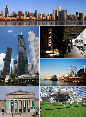
Montage of photos available on Wiki Commons
- File:2010-02-19 16500x2000 chicago skyline panorama.jpg panorama of Downtown Chicago by Jcrocker
- File:Chicago Sears Tower.jpg The Willis Tower by Dschwen
- File:20070719 Chicago Theatre.JPG the Chicago Theater by TonyTheTiger
- File:CTA waiting on the platform.jpg by Dschwen
- File:Navy Pier.jpg Chicago's Navy Pier by Cybjorg
- File:FieldMuseum.jpg The Field Museum by Ancheta Wis
- File:Gehry Pritzker.JPG Millenium Park by Mobius
Public Transportation to Chicago
Wondering how to get to Chicago, United States? Moovit helps you find the best way to get to Chicago with step-by-step directions from the nearest public transit station.
Moovit provides free maps and live directions to help you navigate through your city. View schedules, routes, timetables, and find out how long does it take to get to Chicago in real time.
Looking for the nearest stop or station to Chicago? Check out this list of stops closest to your destination: Michigan & Illinois (South); Illinois (Lower) & Michigan (East); Michigan (Lower) & Illinois (North); Michigan & Hubbard (Wrigley Bldg.) (South); Michigan & Hubbard (Tribune Bldg.); Michigan & Ontario; Grand-Red; Millennium Station; State/Lake.
Bus: 146, 147, 148, 2, 29, 3, 65, 26, 143, 120, 121.Train: MD-W, ME, UP-N, UP-NW, SSL.Chicago 'L': GREEN LINE, RED LINE, BROWN LINE, ORANGE LINE, PINK LINE, PURPLE LINE.
Want to see if there’s another route that gets you there at an earlier time? Moovit helps you find alternative routes or times. Get directions from and directions to Chicago easily from the Moovit App or Website.
We make riding to Chicago easy, which is why over 1.5 million users, including users in Chicago, trust Moovit as the best app for public transit. You don’t need to download an individual bus app or train app, Moovit is your all-in-one transit app that helps you find the best bus time or train time available.
For information on prices of bus, Chicago 'L' and train, costs and ride fares to Chicago, please check the Moovit app.
Use the app to navigate to popular places including to the airport, hospital, stadium, grocery store, mall, coffee shop, school, college, and university.
Chicago Address: 500 N Michigan Ave street in Chicago
Montage of photos available on Wiki Commons
- File:2010-02-19 16500x2000 chicago skyline panorama.jpg panorama of Downtown Chicago by Jcrocker
- File:Chicago Sears Tower.jpg The Willis Tower by Dschwen
- File:20070719 Chicago Theatre.JPG the Chicago Theater by TonyTheTiger
- File:CTA waiting on the platform.jpg by Dschwen
- File:Navy Pier.jpg Chicago's Navy Pier by Cybjorg
- File:FieldMuseum.jpg The Field Museum by Ancheta Wis
- File:Gehry Pritzker.JPG Millenium Park by Mobius
Attractions near Chicago
Purple Pig,Rentbacker,Pure Tax Resolution,Forerunner Computer Recycling Chicago,Giorgi & Bonomo,Webgreeter,Dint Corporate Housing,Solutions,Progent,Patti Kremer - Prospect Equities,Legacy Connections,Common Heart,Chicago Flooring Innovations,Vans,10com Web Development,M & M Stores,Murphy & Pressentin,Topel Forman,Metropole News Group,Wilmot Mountain ChicagoHow to get to popular attractions in Chicago with public transit
Rivers Casino, Des Plaines,Humboldt Park, Chicago,The Ritz-Carlton Chicago, Chicago,W Huron St, Chicago,Mannheim Rd (grand ave & mannheim road), Franklin Park,Chicago Metro, Chicago,lake michigan,Crestwood, IL, Crestwood,Ohare Airport Guard Post 1, Des Plaines,Oakbrook Center, Oak Brook,NCH Northwest Community Hospital, Arlington Heights,North Avenue Beach, Chicago,Magnificent Mile, Chicago,Russo Surgical Pavilion - Loyola,O'Hare International Airport - Bus Shuttle Center Door 4, Chicago,Douglas Park, Chicago,La Villita Park, Chicago,Hard Rock Casino Northern Indiana, Gary,Ameristar Casino Hotel East Chicago, East Chicago,First Midwest Bank Amphitheatre (Hollywood Casino Amphitheater), Tinley ParkGet around Chicago by public transit!
Traveling around Chicago has never been so easy. See step by step directions as you travel to any attraction, street or major public transit station. View bus and train schedules, arrival times, service alerts and detailed routes on a map, so you know exactly how to get to anywhere in Chicago.
When traveling to any destination around Chicago use Moovit's Live Directions with Get Off Notifications to know exactly where and how far to walk, how long to wait for your line, and how many stops are left. Moovit will alert you when it's time to get off — no need to constantly re-check whether yours is the next stop.
Wondering how to use public transit in Chicago or how to pay for public transit in Chicago? Moovit public transit app can help you navigate your way with public transit easily, and at minimum cost. It includes public transit fees, ticket prices, and costs. Looking for a map of Chicago public transit lines? Moovit public transit app shows all public transit maps in Chicago with all Bus, Train and Chicago 'L' routes and stops on an interactive map.
Chicago has 3 transit type(s), including: Bus, Train and Chicago 'L', operated by several transit agencies, including CTA 'L', Metra, Northern Indiana Commuter Transportation District, CTA, PACE, Gary Public Transit, Amtrak, River Valley Metro, Valpo Transit, DeKalb Public Transit, FlixBus-us, Greyhound-us, Van Galder (Coach USA), Wisconsin Coach Lines