See Chiesa di San Sisto Viterbo on the map
Directions to Chiesa di San Sisto Viterbo with public transportation
The following transit lines have routes that pass near Chiesa di San Sisto Viterbo
 Bus:
Bus: - Train:
How to get to Chiesa di San Sisto Viterbo by bus?
Click on the bus route to see step by step directions with maps, line arrival times and updated time schedules.
How to get to Chiesa di San Sisto Viterbo by train?
Click on the train route to see step by step directions with maps, line arrival times and updated time schedules.
Bus stations near Chiesa di San Sisto Viterbo
- Piazza Del Plebiscito,4 min walk,
- Sacrario,7 min walk,
- Sacrario Terminal,7 min walk,
- Via Vico Squarano,9 min walk,
- Viterbo | Porta Romana FS,10 min walk,
- Viterbo | Via Capocci Istituto Savi,10 min walk,
Train stations near Chiesa di San Sisto Viterbo
- Viterbo,22 min walk,
- Viterbo Porta Fiorentina,24 min walk,
Bus lines to Chiesa di San Sisto Viterbo
- 1C,Salamaro-Sacrario,
- A,Circolare A,
- B,Circolare B,
- 5,Grotte Santo Stefano,
- 6,Bagnaia,
- 8,Tobia,
- 11,Belcolle / San Martino,
- AG,Sacrario,
- 2,Terme-Sacrario,
- 9,Santa Barbara,
- 12,Roccalvecce,
- 14,Poggino,
- 2F,Terme-Riello,
- BUS,Montefiascone - Viterbo,
- 11F,Belcolle / San Martino,
- COTRAL,Viterbo - Vetralla - Capranica - Sutri - Bassano R.,
- COTRAL,Acquapendente | Via Cassia Via Porta S. Angelo - Viterbo | Riello,
- COTRAL,Viterbo | Riello - Roma | Capolinea Cornelia,
- COTRAL,Viterbo | Riello - Vejano | Piazza Diaz,
- COTRAL,Valentano | Via Marconi Via Roma - Viterbo | Riello,
What are the closest stations to Chiesa di San Sisto Viterbo?
The closest stations to Chiesa di San Sisto Viterbo are:
- Piazza Del Plebiscito is 247 meters away, 4 min walk.
- Sacrario is 459 meters away, 7 min walk.
- Sacrario Terminal is 488 meters away, 7 min walk.
- Via Vico Squarano is 638 meters away, 9 min walk.
- Viterbo | Porta Romana FS is 695 meters away, 10 min walk.
- Viterbo | Via Capocci Istituto Savi is 743 meters away, 10 min walk.
- Viterbo is 1654 meters away, 22 min walk.
- Viterbo Porta Fiorentina is 1881 meters away, 24 min walk.
Which bus lines stop near Chiesa di San Sisto Viterbo?
These bus lines stop near Chiesa di San Sisto Viterbo: COTRAL, EXP.
Which train lines stop near Chiesa di San Sisto Viterbo?
These train lines stop near Chiesa di San Sisto Viterbo: FC3, R.
What’s the nearest train station to Chiesa di San Sisto Viterbo?
The nearest train station to Chiesa di San Sisto Viterbo is Viterbo. It’s a 22 min walk away.
What’s the nearest bus stop to Chiesa di San Sisto Viterbo?
The nearest bus stop to Chiesa di San Sisto Viterbo is Piazza Del Plebiscito. It’s a 4 min walk away.
What time is the first train to Chiesa di San Sisto Viterbo?
The FC3 is the first train that goes to Chiesa di San Sisto Viterbo. It stops nearby at 6:50 AM.
What time is the last train to Chiesa di San Sisto Viterbo?
The R is the last train that goes to Chiesa di San Sisto Viterbo. It stops nearby at 9:35 PM.
What time is the first bus to Chiesa di San Sisto Viterbo?
The COTRAL is the first bus that goes to Chiesa di San Sisto Viterbo. It stops nearby at 5:32 AM.
What time is the last bus to Chiesa di San Sisto Viterbo?
The COTRAL is the last bus that goes to Chiesa di San Sisto Viterbo. It stops nearby at 10:52 PM.
See Chiesa di San Sisto Viterbo on the map
Public Transportation to Chiesa di San Sisto Viterbo
Wondering how to get to Chiesa di San Sisto Viterbo, Italy? Moovit helps you find the best way to get to Chiesa di San Sisto Viterbo with step-by-step directions from the nearest public transit station.
Moovit provides free maps and live directions to help you navigate through your city. View schedules, routes, timetables, and find out how long does it take to get to Chiesa di San Sisto Viterbo in real time.
Looking for the nearest stop or station to Chiesa di San Sisto Viterbo? Check out this list of stops closest to your destination: Piazza Del Plebiscito; Sacrario; Sacrario Terminal; Via Vico Squarano; Viterbo | Porta Romana FS; Viterbo | Via Capocci Istituto Savi; Viterbo; Viterbo Porta Fiorentina.
Bus:Train:
Want to see if there’s another route that gets you there at an earlier time? Moovit helps you find alternative routes or times. Get directions from and directions to Chiesa di San Sisto Viterbo easily from the Moovit App or Website.
We make riding to Chiesa di San Sisto Viterbo easy, which is why over 1.5 million users, including users in Viterbo, trust Moovit as the best app for public transit. You don’t need to download an individual bus app or train app, Moovit is your all-in-one transit app that helps you find the best bus time or train time available.
For information on prices of bus and train, costs and ride fares to Chiesa di San Sisto Viterbo, please check the Moovit app.
Use the app to navigate to popular places including to the airport, hospital, stadium, grocery store, mall, coffee shop, school, college, and university.
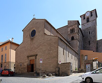
Chiesa di San Sisto Viterbo Address: Via dei Pellegrini, 23 01100 Viterbo street in Viterbo
San Sisto is a Romanesque-style Roman Catholic church in the town of Viterbo in the Region of Lazio. The church was once known as San Sisto fuori la Porta Romana.Wiki
Attractions near Chiesa di San Sisto Viterbo
Caffeina Christmas Village,Perla Calzature,Negozio Sartoria,Torre del Borgognone (Ex Torre di San Silvestro),Chocolat di Tisci Carmine e C.,Nitro Giuseppe,De Larrea Antonio Eduardo,Duomo Café,Il Bar delle Meraviglie,Studio Tributario Moretti e Partners,Al22 di Piazza del Gesù,La Vecchia Viterbo e I Suoi Sapori - Prodotti Tipici,Condominio Car,F. Caldarelli,Viterbo Underground,Pizzeria del Ghetto 2.0,Via Fattungheri,La Tana degli Orchi,Edil Service 2000,Galleria del Tappeto S. Pellegrino di Sanjary SaidHow to get to popular attractions in Viterbo with public transit
The American University Of Rome, Roma,Prati Fiscali, Roma,Ponte Milvio, Roma,Roma Est, Roma,Albero Di Natale Stazione Termini, Roma,Villa Mirafiori, Roma,Basilica Di San Paolo Fuori Le Mura, Roma,Crowne Plaza Rome - St. Peter's, Roma,Fiano Romano, Fiano Romano,Colosseo, Roma,Roma Termini, Roma,Palalottomatica, Roma,Basilica Di Santa Maria In Trastevere, Roma,Staz.ne Tiburtina, Roma,Spinaceto, Roma,Università Cattolica Del Sacro Cuore, Roma,Metro Garbatella, Roma,Università Degli Studi Di Roma Tor Vergata - Facoltà Di Ingegneria, Roma,Piazza Pio Undicesimo, Roma,Piazza Di Spagna, RomaGet around Viterbo by public transit!
Traveling around Viterbo has never been so easy. See step by step directions as you travel to any attraction, street or major public transit station. View bus and train schedules, arrival times, service alerts and detailed routes on a map, so you know exactly how to get to anywhere in Viterbo.
When traveling to any destination around Viterbo use Moovit's Live Directions with Get Off Notifications to know exactly where and how far to walk, how long to wait for your line, and how many stops are left. Moovit will alert you when it's time to get off — no need to constantly re-check whether yours is the next stop.
Wondering how to use public transit in Viterbo or how to pay for public transit in Viterbo? Moovit public transit app can help you navigate your way with public transit easily, and at minimum cost. It includes public transit fees, ticket prices, and costs. Looking for a map of Viterbo public transit lines? Moovit public transit app shows all public transit maps in Viterbo with all bus or train routes and stops on an interactive map.
Viterbo has 2 transit type(s), including: bus or train, operated by several transit agencies, including ATAC, ATAC, Cotral, Trenitalia, ATAC, ATAC, Roma TPL, Navette, Autoservizi Troiani, Seatour, Autolinee Troiani, CSC Mobilità, BIS, Terravision and ATRAL