See Civic Center Marta Station, Atlanta, on the map
Directions to Civic Center Marta Station (Atlanta) with public transportation
The following transit lines have routes that pass near Civic Center Marta Station
 Bus:
Bus: - Subway:
How to get to Civic Center Marta Station by bus?
Click on the bus route to see step by step directions with maps, line arrival times and updated time schedules.
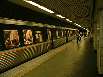
How to get to Civic Center Marta Station by subway?
Click on the subway route to see step by step directions with maps, line arrival times and updated time schedules.
Bus stations near Civic Center Marta Station in Atlanta
- Atlanta Downtown (Civic Center),1 min walk,
- Civic Center Station (West Peachtreet Street),1 min walk,
- Civic Center Marta Station,1 min walk,
- Ivan Allen at Alexander St,4 min walk,
- Peachtree St @ Pine St NE,4 min walk,
- Peachtree Center Ave @ Peachtree St,6 min walk,
Light Rail stations near Civic Center Marta Station in Atlanta
- Peachtree Center Station,6 min walk,
Subway stations near Civic Center Marta Station in Atlanta
- North Avenue Station,57 min walk,
Bus lines to Civic Center Marta Station in Atlanta
- FLIXBUS 2415,Orlando (The Florida Mall),
- FLIXBUS N2415,Atlanta Downtown (Civic Center),
- FLIXBUS N2470,New York Midtown (31st St & 8th Ave),
- 100,Busbee Park & Ride,
- 101,Marietta Transfer Center,
- 411,411 Midtown,
- 412,412 Midtown,
- 414,414 Hamilton Mill / Mall Of Georgia / Sugarloaf Mi,
- 423,423 Panola / West Conyers / East Conyers,
- 430,430 Downtown,
- 431,431 Stockbridge / Brandsmart,
- 432,432 Downtown,
- 440,440 Hampton / Jonesboro,
- 441,441 Downtown / Midtown,
- 442,442 Downtown,
- 453,453 Downtown / Midtown,
- 463,West Douglas / Douglas Mmtc,
- 476,476 Downtown / Midtown,
- 483,483 Woodstock / Town Center,
- 484,484 Midtown,
What are the closest stations to Civic Center Marta Station?
The closest stations to Civic Center Marta Station are:
- Atlanta Downtown (Civic Center) is 16 yards away, 1 min walk.
- Civic Center Station (West Peachtreet Street) is 26 yards away, 1 min walk.
- Civic Center Marta Station is 27 yards away, 1 min walk.
- Ivan Allen at Alexander St is 255 yards away, 4 min walk.
- Peachtree St @ Pine St NE is 327 yards away, 4 min walk.
- Peachtree Center Ave @ Peachtree St is 445 yards away, 6 min walk.
- Peachtree Center Station is 455 yards away, 6 min walk.
- North Avenue Station is 4785 yards away, 57 min walk.
Which bus lines stop near Civic Center Marta Station?
These bus lines stop near Civic Center Marta Station: 101, 40, 440, 50.
Which subway lines stop near Civic Center Marta Station?
These subway lines stop near Civic Center Marta Station: GOLD, RED.
What’s the nearest light rail station to Civic Center Marta Station in Atlanta?
The nearest light rail station to Civic Center Marta Station in Atlanta is Peachtree Center Station. It’s a 6 min walk away.
What’s the nearest bus stop to Civic Center Marta Station in Atlanta?
The nearest bus stops to Civic Center Marta Station in Atlanta are Atlanta Downtown (Civic Center), Civic Center Station (West Peachtreet Street) and Civic Center Marta Station. The closest one is a 1 min walk away.
What time is the first light rail to Civic Center Marta Station in Atlanta?
The ATLSC is the first light rail that goes to Civic Center Marta Station in Atlanta. It stops nearby at 8:25 AM.
What time is the last light rail to Civic Center Marta Station in Atlanta?
The ATLSC is the last light rail that goes to Civic Center Marta Station in Atlanta. It stops nearby at 11:03 PM.
What time is the first subway to Civic Center Marta Station in Atlanta?
The RED is the first subway that goes to Civic Center Marta Station in Atlanta. It stops nearby at 5:00 AM.
What time is the last subway to Civic Center Marta Station in Atlanta?
The GOLD is the last subway that goes to Civic Center Marta Station in Atlanta. It stops nearby at 1:41 AM.
What time is the first bus to Civic Center Marta Station in Atlanta?
The 40 is the first bus that goes to Civic Center Marta Station in Atlanta. It stops nearby at 5:22 AM.
What time is the last bus to Civic Center Marta Station in Atlanta?
The FLIXBUS N2470 is the last bus that goes to Civic Center Marta Station in Atlanta. It stops nearby at 9:15 AM.
How much is the subway fare to Civic Center Marta Station?
The subway fare to Civic Center Marta Station costs about $2.50.
How much is the bus fare to Civic Center Marta Station?
The bus fare to Civic Center Marta Station costs about $2.50.
See Civic Center Marta Station, Atlanta, on the map
Public Transit to Civic Center Marta Station in Atlanta
Wondering how to get to Civic Center Marta Station in Atlanta, United States? Moovit helps you find the best way to get to Civic Center Marta Station with step-by-step directions from the nearest public transit station.
Moovit provides free maps and live directions to help you navigate through your city. View schedules, routes, timetables, and find out how long does it take to get to Civic Center Marta Station in real time.
Looking for the nearest stop or station to Civic Center Marta Station? Check out this list of stops closest to your destination: Atlanta Downtown (Civic Center); Civic Center Station (West Peachtreet Street); Civic Center Marta Station; Ivan Allen at Alexander St; Peachtree St @ Pine St NE; Peachtree Center Ave @ Peachtree St; Peachtree Center Station; North Avenue Station.
Bus:Subway:
Want to see if there’s another route that gets you there at an earlier time? Moovit helps you find alternative routes or times. Get directions from and directions to Civic Center Marta Station easily from the Moovit App or Website.
We make riding to Civic Center Marta Station easy, which is why over 1.5 million users, including users in Atlanta, trust Moovit as the best app for public transit. You don’t need to download an individual bus app or train app, Moovit is your all-in-one transit app that helps you find the best bus time or train time available.
For information on prices of bus and subway, costs and ride fares to Civic Center Marta Station, please check the Moovit app.
Use the app to navigate to popular places including to the airport, hospital, stadium, grocery store, mall, coffee shop, school, college, and university.
Civic Center Marta Station Address: W Peachtree St NW street in Atlanta
Attractions near Civic Center Marta Station
Civic Center,435 West Peachtree Street Northwest,MegaBus / Civic Center Station,Marta/Megabus,MARTA - Civic Center Station,Atlanta GA W Peachtree St Civic Center MARTA Station,SP+ Parking,24k Rentals,Atlanta Executive Limousine,Tailored Beaute Solutions,Wamogi Management Group,David Brand,Fetch Pets,National Black Mba Association,Deborah Landy,Express Refunds KNM,Ju-Tox Juice Bar & Wellness Center,435 W Peachtree St NW,MARTA-Civic Center Station (W Peachtree St @ Civic Center Marta Station),Twelve Downtown, Autograph CollectionHow to get to popular attractions in Atlanta with public transit
Rockbridge Road & Lawrenceville Highway, Lilburn,Burlington Coat Factory, Marietta,Thornton road park and ride, Lithia Springs,Golden Corral, Gwinnett,Central Gwinnett High School, Lawrenceville,Delta GOE Shuttle Bus Stop, Atlanta,Marta Windward Park & Ride, Alpharetta,John Alexander Memorial Park, Mcdonough,I 20 Exit 63/ Gresham Rd, Dekalb,Mall at Stonecrest, Dekalb,Applebee's Neighborhood Grill & Bar, Tucker,Piedmont Eye Surgery Center, Atlanta,Oakmont Campus (Chick-fil-A), College Park,CDC @ University Office Park, Dekalb,I-285 Exit 18 Paces Ferry Rd, Vinings,Main Street- Tucker, GA, Tucker,MARTA Bus 110 "The Peach", Atlanta,NASCO, Sandy Springs,10 10th Street, Atlanta, GA, Atlanta,Exit 249D - North Ave./GA Tech, AtlantaGet around Atlanta by public transit!
Traveling around Atlanta has never been so easy. See step by step directions as you travel to any attraction, street or major public transit station. View bus and train schedules, arrival times, service alerts and detailed routes on a map, so you know exactly how to get to anywhere in Atlanta.
When traveling to any destination around Atlanta use Moovit's Live Directions with Get Off Notifications to know exactly where and how far to walk, how long to wait for your line, and how many stops are left. Moovit will alert you when it's time to get off — no need to constantly re-check whether yours is the next stop.
Wondering how to use public transit in Atlanta or how to pay for public transit in Atlanta? Moovit public transit app can help you navigate your way with public transit easily, and at minimum cost. It includes public transit fees, ticket prices, and costs. Looking for a map of Atlanta public transit lines? Moovit public transit app shows all public transit maps in Atlanta with all bus or subway routes and stops on an interactive map.
Atlanta has 2 transit type(s), including: bus or subway, operated by several transit agencies, including MARTA, MARTA, Metropolitan Atlanta Rapid Transit Authority, Xpress, Atlantic Station Shuttle, CobbLinc, Ride Gwinnett, Connect Douglas, Amtrak, Stinger Bus and Tech Trolley, Emory University Transportation , Panther Express, Atlanta University Center Shuttle , Rome Transit Department and FlixBus-us