See Dean Road, Brookline, on the map
Directions to Dean Road (Brookline) with public transportation
The following transit lines have routes that pass near Dean Road
 Bus:
Bus: - Train:
- Subway:
How to get to Dean Road by bus?
Click on the bus route to see step by step directions with maps, line arrival times and updated time schedules.
How to get to Dean Road by train?
Click on the train route to see step by step directions with maps, line arrival times and updated time schedules.
How to get to Dean Road by subway?
Click on the subway route to see step by step directions with maps, line arrival times and updated time schedules.
Bus stations near Dean Road in Brookline
- Washington St @ Beacon St,8 min walk,
Subway stations near Dean Road in Brookline
- Washington Street,11 min walk,
Bus lines to Dean Road in Brookline
- 65,Kenmore,
What are the closest stations to Dean Road?
The closest stations to Dean Road are:
- Washington St @ Beacon St is 621 yards away, 8 min walk.
- Washington Street is 909 yards away, 11 min walk.
Which bus lines stop near Dean Road?
These bus lines stop near Dean Road: 65, 86, GREEN LINE C SHUTTLE.
Which train line stops near Dean Road?
FRAMINGHAM/WORCESTER
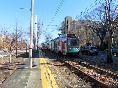
Which subway line stops near Dean Road?
GREEN LINE D
What’s the nearest subway station to Dean Road in Brookline?
The nearest subway station to Dean Road in Brookline is Washington Street. It’s a 11 min walk away.
What’s the nearest bus stop to Dean Road in Brookline?
The nearest bus stop to Dean Road in Brookline is Washington St @ Beacon St. It’s a 8 min walk away.
See Dean Road, Brookline, on the map
Public Transit to Dean Road in Brookline
Wondering how to get to Dean Road in Brookline, United States? Moovit helps you find the best way to get to Dean Road with step-by-step directions from the nearest public transit station.
Moovit provides free maps and live directions to help you navigate through your city. View schedules, routes, timetables, and find out how long does it take to get to Dean Road in real time.
Looking for the nearest stop or station to Dean Road? Check out this list of stops closest to your destination: Washington St @ Beacon St; Washington Street.
Bus:Train:Subway:
Want to see if there’s another route that gets you there at an earlier time? Moovit helps you find alternative routes or times. Get directions from and directions to Dean Road easily from the Moovit App or Website.
We make riding to Dean Road easy, which is why over 1.5 million users, including users in Brookline, trust Moovit as the best app for public transit. You don’t need to download an individual bus app or train app, Moovit is your all-in-one transit app that helps you find the best bus time or train time available.
For information on prices of bus, subway and train, costs and ride fares to Dean Road, please check the Moovit app.
Use the app to navigate to popular places including to the airport, hospital, stadium, grocery store, mall, coffee shop, school, college, and university.
Dean Road Address: Beacon Street street in Brookline
Attractions near Dean Road
Beacon Street,Aids & STD Testing,Englewood Avenue MBTA - Green Line,MBTA-Beaconsfield,Beaconsfield,Dock,Star Market,187 Clinton Rd,MBTA Tappan Street Station,Barcelona Wine Bar,90 Kilsyth Road,369 Tappan St,We Buy Old Properties Sell A House,Runkle Elementary School K-8 50 Druce Elementary School,Longwood Dental Group,Brookline Development Corp,CBNM,5 Colliston Rd,Coolidge Corner Farmers Market,115 Dean RdHow to get to popular attractions in Brookline with public transit
Neptune Oyster, Boston,Dorchester, Boston,Lowell, MA, Lowell,Samuel Adams Brewery, Boston,Staples Corporate HQ, Framingham,Modern Pastry Shop, Boston,Worcester Polytechnic Institute (WPI), Worcester,Target,Cliff Walk,MBTA Commuter Rail South Attleboro, Attleboro,Inman Square, Cambridge,BonChon Chicken, Boston,The Capital Grille, Boston,Bell In Hand Tavern, Boston,Redbones Barbecue, Somerville,Brown University,Barrington, RI,Newton, MA, Newton,Bunker Hill Community College, Boston,The Phoenix Landing, CambridgeGet around Brookline by public transit!
Traveling around Brookline has never been so easy. See step by step directions as you travel to any attraction, street or major public transit station. View bus and train schedules, arrival times, service alerts and detailed routes on a map, so you know exactly how to get to anywhere in Brookline.
When traveling to any destination around Brookline use Moovit's Live Directions with Get Off Notifications to know exactly where and how far to walk, how long to wait for your line, and how many stops are left. Moovit will alert you when it's time to get off — no need to constantly re-check whether yours is the next stop.
Wondering how to use public transit in Brookline or how to pay for public transit in Brookline? Moovit public transit app can help you navigate your way with public transit easily, and at minimum cost. It includes public transit fees, ticket prices, and costs. Looking for a map of Brookline public transit lines? Moovit public transit app shows all public transit maps in Brookline with all bus, subway or train routes and stops on an interactive map.
Brookline has 3 transit type(s), including: bus, subway or train, operated by several transit agencies, including MBTA, MBTA, MBTA, Southeastern Regional Transit Authority, MetroWest Regional Transit Authority, Rhode Island Public Transit Authority, WRTA, Lowell Regional Transit Authority, Merrimack Valley Transit, Montachusett Regional Transit Authority, Cape Cod Regional Transit Authority, Brockton Area Transit Authority, Cape Cod Regional Transit Authority, Martha's Vineyard Transit Authority and the WAVE - Nantucket Regional Transit Authority