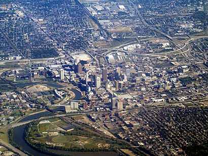
See Downtown Columbus, Ohio on the map
Directions to Downtown Columbus, Ohio with public transportation
The following transit lines have routes that pass near Downtown Columbus, Ohio
Bus:
How to get to Downtown Columbus, Ohio by Bus?
Click on the Bus route to see step by step directions with maps, line arrival times and updated time schedules.
Bus stations near Downtown Columbus, Ohio
- E Long St & Cleveland Ave,3 min walk,
- E Broad St & S 4th St,4 min walk,
- E Spring St & Neilston St,4 min walk,
- N 3rd St & E Gay St,5 min walk,
- N 4th St & E Gay St,5 min walk,
- E Naghten St & N 5th St,5 min walk,
- N 4th St & E Spring St,6 min walk,
Bus lines to Downtown Columbus, Ohio
- 7,E Mound St & S 4th St,
- 9,Easton Terminal Bay 8,
- 11,1755 Alum Creek Dr,
- 10,E Broad St & Mt Carmel East Hospital,
- 41,Crosswoods Park And Ride,
- 42,Sharon Woods Blvd & Skywae Dr,
- 43,Westerville Park And Ride,
- 44,Easton Terminal Bay 4,
- 45,New Albany Park & Ride,
- 46,Cota Transit Terminal Bay 8,
- ZOO,E State St & S High St,
- 3,W Spring St & N Front St,
- 6,Spring St Terminal Bay 2,
- 8,Great Southern Park And Ride,
- 51,Reynoldsburg Park & Ride,
- 52,Canal Winchester Park & Ride,
- 61,Grove City Park And Ride,
- 71,Heritage Club Dr & Main St,
- 72,5054 Parkcenter Ave,
- 73,Cota Transit Terminal Bay 9,
What are the closest stations to Downtown Columbus, Ohio?
The closest stations to Downtown Columbus, Ohio are:
- E Long St & Cleveland Ave is 184 yards away, 3 min walk.
- E Broad St & S 4th St is 259 yards away, 4 min walk.
- E Spring St & Neilston St is 294 yards away, 4 min walk.
- N 3rd St & E Gay St is 373 yards away, 5 min walk.
- N 4th St & E Gay St is 385 yards away, 5 min walk.
- E Naghten St & N 5th St is 386 yards away, 5 min walk.
- N 4th St & E Spring St is 493 yards away, 6 min walk.
Which Bus lines stop near Downtown Columbus, Ohio?
These Bus lines stop near Downtown Columbus, Ohio: 1, 10, 11, 4, 5, 7
What’s the nearest bus stop to Downtown Columbus, Ohio?
The nearest bus stop to Downtown Columbus, Ohio is E Long St & Cleveland Ave. It’s a 3 min walk away.
How much is the Bus fare to Downtown Columbus, Ohio?
The Bus fare to Downtown Columbus, Ohio costs about $2.00.
See Downtown Columbus, Ohio on the map

Public Transportation to Downtown Columbus, Ohio
Wondering how to get to Downtown Columbus, Ohio, United States? Moovit helps you find the best way to get to Downtown Columbus, Ohio with step-by-step directions from the nearest public transit station.
Moovit provides free maps and live directions to help you navigate through your city. View schedules, routes, timetables, and find out how long does it take to get to Downtown Columbus, Ohio in real time.
Looking for the nearest stop or station to Downtown Columbus, Ohio? Check out this list of stops closest to your destination: E Long St & Cleveland Ave; E Broad St & S 4th St; E Spring St & Neilston St; N 3rd St & E Gay St; N 4th St & E Gay St; E Naghten St & N 5th St; N 4th St & E Spring St.
Bus:
Want to see if there’s another route that gets you there at an earlier time? Moovit helps you find alternative routes or times. Get directions from and directions to Downtown Columbus, Ohio easily from the Moovit App or Website.
We make riding to Downtown Columbus, Ohio easy, which is why over 1.5 million users, including users in Columbus, trust Moovit as the best app for public transit. You don’t need to download an individual bus app or train app, Moovit is your all-in-one transit app that helps you find the best bus time or train time available.
For information on prices of Bus, costs and ride fares to Downtown Columbus, Ohio, please check the Moovit app.
Use the app to navigate to popular places including to the airport, hospital, stadium, grocery store, mall, coffee shop, school, college, and university.
Downtown Columbus, Ohio Address: Columbus, OH 43215 street in Columbus

Attractions near Downtown Columbus, Ohio
- E Lafayette St
- Holy Trinity Brewing Company
- Prime Saturdays
- District West
- Park Place Parking - Lot #1
- 4th & Long Lot
- Haignere Johnson & McVey
- Idegy Marketplace
- Elevator Brewery
- Jackie O's Pub & Brewery
- Jackie O's on Fourth
- Long and Neilston
- Energy Professionals of Ohio
- General Tire Lot
- General Tire Sales
- National Tire & Battery
- 138 E Lafayette St
- Nationwide Children's Hospital
- Icon Night Club
- Kephart Fisher
How to get to popular attractions in Columbus with public transit
- AC Hotels by Marriott Dublin, Dublin
- Lou's Cafe (Drinko Hall), Columbus
- Center Point Acupuncture Medicine, LLC, Columbus
- The Buckeye Corner, Columbus
- Carriage Place, Columbus
- gulf shores Alabama, Columbus
- Victoria Village, Columbus
- Grove City, Grove City
- Dublin City Schools, Dublin
- Penn Station, Columbus
- Capital Care Women's Center, Columbus
- Ace Handyman Services East Columbus, Gahanna
- CVS Pharmacy, Reynoldsburg
- Osu Medical Center Carepoint East, Columbus
- Skiptown - Columbus, Columbus
- New Albany Middle School Gymnasium, Columbus
- Redeemers On Courtright (ROC), Columbus
- Waremala Irrigation, Columbus
- Tipsy Tuesday, Columbus
- Devoted Mechanical, Columbus