Directions to Edmonds St, Edmonds, WA 98020 with public transportation
The following transit lines have routes that pass near Edmonds St, Edmonds, WA 98020
How to get to Edmonds St, Edmonds, WA 98020 by bus?
Click on the bus route to see step by step directions with maps, line arrival times and updated time schedules.
Bus stops near Edmonds St, Edmonds, WA 98020
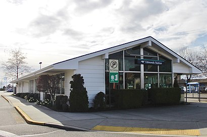
- Edmonds Station, 14 min walk,
- Hwy 99 & 216th St Sw, 53 min walk,
- Aurora Ave N & N 192nd St, 82 min walk,
Train stations near Edmonds St, Edmonds, WA 98020
- Edmonds Station, 16 min walk,
Bus lines to Edmonds St, Edmonds, WA 98020
- 102, Edmonds - Lynnwood TC,
- 130, Edmonds - Lynnwood,
- 166, Edmonds - Silver Firs,
- 909, Edmonds Station - Mountlake Terrace Station,
- 101, Mariner P&R,
- E LINE, Stadium Station Downtown Seattle,
What are the closest stations to Edmonds St, Edmonds, WA 98020?
The closest stations to Edmonds St, Edmonds, WA 98020 are:
- Edmonds Station is 1122 yards away, 14 min walk.
- Hwy 99 & 216th St Sw is 4361 yards away, 53 min walk.
- Aurora Ave N & N 192nd St is 6880 yards away, 82 min walk.
Which bus lines stop near Edmonds St, Edmonds, WA 98020?
These bus lines stop near Edmonds St, Edmonds, WA 98020: 116, 130.
What’s the nearest train station to Edmonds St, Edmonds, WA 98020?
The nearest train station to Edmonds St, Edmonds, WA 98020 is Edmonds Station. It’s a 16 min walk away.
What’s the nearest bus stop to Edmonds St, Edmonds, WA 98020?
The nearest bus stop to Edmonds St, Edmonds, WA 98020 is Edmonds Station. It’s a 14 min walk away.
See Edmonds St, Edmonds, WA 98020 on the map
Public Transportation to Edmonds St, Edmonds, WA 98020
Wondering how to get to Edmonds St, Edmonds, WA 98020, United States? Moovit helps you find the best way to get to Edmonds St, Edmonds, WA 98020 with step-by-step directions from the nearest public transit station.
Moovit provides free maps and live directions to help you navigate through your city. View schedules, routes, timetables, and find out how long does it take to get to Edmonds St, Edmonds, WA 98020 in real time.
Looking for the nearest stop or station to Edmonds St, Edmonds, WA 98020? Check out this list of stops closest to your destination: Edmonds Station; Hwy 99 & 216th St Sw; Aurora Ave N & N 192nd St.
Bus: 116, 130, 102, 166, 909, 101, E LINE.Train: AMTRAK CASCADES, EMPIRE BUILDER, N LINE.
Want to see if there’s another route that gets you there at an earlier time? Moovit helps you find alternative routes or times. Get directions from and directions to Edmonds St, Edmonds, WA 98020 easily from the Moovit App or Website.
We make riding to Edmonds St, Edmonds, WA 98020 easy, which is why over 1.5 million users, including users in Edmonds, trust Moovit as the best app for public transit. You don’t need to download an individual bus app or train app, Moovit is your all-in-one transit app that helps you find the best bus time or train time available.
For information on prices of bus, costs and ride fares to Edmonds St, Edmonds, WA 98020, please check the Moovit app.
Use the app to navigate to popular places including to the airport, hospital, stadium, grocery store, mall, coffee shop, school, college, and university.
Edmonds St, Edmonds, WA 98020 Address: Edmonds, WA 98020 street in Edmonds
Attractions near Edmonds St, Edmonds, WA 98020
7th Edmonds,700 Edmonds St,322 7th Ave N ,333 7th Ave N,224 7th Ave N,Classico Homes,7th Avenue North,7th Ave N / Bell St,7th Ave N,698 Bell St,700 Bell St,Simply Speech,715 Sprague St,Winifred Bainbridge,Civic Center Playfield,Brook Street Securities,Gill Plastering & Drywall,Jeff Curtis,700 Daley St,101 7th Ave NHow to get to popular attractions in Edmonds with public transit
Alaska Airlines Gold Coast Center, Seatac,City of Tacoma, Tacoma,Marysville, WA,Pike Place Market, Seattle,Sea Airport, Seatac,Walmart Supercenter, Lakewood,Shoreline Community College, Shoreline,City of Puyallup, Puyallup,Quil Ceda Creek Casino & Nightclub,The Home Depot,Camp Murray,Microsoft Visitor Center, Redmond,Eastgate Freeway Station, Bellevue,Dale Turner Family YMCA, Shoreline,I-5,Downtown Tacoma, Tacoma,Safeway, Issaquah,Zoka Coffee Roaster & Tea Company, Seattle,Georgetown Brewing Company, Seattle,Harborview Medical Center, SeattleGet around Seattle - Tacoma, WA by public transit!
Traveling around Seattle - Tacoma, WA has never been so easy. See step by step directions as you travel to any attraction, street or major public transit station. View bus and train schedules, arrival times, service alerts and detailed routes on a map, so you know exactly how to get to anywhere in Seattle - Tacoma, WA.
When traveling to any destination around Seattle - Tacoma, WA use Moovit's Live Directions with Get Off Notifications to know exactly where and how far to walk, how long to wait for your line, and how many stops are left. Moovit will alert you when it's time to get off — no need to constantly re-check whether yours is the next stop.
Wondering how to use public transit in Seattle - Tacoma, WA or how to pay for public transit in Seattle - Tacoma, WA? Moovit public transit app can help you navigate your way with public transit easily, and at minimum cost. It includes public transit fees, ticket prices, and costs. Looking for a map of Seattle - Tacoma, WA public transit lines? Moovit public transit app shows all public transit maps in Seattle - Tacoma, WA with all Bus, Train, Light Rail and Ferry routes and stops on an interactive map.
Seattle - Tacoma, WA has 4 transit type(s), including: Bus, Train, Light Rail and Ferry, operated by several transit agencies, including Sound Transit, Seattle Streetcar, Metro Transit, Whatcom Transportation Authority, Mason Transit Authority, Snoqualmie Valley Transportation (SVT), Snoqualmie Valley Transportation, Amtrak, Island Transit, Kitsap Transit, Intercity Transit, Everett Transit, Community Transit, Skagit Transit, Pierce Transit