Electric & Main NW stop - Saturday schedule
| Line | Direction | Time |
|---|---|---|
| 171 | 171 PCH to Villages at Cabrillo | 6:58 AM |
| 171 | 171 PCH to Villages at Cabrillo | 7:48 AM |
| 171 | 171 PCH to Seal Beach | 8:10 AM |
| 171 | 171 PCH to Villages at Cabrillo | 8:33 AM |
| 171 | 171 PCH to Seal Beach | 8:48 AM |
| 171 | 171 PCH to Villages at Cabrillo | 9:13 AM |
| 171 | 171 PCH to Seal Beach | 9:36 AM |
| 171 | 171 PCH to Villages at Cabrillo | 9:57 AM |
| 171 | 171 PCH to Seal Beach | 10:23 AM |
| 171 | 171 PCH to Villages at Cabrillo | 10:42 AM |
| 171 | 171 PCH to Seal Beach | 11:12 AM |
| 171 | 171 PCH to Villages at Cabrillo | 11:27 AM |
| 171 | 171 PCH to Seal Beach | 11:58 AM |
| 171 | 171 PCH to Villages at Cabrillo | 12:10 PM |
| 171 | 171 PCH to Seal Beach | 12:43 PM |
| 171 | 171 PCH to Villages at Cabrillo | 12:55 PM |
| 171 | 171 PCH to Seal Beach | 1:29 PM |
| 171 | 171 PCH to Villages at Cabrillo | 1:39 PM |
| 171 | 171 PCH to Seal Beach | 2:15 PM |
| 171 | 171 PCH to Villages at Cabrillo | 2:24 PM |
| 171 | 171 PCH to Seal Beach | 3:00 PM |
| 171 | 171 PCH to Villages at Cabrillo | 3:09 PM |
| 171 | 171 PCH to Seal Beach | 3:44 PM |
| 171 | 171 PCH to Villages at Cabrillo | 3:54 PM |
| 171 | 171 PCH to Seal Beach | 4:29 PM |
Directions to Electric & Main NW stop (Seal Beach) with public transit
The following transit lines have routes that pass near Electric & Main NW
 Bus: 1, 171, 46.
How to get to Electric & Main NW stop by bus?
Click on the bus route to see step by step directions with maps, line arrival times and updated time schedules.
Bus stops near Electric & Main NW stop in Seal Beach
- Electric-Main, 1 min walk,
- Electric & 7th NW, 3 min walk,
- Pacific Coast-Bolsa, 4 min walk,
Bus lines to Electric & Main NW stop in Seal Beach
- 46, Electric and Main,
- 171, 171 PCH to Seal Beach,
- 1, Long Beach - Cal State Long Beach,
What are the closest stations to Electric & Main NW?
The closest stations to Electric & Main NW are:
- Electric-Main is 14 yards away, 1 min walk.
- Electric & 7th NW is 223 yards away, 3 min walk.
- Pacific Coast-Bolsa is 240 yards away, 4 min walk.
Which bus lines stop near Electric & Main NW?
These bus lines stop near Electric & Main NW: 1, 171, 46.
What’s the nearest bus station to Electric & Main NW in Seal Beach?
The nearest bus station to Electric & Main NW in Seal Beach is Electric-Main. It’s a 1 min walk away.
What time is the first bus to Electric & Main NW in Seal Beach?
The 1 is the first bus that goes to Electric & Main NW in Seal Beach. It stops nearby at 5:03 AM.
What time is the last bus to Electric & Main NW in Seal Beach?
The 1 is the last bus that goes to Electric & Main NW in Seal Beach. It stops nearby at 10:57 PM.
Electric & Main NW station
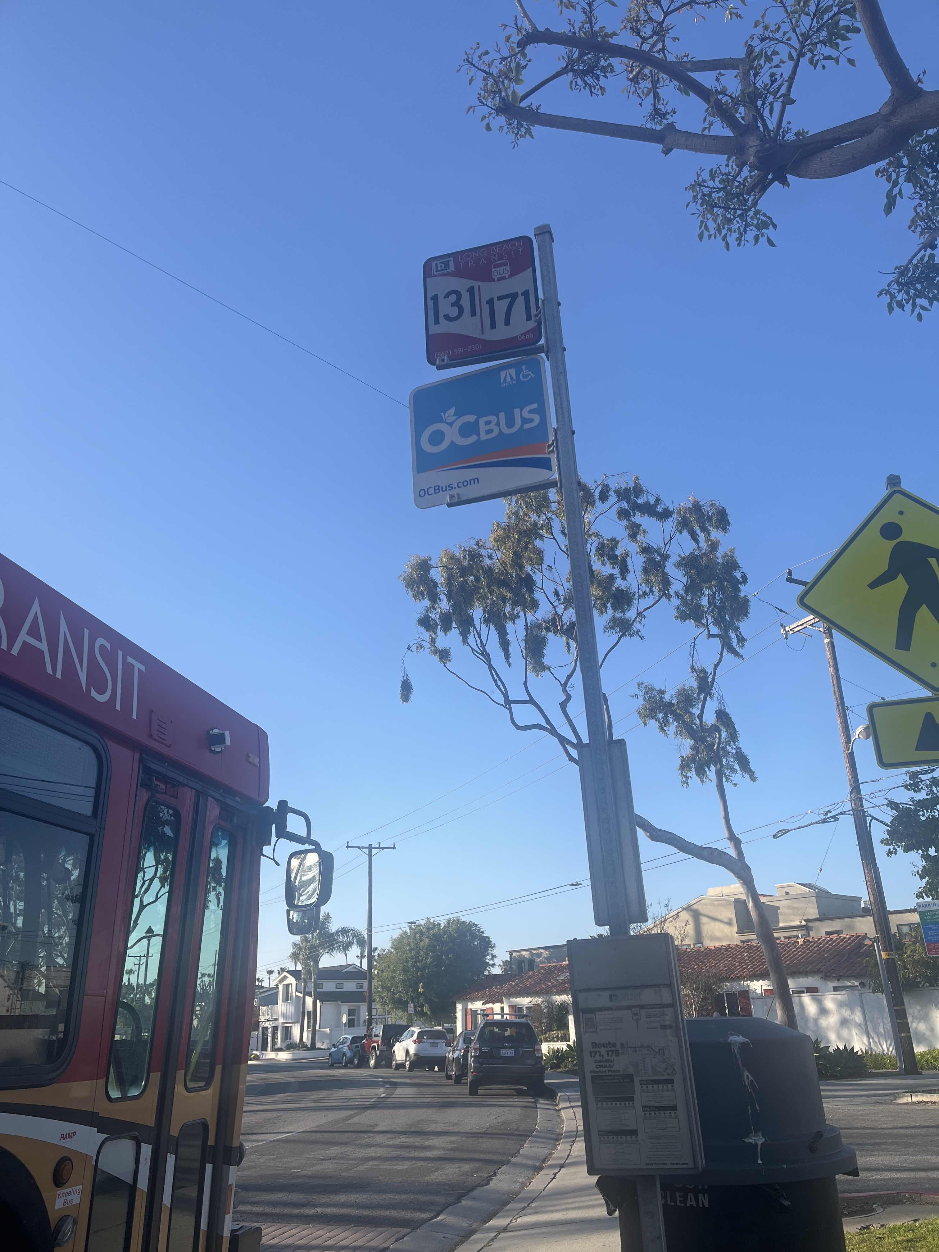 Taken by Anonymous
See Electric & Main NW stop, Seal Beach, on the map
Public transit to Electric & Main NW stop (ID: 0666) in Seal Beach
Looking for directions to Electric & Main NW in Seal Beach, United States?
Download the Moovit App to find the current schedule and step-by-step directions for Bus routes that pass through Electric & Main NW.
Looking for the nearest stops closest to Electric & Main NW ? Check out this list of closest stops to your destination: Electric-Main; Electric & 7th NW; Pacific Coast-Bolsa.
Bus: 1, 171, 46.
We make riding on public transit to Electric & Main NW easy, which is why over 1.5 million users, including users in Seal Beach trust Moovit as the best app for public transit.
Use the app to navigate to popular places including to the airport, hospital, stadium, grocery store, mall, coffee shop, school, college, and university.
Electric & Main NW stop’s code is 0666
The first line to this stop is 171, at 6:58 AM, and the last line is 171 at 10:25 PM.
Electric Avenue, Seal Beach, CA, USA
This stop serves Long Beach Transit’s lines
- Electric-Main,
- Electric & 7th NW,
- Pacific Coast-Bolsa
Bus stops near Electric & Main NW stop
- Hawthorne Blvd & 154th St,
- Golden Lantern-Dana Point Harbor,
- Central / Alondra,
- Pacific / Florence,
- Figueroa St and 8th St E,
- Snow Valley Mountain Resort - Hwy 18,
- Redondo Beach Station,
- Roscoe / Canoga,
- 8th / Irolo,
- Harbor Blvd at Disneyland,
- Figueroa St & Adams Blvd,
- Santa Monica / Vista,
- Atlantic / Sevilla,
- Burbank Blvd & Laurel Canyon Blvd (Eastbound),
- Crafton Hills College,
- 1st St and Hill E,
- Avalon / Carson Mall,
- State & Los Olivos,
- Roxford / Glenoaks,
- Olympic / Atlantic
Popular public transit stations in Seal Beach
Get around Seal Beach by public transit!
Traveling around Seal Beach has never been so easy. See step by step directions as you travel to any attraction, street or major public transit station. View bus and train schedules, arrival times, service alerts and detailed routes on a map, so you know exactly how to get to anywhere in Seal Beach.
When traveling to any destination around Seal Beach use Moovit's Live Directions with Get Off Notifications to know exactly where and how far to walk, how long to wait for your line, and how many stops are left. Moovit will alert you when it's time to get off — no need to constantly re-check whether yours is the next stop.
Wondering how to use public transit in Seal Beach or how to pay for public transit in Seal Beach? Moovit public transit app can help you navigate your way with public transit easily, and at minimum cost. It includes public transit fees, ticket prices, and costs. Looking for a map of Seal Beach public transit lines? Moovit public transit app shows all public transit maps in Seal Beach with all Bus, Train, Subway, Ferry and Funicular routes and stops on an interactive map.
Los Angeles has 5 transit type(s), including: Bus, Train, Subway, Ferry and Funicular, operated by several transit agencies, including Metro, Alhambra Community Transit, Arcadia Transit, ART, Artesia Transit, AVTA, Baldwin Park Transit, Beach Cities Transit, Beaumont Transit, Bell Gardens Town Trolley, Bellflower Bus, Big Blue Bus, Burbank Bus, Calabasas Trolley and Camarillo Area Transit