Directions to Fields West (Boston) with public transportation
The following transit lines have routes that pass near Fields West
 Bus: 501, 64, 66, 57, GREEN LINE B SHUTTLE.
- Train: FRAMINGHAM/WORCESTER.
- Subway: GREEN LINE B.
How to get to Fields West by bus?
Click on the bus route to see step by step directions with maps, line arrival times and updated time schedules.
From Hotel Indigo Boston Garden an IHG Hotel, Boston
49 minFrom Charles/MGH T Stop, Boston
46 minFrom Lower Mills, Boston
88 minFrom Envoy Hotel, Boston
46 minFrom Massport Bus 77 Chelsea Employee Parking, Chelsea
69 minFrom Bova's Bakery, Boston
51 minFrom Malden, MA, Malden
92 minFrom Medford, MA, Medford
72 minFrom TownePlace Suites Boston Logan Airport/Chelsea, Chelsea
69 minFrom Canobie Lake Park, Chelsea
78 min
How to get to Fields West by train?
Click on the train route to see step by step directions with maps, line arrival times and updated time schedules.
How to get to Fields West by subway?
Click on the subway route to see step by step directions with maps, line arrival times and updated time schedules.
From Hotel Indigo Boston Garden an IHG Hotel, Boston
47 minFrom Charles/MGH T Stop, Boston
42 minFrom Lower Mills, Boston
75 minFrom Envoy Hotel, Boston
53 minFrom Massport Bus 77 Chelsea Employee Parking, Chelsea
65 minFrom Bova's Bakery, Boston
48 minFrom Malden, MA, Malden
67 minFrom Medford, MA, Medford
78 minFrom TownePlace Suites Boston Logan Airport/Chelsea, Chelsea
65 min
Bus stops near Fields West in Boston
Subway station near Fields West in Boston
- Packards Corner, 9 min walk,VIEW
Bus lines to Fields West in Boston
- 57, Oak Square,VIEW
- 66, Nubian Via Allston,VIEW
- GREEN LINE B SHUTTLE, Back Bay (Shuttle),VIEW
- SHUTTLE, Kenmore (Shuttle),VIEW
- GREEN LINE B SHUTTLE, Boston College - Babcock Street,VIEW
- GREEN LINE B SHUTTLE, Boston College - Blandford Street,VIEW
- GREEN LINE B SHUTTLE, Washington Street - Kenmore,VIEW
- GREEN LINE B SHUTTLE, Washington Street - Blandford Street,VIEW
- GREEN LINE B SHUTTLE, Boston College - Packard's Corner,VIEW
What are the closest stations to Fields West?
The closest stations to Fields West are:
- Brighton Ave @ Harvard Ave is 178 yards away, 3 min walk.
- Harvard Ave @ Brighton Ave is 220 yards away, 3 min walk.
- Harvard Ave - Commonwealth Ave @ Linden St is 293 yards away, 4 min walk.
- Harvard Avenue - Commonwealth Ave @ Harvard Ave is 303 yards away, 4 min walk.
- Packards Corner is 689 yards away, 9 min walk.
Which bus lines stop near Fields West?
These bus lines stop near Fields West: 501, 64, 66.
Which train line stops near Fields West?
FRAMINGHAM/WORCESTER (#525 | Worcester)
Which subway line stops near Fields West?
GREEN LINE B (Boston College)
What’s the nearest subway station to Fields West in Boston?
The nearest subway station to Fields West in Boston is Packards Corner. It’s a 9 min walk away.
What’s the nearest bus station to Fields West in Boston?
The nearest bus stations to Fields West in Boston are Brighton Ave @ Harvard Ave and Harvard Ave @ Brighton Ave. The closest one is a 3 min walk away.
What time is the first subway to Fields West in Boston?
The GREEN LINE B is the first subway that goes to Fields West in Boston. It stops nearby at 5:12 AM.
What time is the last subway to Fields West in Boston?
The GREEN LINE B is the last subway that goes to Fields West in Boston. It stops nearby at 2:28 AM.
What time is the first bus to Fields West in Boston?
The 57 is the first bus that goes to Fields West in Boston. It stops nearby at 4:40 AM.
What time is the last bus to Fields West in Boston?
The 66 is the last bus that goes to Fields West in Boston. It stops nearby at 2:23 AM.
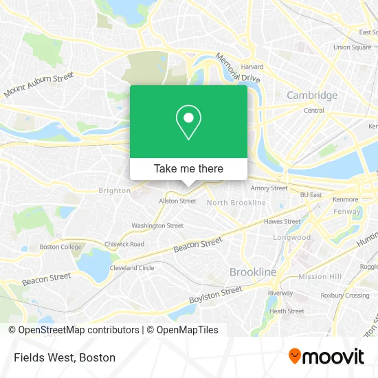
See Fields West, Boston, on the map
Public Transit to Fields West in Boston
Wondering how to get to Fields West in Boston? Moovit helps you find the best way to get to Fields West with step-by-step directions from the nearest public transit station.
Moovit provides free maps and live directions to help you navigate through your city. View schedules, routes, timetables, and find out how long does it take to get to Fields West in real time.
Looking for the nearest stop or station to Fields West? Check out this list of stops closest to your destination: Brighton Ave @ Harvard Ave; Harvard Ave @ Brighton Ave; Harvard Ave - Commonwealth Ave @ Linden St; Harvard Avenue - Commonwealth Ave @ Harvard Ave; Packards Corner.
Bus: 501, 64, 66, 57, GREEN LINE B SHUTTLE, SHUTTLE, GREEN LINE B SHUTTLE, GREEN LINE B SHUTTLE, GREEN LINE B SHUTTLE, GREEN LINE B SHUTTLE, GREEN LINE B SHUTTLE.Train: FRAMINGHAM/WORCESTER.Subway: GREEN LINE B.
Want to see if there’s another route that gets you there at an earlier time? Moovit helps you find alternative routes or times. Get directions from and directions to Fields West easily from the Moovit App or Website.
We make riding to Fields West easy, which is why over 1.7 million users, including users in Boston, trust Moovit as the best app for public transit. You don’t need to download an individual bus app or train app, Moovit is your all-in-one transit app that helps you find the best bus time or train time available.
For information on prices of subway, bus and train, costs and ride fares to Fields West, please check the Moovit app.
Use the app to navigate to popular places including to the airport, hospital, stadium, grocery store, mall, coffee shop, school, college, and university.
Fields West Address: 87 Glenville Ave street in Boston
- 24 Hr A Emergency Locksmith Service,
- Bee's Knees Supply Company,
- Allston St & Long Ave,
- Jay Liu - Real Estate Broker,
- Emergency 24 7 Cooling Repair,
- Element Brainerd,
- Enzo Matcha Green Tea,
- Volmer's Hair Salon (Volmmer's Hair Cutting),
- Edge Allston,
- Eliot Street,
- 2 Feneno ter Parking,
- Palestinian Cultural Center,
- Laserhere,
- Allston,
- Aurora Mountain,
- Ritual Arts,
- Buffalo Exchange,
- Navy Federal Credit Union,
- Regeneration Tattoo (Regeneration Records & Tattoo),
- Kelton St Laundry
Places Near Fields West (Boston)
- Seaport District, Boston,
- Boston Medical Center, Boston,
- Boston Children's Hospital, Boston,
- Quincy Market, Boston,
- Mgm Music Hall, Boston,
- Cheers, Boston,
- House Of Blues, Boston,
- Leader Bank Pavilion (Leader Bank Pavillion), Boston,
- Massachusetts General Hospital, Boston,
- Castle Island, Boston,
- Museum Of Science, Boston,
- Boston Common, Boston,
- Faneuil Hall, Boston,
- North End, Boston,
- Isabella Stewart Gardner Museum, Boston,
- Boston Convention & Exhibition Center, Boston,
- Wang Theater, Boston,
- Prudential Center, Boston,
- Td Garden, Boston,
- Wilbur Theatre, Boston
How to get to popular places in Boston with public transit
Get around Boston by public transit!
Traveling around Boston has never been so easy. See step by step directions as you travel to any attraction, street or major public transit station. View bus and train schedules, arrival times, service alerts and detailed routes on a map, so you know exactly how to get to anywhere in Boston.
When traveling to any destination around Boston use Moovit's Live Directions with Get Off Notifications to know exactly where and how far to walk, how long to wait for your line, and how many stops are left. Moovit will alert you when it's time to get off — no need to constantly re-check whether yours is the next stop.
Wondering how to use public transit in Boston or how to pay for public transit in Boston? Moovit public transit app can help you navigate your way with public transit easily, and at minimum cost. It includes public transit fees, ticket prices, and costs. Looking for a map of Boston public transit lines? Moovit public transit app shows all public transit maps in Boston with all Bus, Train, Subway and Ferry routes and stops on an interactive map.
Boston has 4 transit type(s), including: Bus, Train, Subway and Ferry, operated by several transit agencies, including MBTA, Southeastern Regional Transit Authority, MetroWest Regional Transit Authority, Rhode Island Public Transit Authority, WRTA, Lowell Regional Transit Authority, Merrimack Valley Transit, Montachusett Regional Transit Authority, Cape Cod Regional Transit Authority, Brockton Area Transit Authority, Martha's Vineyard Transit Authority, the WAVE - Nantucket Regional Transit Authority, GATRA, Cape Ann Transportation Authority and Massport