See Francia Plantation, Saint George, on the map
Directions to Francia Plantation (Saint George) with public transportation
The following transit lines have routes that pass near Francia Plantation
 Bus:
Bus:
How to get to Francia Plantation by bus?
Click on the bus route to see step by step directions with maps, line arrival times and updated time schedules.
Bus stations near Francia Plantation in Saint George
- Flat Rock,15 min walk,
- Taitt Hill,18 min walk,
- Glebe Polyclinic,25 min walk,
Bus lines to Francia Plantation in Saint George
- 8F,Fairchild Street Terminal To Flat Rock,
- 7,Fairchild Street Terminal To Sargeant Street,
- 31,Silver Sands To St. George Church,
- 7A,Fairchild Street Terminal To Bowmanston,
- 7B,Princess Alice Terminal To Bath,
- 8B,Workmans To Fairchild Street Terminal,
- SE 9A,Weymouth To College Savannah/Sargeant Street Via Fortesque,
- 8AB,Greens & St. Judes To Fairchild Street Terminal,
What are the closest stations to Francia Plantation?
The closest stations to Francia Plantation are:
- Flat Rock is 1141 meters away, 15 min walk.
- Taitt Hill is 1372 meters away, 18 min walk.
- Glebe Polyclinic is 1901 meters away, 25 min walk.
Which bus lines stop near Francia Plantation?
These bus lines stop near Francia Plantation: 31, 7, 8B, 8F.
What’s the nearest bus stop to Francia Plantation in Saint George?
The nearest bus stop to Francia Plantation in Saint George is Flat Rock. It’s a 15 min walk away.
What time is the first bus to Francia Plantation in Saint George?
The 7A is the first bus that goes to Francia Plantation in Saint George. It stops nearby at 5:16 AM.
What time is the last bus to Francia Plantation in Saint George?
The 7 is the last bus that goes to Francia Plantation in Saint George. It stops nearby at 12:21 AM.
See Francia Plantation, Saint George, on the map
Public Transit to Francia Plantation in Saint George
Wondering how to get to Francia Plantation in Saint George, Barbados? Moovit helps you find the best way to get to Francia Plantation with step-by-step directions from the nearest public transit station.
Moovit provides free maps and live directions to help you navigate through your city. View schedules, routes, timetables, and find out how long does it take to get to Francia Plantation in real time.
Looking for the nearest stop or station to Francia Plantation? Check out this list of stops closest to your destination: Flat Rock; Taitt Hill; Glebe Polyclinic.
Bus:
Want to see if there’s another route that gets you there at an earlier time? Moovit helps you find alternative routes or times. Get directions from and directions to Francia Plantation easily from the Moovit App or Website.
We make riding to Francia Plantation easy, which is why over 1.5 million users, including users in Saint George, trust Moovit as the best app for public transit. You don’t need to download an individual bus app or train app, Moovit is your all-in-one transit app that helps you find the best bus time or train time available.
For information on prices of bus, costs and ride fares to Francia Plantation, please check the Moovit app.
Use the app to navigate to popular places including to the airport, hospital, stadium, grocery store, mall, coffee shop, school, college, and university.
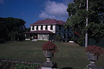
Francia Plantation Address: Francia Road street in Saint George
Francia Great House is a historical plantation great house in Saint George, Barbados. It is on a wooded hillside near Gun Hill Signal Station.Wiki
Attractions near Francia Plantation
Francia Plantation,Providence Elementary School,Providence School Barbados - Elementary,Providence Secondary School,#Hoganlovellsdc,Thorpes Cottage Church Of the Nazarene,Market Hill Supermarket,Rezult Auto Shop (Market HIll),Monica London,Gun Hill Signal Station,The Glebe Polyclinic,Gun Hill,Victory Pentecostal Church Of God,Walkers Terrace,Soothing Touch da Spa,Corky's Garage,Flat Rock,Rowans,Glebe Polyclinic,WalkersHow to get to popular attractions in Saint George with public transit
Boardwalk, Bridgetown,Royal Westmoreland Resort, Saint James,Collins Limited Wholesale, Saint Michael,Codrington College, Saint John,Welches, Christ Church,Bridgetown Harbour, Bridgetown,The Barbados Light & Power Co., Bridgetown,Maxwell Main Road, Christ Church,Spring Garden, Bridgetown,Gibbes beach, Barbados,Deighton Griffith Secondary School, Christ Church,Colony Club Hotel, Saint James,Esso Gas Station Culloden Rd, Bridgetown,Blakey's on the Boardwalk, Bridgetown,Ace H & B Hardware, Saint Michael,Massy Stores- Supermarket, Saint Michael,Emerald City Complex, Saint Philip,Central Bank of Barbados, Bridgetown,Maxwell Beach, Christ Church,Harbour Road, BridgetownGet around Saint George by public transit!
Traveling around Saint George has never been so easy. See step by step directions as you travel to any attraction, street or major public transit station. View bus and train schedules, arrival times, service alerts and detailed routes on a map, so you know exactly how to get to anywhere in Saint George.
When traveling to any destination around Saint George use Moovit's Live Directions with Get Off Notifications to know exactly where and how far to walk, how long to wait for your line, and how many stops are left. Moovit will alert you when it's time to get off — no need to constantly re-check whether yours is the next stop.
Wondering how to use public transit in Saint George or how to pay for public transit in Saint George? Moovit public transit app can help you navigate your way with public transit easily, and at minimum cost. It includes public transit fees, ticket prices, and costs. Looking for a map of Saint George public transit lines? Moovit public transit app shows all public transit maps in Saint George with all bus routes and stops on an interactive map.
Saint George has 1 transit type(s), including: bus, operated by several transit agencies, including Transport Board