See Frederick Douglass National Historic Site, Washington, on the map
under the digital ID hhh.dc0092.
This tag does not indicate the copyright status of the attached work. A normal copyright tag is still required. See Commons:Licensing for more information.
Directions to Frederick Douglass National Historic Site (Washington) with public transportation
The following transit lines have routes that pass near Frederick Douglass National Historic Site
 Bus:
Bus: - Metro:
How to get to Frederick Douglass National Historic Site by bus?
Click on the bus route to see step by step directions with maps, line arrival times and updated time schedules.
How to get to Frederick Douglass National Historic Site by metro?
Click on the metro route to see step by step directions with maps, line arrival times and updated time schedules.
Which bus lines stop near Frederick Douglass National Historic Site?
These bus lines stop near Frederick Douglass National Historic Site: 90, B2, P6.
Which metro line stops near Frederick Douglass National Historic Site?
METRORAIL GREEN LINE
See Frederick Douglass National Historic Site, Washington, on the map
under the digital ID hhh.dc0092.
This tag does not indicate the copyright status of the attached work. A normal copyright tag is still required. See Commons:Licensing for more information.
Public Transit to Frederick Douglass National Historic Site in Washington
Wondering how to get to Frederick Douglass National Historic Site in Washington, United States? Moovit helps you find the best way to get to Frederick Douglass National Historic Site with step-by-step directions from the nearest public transit station.
Moovit provides free maps and live directions to help you navigate through your city. View schedules, routes, timetables, and find out how long does it take to get to Frederick Douglass National Historic Site in real time.
Bus:Metro:
Want to see if there’s another route that gets you there at an earlier time? Moovit helps you find alternative routes or times. Get directions from and directions to Frederick Douglass National Historic Site easily from the Moovit App or Website.
We make riding to Frederick Douglass National Historic Site easy, which is why over 1.5 million users, including users in Washington, trust Moovit as the best app for public transit. You don’t need to download an individual bus app or train app, Moovit is your all-in-one transit app that helps you find the best bus time or train time available.
For information on prices of bus and metro, costs and ride fares to Frederick Douglass National Historic Site, please check the Moovit app.
Use the app to navigate to popular places including to the airport, hospital, stadium, grocery store, mall, coffee shop, school, college, and university.
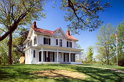
Frederick Douglass National Historic Site Address: W Street Southeast street in Washington
under the digital ID hhh.dc0092.
This tag does not indicate the copyright status of the attached work. A normal copyright tag is still required. See Commons:Licensing for more information.
Attractions near Frederick Douglass National Historic Site
1411 W Street Southeast,Douglass Memorial Home,Frederick Douglass Home Visitor Center,Emergency Locksmith of Washington,1,Frederick Douglass Wohnhaus,Van Hook Mansion,Cedar Hill,Maison de Frederick Douglass,John Van Hook House,Frederick Douglass Home,Frederick Douglass National Historic Site (NHS),1416,W St W St SE,W St SE (14th and W St),W St SE ,W St,High St SE ,Dc Prep Pcs Anacostia Elementary Campus,Saint Teresa School,1500 W St SEHow to get to popular attractions in Washington with public transit
Damascus, MD, Montgomery County,P.J. Clarke's, Washington,Odenton MARC Station, Anne Arundel County,Maryland State Fairgrounds, Baltimore County,Federal Center SW Metro Station, Washington,Hard Rock Cafe Washington DC, Washington,Columbia, MD, Howard County,Dumfries, VA, Prince William County,Sweetwater Tavern, Fairfax County,Baltimore Farmers' Market & Bazaar, Baltimore,Little Havana, Baltimore,The Hippodrome Theatre at the France-Merrick Performing Arts Center, Baltimore,The Greene Turtle Sports Bar & Grille, Washington,Renaissance Baltimore Harborplace Hotel, Baltimore,Hamilton's Bar & Grill, Washington,Gordon Biersch Brewery Restaurant, Fairfax County,G&M Restaurant and Lounge, Anne Arundel County,Bistrot Du Coin, Washington,Hyatt Regency Reston, Fairfax County,Bureau of Engraving and Printing, WashingtonGet around Washington by public transit!
Traveling around Washington has never been so easy. See step by step directions as you travel to any attraction, street or major public transit station. View bus and train schedules, arrival times, service alerts and detailed routes on a map, so you know exactly how to get to anywhere in Washington.
When traveling to any destination around Washington use Moovit's Live Directions with Get Off Notifications to know exactly where and how far to walk, how long to wait for your line, and how many stops are left. Moovit will alert you when it's time to get off — no need to constantly re-check whether yours is the next stop.
Wondering how to use public transit in Washington or how to pay for public transit in Washington? Moovit public transit app can help you navigate your way with public transit easily, and at minimum cost. It includes public transit fees, ticket prices, and costs. Looking for a map of Washington public transit lines? Moovit public transit app shows all public transit maps in Washington with all bus or metro routes and stops on an interactive map.
Washington has 2 transit type(s), including: bus or metro, operated by several transit agencies, including WMATA, WMATA, Montgomery County Ride On, Fairfax Connector, TheBus, DC Circulator, MDOT MTA, Marc, MDOT MTA, MDOT MTA, Virginia Railway Express (VRE), PRTC, DASH - Alexandria, Arlington Transit (ART) and DC Streetcar