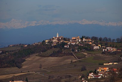
See Golferenzo on the map
Directions to Golferenzo with public transportation
The following transit lines have routes that pass near Golferenzo
 Bus:
Bus:
How to get to Golferenzo by bus?
Click on the bus route to see step by step directions with maps, line arrival times and updated time schedules.
Bus stations near Golferenzo
- Montecalvo V. - Croce Bianca - Sp201,13 min walk,
Bus lines to Golferenzo
- 85,Romagnese - Roma (Pesa),
What are the closest stations to Golferenzo?
The closest stations to Golferenzo are:
- Montecalvo V. - Croce Bianca - Sp201 is 956 meters away, 13 min walk.
Which bus lines stop near Golferenzo?
These bus lines stop near Golferenzo: 185, 85.
What’s the nearest bus stop to Golferenzo?
The nearest bus stop to Golferenzo is Montecalvo V. - Croce Bianca - Sp201. It’s a 13 min walk away.
How much is the bus fare to Golferenzo?
The bus fare to Golferenzo costs about €1.40 - €1.80.
How much is the train fare to Golferenzo?
The train fare to Golferenzo costs about €1.40 - €7.40.
See Golferenzo on the map
Public Transportation to Golferenzo
Wondering how to get to Golferenzo, Italy? Moovit helps you find the best way to get to Golferenzo with step-by-step directions from the nearest public transit station.
Moovit provides free maps and live directions to help you navigate through your city. View schedules, routes, timetables, and find out how long does it take to get to Golferenzo in real time.
Looking for the nearest stop or station to Golferenzo? Check out this list of stops closest to your destination: Montecalvo V. - Croce Bianca - Sp201.
Bus:
Want to see if there’s another route that gets you there at an earlier time? Moovit helps you find alternative routes or times. Get directions from and directions to Golferenzo easily from the Moovit App or Website.
We make riding to Golferenzo easy, which is why over 1.5 million users, including users in Golferenzo, trust Moovit as the best app for public transit. You don’t need to download an individual bus app or train app, Moovit is your all-in-one transit app that helps you find the best bus time or train time available.
For information on prices of bus and train, costs and ride fares to Golferenzo, please check the Moovit app.
Use the app to navigate to popular places including to the airport, hospital, stadium, grocery store, mall, coffee shop, school, college, and university.
Location: Golferenzo, Milan and Lombardy
Attractions near Golferenzo
Podere Scabini,Qua da Noi,Borelli Group,Soc Agr Casa,La Torretta di Sotto, Oasi e Country House,Soriasco,Scarabelli di Scarabelli Daniele,Scarabelli Daniele Azienda Agricola - Scara Wines,Antichi Sapori Toscani,Azagr. Beltrami Fratelli Eredi D,Montecalvo Versiggia,Servizi Demografici,Comune di Montecalvo Versiggia,Il Garage Terzoni di Terzoni Gianluca,Azienda Agricola Dezza Dario di Dezza Daniele,Il Nespolo B&B,Gi.La. di Biscardi Luigi,La Rocca degli Angeli Onlus,Salumifico Casa Chiesa,Centro Sportivo Comunale di Montecalvo VersiggiaHow to get to popular attractions in Golferenzo with public transit
Piazza 24 Maggio, Milano,Azienda Socio Sanitaria Territoriale degli Spedali Civili di Brescia, Brescia,Ikea Deposito, Carugate,Università Bicocca - Scienza, Milano,Università Bocconi, Milano,Via Ripamonti - Via Quaranta, Milano,Piazza Tricolore, Milano,Centro Commerciale Cremona Po, Cremona,Teatro Degli Arcimboldi, Milano,Piazza Fontana, Milano,Piazza Leonardo Da Vinci - Politecnico, Milano,Cologno Monzese, Milano,Yoox Net-à-Porter S.p.A., Milano,Eni 7° Palazzo Uffici, San Donato Milanese,Piazza Napoli, Milano,P.le Cantore, Milano,Università Cattolica Del Sacro Cuore, Milano,Corbetta, Corbetta,Area di Servizio Brembo Sud, Osio Sopra,Metro Piola (M2), MilanoGet around Golferenzo by public transit!
Traveling around Golferenzo has never been so easy. See step by step directions as you travel to any attraction, street or major public transit station. View bus and train schedules, arrival times, service alerts and detailed routes on a map, so you know exactly how to get to anywhere in Golferenzo.
When traveling to any destination around Golferenzo use Moovit's Live Directions with Get Off Notifications to know exactly where and how far to walk, how long to wait for your line, and how many stops are left. Moovit will alert you when it's time to get off — no need to constantly re-check whether yours is the next stop.
Wondering how to use public transit in Golferenzo or how to pay for public transit in Golferenzo? Moovit public transit app can help you navigate your way with public transit easily, and at minimum cost. It includes public transit fees, ticket prices, and costs. Looking for a map of Golferenzo public transit lines? Moovit public transit app shows all public transit maps in Golferenzo with all bus or train routes and stops on an interactive map.
Golferenzo has 2 transit type(s), including: bus or train, operated by several transit agencies, including ATM, ATM, ATM, Trenord, Trenitalia, Autoguidovie S.p.A., NET, Movibus, ATM, ASF Autolinee, Autostradale S.r.l., Terravision, AirPullman, TEB and ATB