See Gresham City Hall, Portland, OR, on the map
Directions to Gresham City Hall (Portland, OR) with public transportation
The following transit lines have routes that pass near Gresham City Hall
 Bus:
Bus: - Light Rail:
How to get to Gresham City Hall by bus?
Click on the bus route to see step by step directions with maps, line arrival times and updated time schedules.
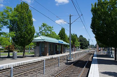
Light Rail stations near Gresham City Hall in Portland, OR
- Gresham City Hall,2 min walk,
Bus stations near Gresham City Hall in Portland, OR
- 1300 Block Nw Eastman (South),2 min walk,
Bus lines to Gresham City Hall in Portland, OR
- 21,NE Sandy & Parkrose Transit Center (West),
What are the closest stations to Gresham City Hall?
The closest stations to Gresham City Hall are:
- Gresham City Hall is 75 yards away, 2 min walk.
- 1300 Block Nw Eastman (South) is 89 yards away, 2 min walk.
Which bus lines stop near Gresham City Hall?
These bus lines stop near Gresham City Hall: 4, 9.
Which light rail line stops near Gresham City Hall?
MAX BLUE LINE
What’s the nearest light rail station to Gresham City Hall in Portland, OR?
The nearest light rail station to Gresham City Hall in Portland, OR is Gresham City Hall. It’s a 2 min walk away.
What’s the nearest bus stop to Gresham City Hall in Portland, OR?
The nearest bus stop to Gresham City Hall in Portland, OR is 1300 Block Nw Eastman (South). It’s a 2 min walk away.
See Gresham City Hall, Portland, OR, on the map
Public Transit to Gresham City Hall in Portland, OR
Wondering how to get to Gresham City Hall in Portland, OR, United States? Moovit helps you find the best way to get to Gresham City Hall with step-by-step directions from the nearest public transit station.
Moovit provides free maps and live directions to help you navigate through your city. View schedules, routes, timetables, and find out how long does it take to get to Gresham City Hall in real time.
Looking for the nearest stop or station to Gresham City Hall? Check out this list of stops closest to your destination: Gresham City Hall; 1300 Block Nw Eastman (South).
Bus:Light Rail:
Want to see if there’s another route that gets you there at an earlier time? Moovit helps you find alternative routes or times. Get directions from and directions to Gresham City Hall easily from the Moovit App or Website.
We make riding to Gresham City Hall easy, which is why over 1.5 million users, including users in Portland, OR, trust Moovit as the best app for public transit. You don’t need to download an individual bus app or train app, Moovit is your all-in-one transit app that helps you find the best bus time or train time available.
For information on prices of bus and light rail, costs and ride fares to Gresham City Hall, please check the Moovit app.
Use the app to navigate to popular places including to the airport, hospital, stadium, grocery store, mall, coffee shop, school, college, and university.
Location: Portland, OR
Attractions near Gresham City Hall
Hartley Elementary School,Kirk Park,Salish Ponds Elementary School,Woodland Elementary School,Rockwood Substation,Marilyn's Park,76,Donald L. Robertson City Park,Safeway 1269,Shari's,Eastrose Fellowship,Reynolds Learning Academy,Reynolds Middle School,Christ Light Unity Church,Salish Ponds Park,Indian John Park,Target,Fairview Post Office,Crossroads Park,Fairview-Columbia LibraryHow to get to popular attractions in Portland, OR with public transit
Cully Neighborhood, Portland,Oregon Convention Center, Portland,Residence Inn Portland Airport at Cascade Station, Portland,Nike - Dan Fouts Building,TriMet E 181st Ave MAX Station, Gresham,Washington Square Mall, Tigard,Kaiser Permanente Building, Portland,Trimet South Waterfront / SW Moody MAX Station, Portland,5 Corners, Five Corners,Moda Center, Portland,Nike - Jerry Rice Building,Ringlers Pub, Portland,Mid-K Beauty Supply Store, Portland,Intel - Amberglen Campus, Hillsboro,WinCo Foods, Gresham,Highway 26 & 185th Street, Hillsboro,TriMet SE Fuller Rd MAX Station,TriMet Washington / SE 12th Ave MAX Station, Hillsboro,McCormick & Schmick's Harborside at the Marina, Portland,Tanasbourne, HillsboroGet around Portland, OR by public transit!
Traveling around Portland, OR has never been so easy. See step by step directions as you travel to any attraction, street or major public transit station. View bus and train schedules, arrival times, service alerts and detailed routes on a map, so you know exactly how to get to anywhere in Portland, OR.
When traveling to any destination around Portland, OR use Moovit's Live Directions with Get Off Notifications to know exactly where and how far to walk, how long to wait for your line, and how many stops are left. Moovit will alert you when it's time to get off — no need to constantly re-check whether yours is the next stop.
Wondering how to use public transit in Portland, OR or how to pay for public transit in Portland, OR? Moovit public transit app can help you navigate your way with public transit easily, and at minimum cost. It includes public transit fees, ticket prices, and costs. Looking for a map of Portland, OR public transit lines? Moovit public transit app shows all public transit maps in Portland, OR with all bus or light rail routes and stops on an interactive map.
Portland, OR has 2 transit type(s), including: bus or light rail, operated by several transit agencies, including Mount Adams Transportation Service, RiverCities Transit, TriMet , TriMet , TriMet, Portland Streetcar, Portland Aerial Tram, C-TRAN, Multnomah County Job Connector Shuttles, Washington Park Shuttle, SMART, Canby Area Transit, South Clackamas Transportation District, The Wave and Lincoln County Transit