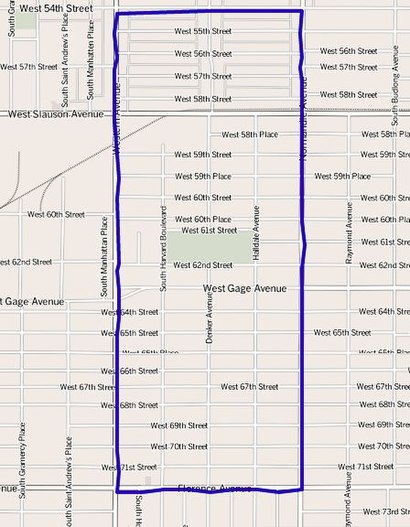
See Harvard Park, Harvard Park, La, on the map
Directions to Harvard Park (Harvard Park, La) with public transportation
The following transit lines have routes that pass near Harvard Park
 Bus:
Bus:
How to get to Harvard Park by bus?
Click on the bus route to see step by step directions with maps, line arrival times and updated time schedules.
Bus stations near Harvard Park in Harvard Park, La
- Gage / Denker,3 min walk,
- Western / 62nd,6 min walk,
- Normandie / Gage,8 min walk,
Light Rail stations near Harvard Park in Harvard Park, La
- Fairview Heights Station,31 min walk,
- Expo / Western,37 min walk,
Bus lines to Harvard Park in Harvard Park, La
- 110,Playa Vista,
- 207,Western - Imperial Highway,
- 206,Vermont / Athens Station,
What are the closest stations to Harvard Park?
The closest stations to Harvard Park are:
- Gage / Denker is 155 yards away, 3 min walk.
- Western / 62nd is 477 yards away, 6 min walk.
- Normandie / Gage is 588 yards away, 8 min walk.
- Fairview Heights Station is 2595 yards away, 31 min walk.
- Expo / Western is 3061 yards away, 37 min walk.
Which bus lines stop near Harvard Park?
These bus lines stop near Harvard Park: 108, 110, 206, 207.
What’s the nearest bus stop to Harvard Park in Harvard Park, La?
The nearest bus stop to Harvard Park in Harvard Park, La is Gage / Denker. It’s a 3 min walk away.
What time is the first light rail to Harvard Park in Harvard Park, La?
The E LINE (EXPO) is the first light rail that goes to Harvard Park in Harvard Park, La. It stops nearby at 3:50 AM.
What time is the last light rail to Harvard Park in Harvard Park, La?
The METRO K LINE (CRENSHAW) is the last light rail that goes to Harvard Park in Harvard Park, La. It stops nearby at 12:48 AM.
What time is the first bus to Harvard Park in Harvard Park, La?
The 207 is the first bus that goes to Harvard Park in Harvard Park, La. It stops nearby at 3:19 AM.
What time is the last bus to Harvard Park in Harvard Park, La?
The 207 is the last bus that goes to Harvard Park in Harvard Park, La. It stops nearby at 2:45 AM.
How much is the bus fare to Harvard Park?
The bus fare to Harvard Park costs about $1.00 - $1.75.
See Harvard Park, Harvard Park, La, on the map
Public Transit to Harvard Park in Harvard Park, La
Wondering how to get to Harvard Park in Harvard Park, La, United States? Moovit helps you find the best way to get to Harvard Park with step-by-step directions from the nearest public transit station.
Moovit provides free maps and live directions to help you navigate through your city. View schedules, routes, timetables, and find out how long does it take to get to Harvard Park in real time.
Looking for the nearest stop or station to Harvard Park? Check out this list of stops closest to your destination: Gage / Denker; Western / 62nd; Normandie / Gage; Fairview Heights Station; Expo / Western.
Bus:
Want to see if there’s another route that gets you there at an earlier time? Moovit helps you find alternative routes or times. Get directions from and directions to Harvard Park easily from the Moovit App or Website.
We make riding to Harvard Park easy, which is why over 1.5 million users, including users in Harvard Park, La, trust Moovit as the best app for public transit. You don’t need to download an individual bus app or train app, Moovit is your all-in-one transit app that helps you find the best bus time or train time available.
For information on prices of bus, costs and ride fares to Harvard Park, please check the Moovit app.
Use the app to navigate to popular places including to the airport, hospital, stadium, grocery store, mall, coffee shop, school, college, and university.
Harvard Park Address: West 61st Street street in Harvard Park, La
Harvard Park is a 0.64-square-mile neighborhood in the South Los Angeles region of Los Angeles, California. It is centered on a municipal park by that name.Wiki
Attractions near Harvard Park
1502 W 62nd Apts,6215 S Harvard Blvd Apts,1512 1/2 W 60th St Apts,D N J's Delivery Service,6100 S Hobart Blvd Apts,Doc Boy Records,Alex Plumbing Repair,MCM Meat Market,6050 S Western Ave Apts,Amistad Plaza Partners,Calderon Tires & Wheels Center,Umana's Painting,Atm,U-Haul,Long Beach Towing,Facts Education Fund,Staying in the Word,Knowles Insurance Services,Business Enterprise Center,Teamwork Team StudiosHow to get to popular attractions in Harvard Park, La with public transit
Anaheim GardenWalk, Anaheim,Montclair Place, Montclair,It's a Small World, Anaheim,East Shuttle Area, Anaheim,Six Flags Magic Mountain, Santa Susana Mountains, La,Saddleback Community College, Mission Viejo,LA Fitness, Santa Clarita,Hollywood Burbank Airport (BUR), Burbank,Hyatt Regency Orange County, Garden Grove,Whole Foods Market, Tustin,Costco Wholesale, Northridge, La,City of Calabasas, Calabasas,Temecula Promenade Mall, Temecula,City of Simi Valley, Simi Valley,City of Anaheim, Anaheim,Indiana Jones Adventure, Anaheim,The Hollywood Bowl, Hollywood Hills, La,City of Rancho Cucamonga, Rancho Cucamonga,Torrance, CA, Torrance,Citadel Outlets, CommerceGet around Harvard Park, La by public transit!
Traveling around Harvard Park, La has never been so easy. See step by step directions as you travel to any attraction, street or major public transit station. View bus and train schedules, arrival times, service alerts and detailed routes on a map, so you know exactly how to get to anywhere in Harvard Park, La.
When traveling to any destination around Harvard Park, La use Moovit's Live Directions with Get Off Notifications to know exactly where and how far to walk, how long to wait for your line, and how many stops are left. Moovit will alert you when it's time to get off — no need to constantly re-check whether yours is the next stop.
Wondering how to use public transit in Harvard Park, La or how to pay for public transit in Harvard Park, La? Moovit public transit app can help you navigate your way with public transit easily, and at minimum cost. It includes public transit fees, ticket prices, and costs. Looking for a map of Harvard Park, La public transit lines? Moovit public transit app shows all public transit maps in Harvard Park, La with all bus routes and stops on an interactive map.
Harvard Park, La has 1 transit type(s), including: bus, operated by several transit agencies, including Metro - Los Angeles, Metro - Los Angeles, Metrolink Trains, METRO, Long Beach Transit, LADOT, OCTA, Foothill Transit, Big Blue Bus, Riverside Transit Agency, LAX FlyAway, Airporter Shuttle, Playa Vista Shuttle, Amtrak and OMNITRANS