See Hillsdale Caltrain Station, San Mateo, on the map
Directions to Hillsdale Caltrain Station (San Mateo) with public transportation
The following transit lines have routes that pass near Hillsdale Caltrain Station
 Bus:
Bus: - Train:
How to get to Hillsdale Caltrain Station by bus?
Click on the bus route to see step by step directions with maps, line arrival times and updated time schedules.
How to get to Hillsdale Caltrain Station by train?
Click on the train route to see step by step directions with maps, line arrival times and updated time schedules.
Bus stations near Hillsdale Caltrain Station in San Mateo
- 28th Ave & S El Camino Real,3 min walk,
- El Camino Real & 27th Ave,3 min walk,
- El Camino Real & 31st Ave,5 min walk,
- El Camino Real & 31st Ave-Hillsdale Shopping Ctr,8 min walk,
Train stations near Hillsdale Caltrain Station in San Mateo
- Belmont,34 min walk,
- San Mateo,54 min walk,
Bus lines to Hillsdale Caltrain Station in San Mateo
- 51,Foster City - Hillsdale HS,
- 57,Edgewater/Beach Park - Hillsdale High,
- 294,Hillsdale - Half Moon Bay,
- ECR,Palo Alto Transit Center,
- 397,San Francisco,
- 251,Foster City - Hillsdale,
- 250,College of San Mateo,
What are the closest stations to Hillsdale Caltrain Station?
The closest stations to Hillsdale Caltrain Station are:
- 28th Ave & S El Camino Real is 198 yards away, 3 min walk.
- El Camino Real & 27th Ave is 223 yards away, 3 min walk.
- El Camino Real & 31st Ave is 397 yards away, 5 min walk.
- El Camino Real & 31st Ave-Hillsdale Shopping Ctr is 635 yards away, 8 min walk.
- Belmont is 2930 yards away, 34 min walk.
- San Mateo is 4583 yards away, 54 min walk.
Which bus lines stop near Hillsdale Caltrain Station?
These bus lines stop near Hillsdale Caltrain Station: 292, 398, ECR.
Which train lines stop near Hillsdale Caltrain Station?
These train lines stop near Hillsdale Caltrain Station: BULLET, LOCAL, LTD 3.
What’s the nearest bus stop to Hillsdale Caltrain Station in San Mateo?
The nearest bus stops to Hillsdale Caltrain Station in San Mateo are 28th Ave & S El Camino Real and El Camino Real & 27th Ave. The closest one is a 3 min walk away.
What time is the first train to Hillsdale Caltrain Station in San Mateo?
The LOCAL is the first train that goes to Hillsdale Caltrain Station in San Mateo. It stops nearby at 5:16 AM.
What time is the last train to Hillsdale Caltrain Station in San Mateo?
The LOCAL is the last train that goes to Hillsdale Caltrain Station in San Mateo. It stops nearby at 12:47 AM.
What time is the first bus to Hillsdale Caltrain Station in San Mateo?
The 397 is the first bus that goes to Hillsdale Caltrain Station in San Mateo. It stops nearby at 3:00 AM.
What time is the last bus to Hillsdale Caltrain Station in San Mateo?
The 397 is the last bus that goes to Hillsdale Caltrain Station in San Mateo. It stops nearby at 3:46 AM.
How much is the train fare to Hillsdale Caltrain Station?
The train fare to Hillsdale Caltrain Station costs about $3.20 - $9.95.
How much is the BART fare to Hillsdale Caltrain Station?
The BART fare to Hillsdale Caltrain Station costs about $2.15 - $6.60.
See Hillsdale Caltrain Station, San Mateo, on the map
Public Transit to Hillsdale Caltrain Station in San Mateo
Wondering how to get to Hillsdale Caltrain Station in San Mateo, United States? Moovit helps you find the best way to get to Hillsdale Caltrain Station with step-by-step directions from the nearest public transit station.
Moovit provides free maps and live directions to help you navigate through your city. View schedules, routes, timetables, and find out how long does it take to get to Hillsdale Caltrain Station in real time.
Looking for the nearest stop or station to Hillsdale Caltrain Station? Check out this list of stops closest to your destination: 28th Ave & S El Camino Real; El Camino Real & 27th Ave; El Camino Real & 31st Ave; El Camino Real & 31st Ave-Hillsdale Shopping Ctr; Belmont; San Mateo.
Bus:Train:
Want to see if there’s another route that gets you there at an earlier time? Moovit helps you find alternative routes or times. Get directions from and directions to Hillsdale Caltrain Station easily from the Moovit App or Website.
We make riding to Hillsdale Caltrain Station easy, which is why over 1.5 million users, including users in San Mateo, trust Moovit as the best app for public transit. You don’t need to download an individual bus app or train app, Moovit is your all-in-one transit app that helps you find the best bus time or train time available.
For information on prices of train, bus and BART, costs and ride fares to Hillsdale Caltrain Station, please check the Moovit app.
Use the app to navigate to popular places including to the airport, hospital, stadium, grocery store, mall, coffee shop, school, college, and university.
Location: San Mateo, San Francisco - San Jose, CA
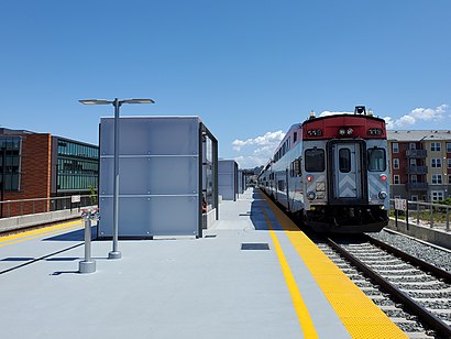
Hillsdale station is one of three Caltrain stations in San Mateo, California. The station is next to the Bay Meadows neighborhood and close to the Hillsdale Shopping Center.Wiki
Attractions near Hillsdale Caltrain Station
Caltrain-Hillsdale,Secure Data Recovery Services,AT&T Communications,Navy Federal Credit Union,Comcast,Desk Company,Body Central,Astound Broadband Powered by Wave,Peter Pan BMW,Nueva School,El Camino Real & 27th Avenue,El Camino Real & 27th Avenue,Eartone Hearing Aid Center,Phillips 66,Heart,Universal Motors,San Mateo Auto Sales,Rocket,The Juggler,Armed Forces Career Recruiting CenterHow to get to popular attractions in San Mateo with public transit
IKEA, East Palo Alto,Silicon Valley, Santa Clara,I-80, Emeryville,Googleplex - 43,Googleplex,Sonoma County Fairgrounds, Santa Rosa,BJ's Restaurant and Brewhouse, Cupertino,Sunnyvale, CA, Sunnyvale,City of Menlo Park, Menlo Park,Fremont BART Station, Fremont,Lawrence Livermore National Laboratory, Livermore,Charles M. Schulz - Sonoma County Airport (STS),Tamien Caltrain Station, San Jose,Microsoft SVC,Googleplex - Crittenden Campus,Walmart Supercenter, Milpitas,Costco Wholesale, Santa Clara,Sonoma State University,Westgate Shopping Center, San Jose,Costco Wholesale, SunnyvaleGet around San Mateo by public transit!
Traveling around San Mateo has never been so easy. See step by step directions as you travel to any attraction, street or major public transit station. View bus and train schedules, arrival times, service alerts and detailed routes on a map, so you know exactly how to get to anywhere in San Mateo.
When traveling to any destination around San Mateo use Moovit's Live Directions with Get Off Notifications to know exactly where and how far to walk, how long to wait for your line, and how many stops are left. Moovit will alert you when it's time to get off — no need to constantly re-check whether yours is the next stop.
Wondering how to use public transit in San Mateo or how to pay for public transit in San Mateo? Moovit public transit app can help you navigate your way with public transit easily, and at minimum cost. It includes public transit fees, ticket prices, and costs. Looking for a map of San Mateo public transit lines? Moovit public transit app shows all public transit maps in San Mateo with all train, bus or BART routes and stops on an interactive map.
San Mateo has 3 transit type(s), including: train, bus or BART, operated by several transit agencies, including BART, Bay Area Rapid Transit, Muni Metro, Caltrain, VTA, Capitol Corridor, Sonoma Marin Area Rail Transit, MUNI, VTA, SF Cable Car, AC Transit, Dumbarton Express, Golden Gate Transit, County Connection and SamTrans