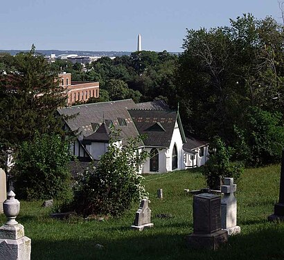
See Holy Rood Cemetery, Washington, on the map
Directions to Holy Rood Cemetery (Washington) with public transportation
The following transit lines have routes that pass near Holy Rood Cemetery
 Bus:
Bus: - Metro:
How to get to Holy Rood Cemetery by bus?
Click on the bus route to see step by step directions with maps, line arrival times and updated time schedules.
How to get to Holy Rood Cemetery by metro?
Click on the metro route to see step by step directions with maps, line arrival times and updated time schedules.
Bus stations near Holy Rood Cemetery in Washington
- 35th Street And Wisconsin Avenue NW (Sb),3 min walk,
- Wisconsin Av Nw+35 St NW,3 min walk,
- 35 St Nw+T St NW,6 min walk,
Metro stations near Holy Rood Cemetery in Washington
- Woodley Park-Zoo/Adams Morgan,18 min walk,
- Rosslyn Metro Station,33 min walk,
Bus lines to Holy Rood Cemetery in Washington
- GT-US,Georgetown,
- 31,South To Potomac Park,
- 33,South To Federal Triangle,
- D2,West To Glover Park,
What are the closest stations to Holy Rood Cemetery?
The closest stations to Holy Rood Cemetery are:
- 35th Street And Wisconsin Avenue NW (Sb) is 174 yards away, 3 min walk.
- Wisconsin Av Nw+35 St NW is 214 yards away, 3 min walk.
- 35 St Nw+T St NW is 414 yards away, 6 min walk.
- Woodley Park-Zoo/Adams Morgan is 1488 yards away, 18 min walk.
- Rosslyn Metro Station is 2723 yards away, 33 min walk.
Which bus lines stop near Holy Rood Cemetery?
These bus lines stop near Holy Rood Cemetery: 31, 33, GT-US.
Which metro lines stop near Holy Rood Cemetery?
These metro lines stop near Holy Rood Cemetery: METRORAIL BLUE LINE, METRORAIL ORANGE LINE, METRORAIL RED LINE, METRORAIL SILVER LINE.
What’s the nearest metro station to Holy Rood Cemetery in Washington?
The nearest metro station to Holy Rood Cemetery in Washington is Woodley Park-Zoo/Adams Morgan. It’s a 18 min walk away.
What’s the nearest bus stop to Holy Rood Cemetery in Washington?
The nearest bus stops to Holy Rood Cemetery in Washington are 35th Street And Wisconsin Avenue NW (Sb) and Wisconsin Av Nw+35 St NW. The closest one is a 3 min walk away.
What time is the first metro to Holy Rood Cemetery in Washington?
The METRORAIL ORANGE LINE is the first metro that goes to Holy Rood Cemetery in Washington. It stops nearby at 5:23 AM.
What time is the last metro to Holy Rood Cemetery in Washington?
The METRORAIL BLUE LINE is the last metro that goes to Holy Rood Cemetery in Washington. It stops nearby at 12:16 AM.
What time is the first bus to Holy Rood Cemetery in Washington?
The 33 is the first bus that goes to Holy Rood Cemetery in Washington. It stops nearby at 3:12 AM.
What time is the last bus to Holy Rood Cemetery in Washington?
The 33 is the last bus that goes to Holy Rood Cemetery in Washington. It stops nearby at 3:15 AM.
How much is the metro fare to Holy Rood Cemetery?
The metro fare to Holy Rood Cemetery costs about $2.00 - $6.75.
See Holy Rood Cemetery, Washington, on the map
Public Transit to Holy Rood Cemetery in Washington
Wondering how to get to Holy Rood Cemetery in Washington, United States? Moovit helps you find the best way to get to Holy Rood Cemetery with step-by-step directions from the nearest public transit station.
Moovit provides free maps and live directions to help you navigate through your city. View schedules, routes, timetables, and find out how long does it take to get to Holy Rood Cemetery in real time.
Looking for the nearest stop or station to Holy Rood Cemetery? Check out this list of stops closest to your destination: 35th Street And Wisconsin Avenue NW (Sb); Wisconsin Av Nw+35 St NW; 35 St Nw+T St NW; Woodley Park-Zoo/Adams Morgan; Rosslyn Metro Station.
Bus:Metro:
Want to see if there’s another route that gets you there at an earlier time? Moovit helps you find alternative routes or times. Get directions from and directions to Holy Rood Cemetery easily from the Moovit App or Website.
We make riding to Holy Rood Cemetery easy, which is why over 1.5 million users, including users in Washington, trust Moovit as the best app for public transit. You don’t need to download an individual bus app or train app, Moovit is your all-in-one transit app that helps you find the best bus time or train time available.
For information on prices of bus and metro, costs and ride fares to Holy Rood Cemetery, please check the Moovit app.
Use the app to navigate to popular places including to the airport, hospital, stadium, grocery store, mall, coffee shop, school, college, and university.
Location: Washington, Washington, D.C. - Baltimore, MD
Attractions near Holy Rood Cemetery
2121 Wisconsin Ave,Chinese Embassy,Georgetown University Hospital,Georgetown University,Peoples Republic of Bangladesh,Chinese Embassy Visa Section,Glover House,Wingo's,Breadsoda DC,Georgetown Plaza,Embassy Gambia (Embassy of Gambia),Children's Health Center - Wisconsin Ave (Childrens Hospital),W St NW 37th St NW,U NW 37th St NW,Harris Building, Georgetown University,37th St,3300 Whitehaven St NW ,Georgetown Flea Market,Glover Park,National Academy of ScienceHow to get to popular attractions in Washington with public transit
Arlington Rooftop Bar & Grill, Arlington County,Big Bear Cafe, Washington,Sticky Rice, Washington,Uncle Julio's Rio Grande Cafe, Montgomery County,Odenton MARC Station, Anne Arundel County,G&M Restaurant and Lounge, Anne Arundel County,White Flint Metro Station, Montgomery County,Hank's Oyster Bar, Washington,Hyatt Regency Baltimore Inner Harbor, Baltimore,Nordstrom Tysons Corner Center, Fairfax County,Peking Gourmet Inn, Fairfax County,Bistrot Du Coin, Washington,Costco Wholesale, Howard County,Shaw's Tavern, Washington,Owings Mills, Maryland, Baltimore County,Nando's Peri-Peri, Washington,Maryland State Fairgrounds, Baltimore County,Rasika, Washington,Charles Village, Baltimore,Under Armour, BaltimoreGet around Washington by public transit!
Traveling around Washington has never been so easy. See step by step directions as you travel to any attraction, street or major public transit station. View bus and train schedules, arrival times, service alerts and detailed routes on a map, so you know exactly how to get to anywhere in Washington.
When traveling to any destination around Washington use Moovit's Live Directions with Get Off Notifications to know exactly where and how far to walk, how long to wait for your line, and how many stops are left. Moovit will alert you when it's time to get off — no need to constantly re-check whether yours is the next stop.
Wondering how to use public transit in Washington or how to pay for public transit in Washington? Moovit public transit app can help you navigate your way with public transit easily, and at minimum cost. It includes public transit fees, ticket prices, and costs. Looking for a map of Washington public transit lines? Moovit public transit app shows all public transit maps in Washington with all bus or metro routes and stops on an interactive map.
Washington has 2 transit type(s), including: bus or metro, operated by several transit agencies, including WMATA, WMATA, Montgomery County Ride On, Fairfax Connector, TheBus, DC Circulator, MDOT MTA, Marc, MDOT MTA, MDOT MTA, Virginia Railway Express (VRE), PRTC, DASH - Alexandria, Arlington Transit (ART) and DC Streetcar