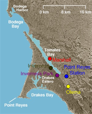
See Inverness Park, California on the map
Directions to Inverness Park, California with public transportation
The following transit lines have routes that pass near Inverness Park, California
 Bus:
Bus:
How to get to Inverness Park, California by bus?
Click on the bus route to see step by step directions with maps, line arrival times and updated time schedules.
Bus stations near Inverness Park, California
- Sir Francis Drake Blvd & Balboa Av,3 min walk,
Bus lines to Inverness Park, California
- 68,Inverness,
What are the closest stations to Inverness Park, California?
The closest stations to Inverness Park, California are:
- Sir Francis Drake Blvd & Balboa Av is 237 yards away, 3 min walk.
Which bus line stops near Inverness Park, California?
68
What’s the nearest bus stop to Inverness Park, California?
The nearest bus stop to Inverness Park, California is Sir Francis Drake Blvd & Balboa Av. It’s a 3 min walk away.
What time is the first bus to Inverness Park, California?
The 68 is the first bus that goes to Inverness Park, California. It stops nearby at 6:25 AM.
What time is the last bus to Inverness Park, California?
The 68 is the last bus that goes to Inverness Park, California. It stops nearby at 8:25 PM.
How much is the light rail fare to Inverness Park, California?
The light rail fare to Inverness Park, California costs about $2.50.
How much is the bus fare to Inverness Park, California?
The bus fare to Inverness Park, California costs about $1.50 - $7.75.
How much is the train fare to Inverness Park, California?
The train fare to Inverness Park, California costs about $1.50 - $7.50.
See Inverness Park, California on the map
Public Transportation to Inverness Park, California
Wondering how to get to Inverness Park, California, United States? Moovit helps you find the best way to get to Inverness Park, California with step-by-step directions from the nearest public transit station.
Moovit provides free maps and live directions to help you navigate through your city. View schedules, routes, timetables, and find out how long does it take to get to Inverness Park, California in real time.
Looking for the nearest stop or station to Inverness Park, California? Check out this list of stops closest to your destination: Sir Francis Drake Blvd & Balboa Av.
Bus:
Want to see if there’s another route that gets you there at an earlier time? Moovit helps you find alternative routes or times. Get directions from and directions to Inverness Park, California easily from the Moovit App or Website.
We make riding to Inverness Park, California easy, which is why over 1.5 million users, including users in Inverness, trust Moovit as the best app for public transit. You don’t need to download an individual bus app or train app, Moovit is your all-in-one transit app that helps you find the best bus time or train time available.
For information on prices of bus, train and light rail, costs and ride fares to Inverness Park, California, please check the Moovit app.
Use the app to navigate to popular places including to the airport, hospital, stadium, grocery store, mall, coffee shop, school, college, and university.
Inverness Park, California Address: Point Reyes Station, CA 94956 street in Inverness
Attractions near Inverness Park, California
The Drake,Point Reyes Medical Clinic,West Marin Health & Human Services,West Marin Storage,Abalone Apothecary,5t 5th St,Bread Vine Baking Company,A St & Highway 1,Point Reyes Station,Eco-Gardening,Poppy Cart,Marlie de Swart Bo-Rage Yarns and Designs,Point Reyes Station, California,Point Reyes Light,Wind Harvest,JB Blunk Estate L,William Lester Gallery,G R O,USPS,La LibertàHow to get to popular attractions in Inverness with public transit
Daly City BART, Daly City,Mountain View VTA Light Rail Station,City of Pleasanton, Pleasanton,California's Great America, Santa Clara,Japantown, Western Addition, Sf,Westgate Shopping Center, San Jose,Travis Air Force Base, Fairfield,Renaissance ClubSport Walnut Creek Hotel, Contra Costa Centre,City of Newark, Newark,Microsoft SVC,Boudin Bakery Café SFO, Sfo,Genentech Inc, South San Francisco,Golden Gate Park, Golden Gate Park, Sf,Usf, Inner Richmond, Sf,City of Menlo Park, Menlo Park,Colma, Colma,Safeway, Hayward,Sonoma County Fairgrounds, Santa Rosa,Nordstrom Stoneridge Mall in Pleasanton, Pleasanton,Sfo, SfoGet around Inverness by public transit!
Traveling around Inverness has never been so easy. See step by step directions as you travel to any attraction, street or major public transit station. View bus and train schedules, arrival times, service alerts and detailed routes on a map, so you know exactly how to get to anywhere in Inverness.
When traveling to any destination around Inverness use Moovit's Live Directions with Get Off Notifications to know exactly where and how far to walk, how long to wait for your line, and how many stops are left. Moovit will alert you when it's time to get off — no need to constantly re-check whether yours is the next stop.
Wondering how to use public transit in Inverness or how to pay for public transit in Inverness? Moovit public transit app can help you navigate your way with public transit easily, and at minimum cost. It includes public transit fees, ticket prices, and costs. Looking for a map of Inverness public transit lines? Moovit public transit app shows all public transit maps in Inverness with all bus, train or light rail routes and stops on an interactive map.
Inverness has 3 transit type(s), including: bus, train or light rail, operated by several transit agencies, including BART, Bay Area Rapid Transit, Muni Metro, Caltrain, VTA, Capitol Corridor, Sonoma Marin Area Rail Transit, MUNI, VTA, SF Cable Car, AC Transit, Dumbarton Express, Golden Gate Transit, County Connection and SamTrans