Directions to Jeceaba with public transportation
The following transit lines have routes that pass near Jeceaba
How to get to Jeceaba by bus?
Click on the bus route to see step by step directions with maps, line arrival times and updated time schedules.
Bus stations near Jeceaba
- Praça Padre José Bosco De Resende | Ponto Final De Jeceaba, 1 min walk,
- Cgs-460 Leste | Ferro Liga, 17 min walk,
Bus lines to Jeceaba
- COMÉRCIO 3734A, Jeceaba ➞ Lafaiete,
- SANDRA 1090.2, Jeceaba ➞ Congonhas Via Caetano Lopes,
- 10, Rodoviária/Ferro Ligas/Esmeril,
What are the closest stations to Jeceaba?
The closest stations to Jeceaba are:
- Praça Padre José Bosco De Resende | Ponto Final De Jeceaba is 33 meters away, 1 min walk.
- Cgs-460 Leste | Ferro Liga is 1251 meters away, 17 min walk.
Which bus lines stop near Jeceaba?
These bus lines stop near Jeceaba: COMÉRCIO 3734A, SANDRA 1090.2.
What’s the nearest bus stop to Jeceaba?
The nearest bus stop to Jeceaba is Praça Padre José Bosco De Resende | Ponto Final De Jeceaba. It’s a 1 min walk away.
What time is the first bus to Jeceaba?
The COMÉRCIO 3734A is the first bus that goes to Jeceaba. It stops nearby at 5:45 AM.
What time is the last bus to Jeceaba?
The COMÉRCIO 3734A is the last bus that goes to Jeceaba. It stops nearby at 8:07 PM.
See Jeceaba on the map
Public Transportation to Jeceaba
Wondering how to get to Jeceaba, Brazil? Moovit helps you find the best way to get to Jeceaba with step-by-step directions from the nearest public transit station.
Moovit provides free maps and live directions to help you navigate through your city. View schedules, routes, timetables, and find out how long does it take to get to Jeceaba in real time.
Looking for the nearest stop or station to Jeceaba? Check out this list of stops closest to your destination: Praça Padre José Bosco De Resende | Ponto Final De Jeceaba; Cgs-460 Leste | Ferro Liga.
Bus: COMÉRCIO 3734A, SANDRA 1090.2, 10.
Want to see if there’s another route that gets you there at an earlier time? Moovit helps you find alternative routes or times. Get directions from and directions to Jeceaba easily from the Moovit App or Website.
We make riding to Jeceaba easy, which is why over 1.5 million users, including users in Jeceaba, trust Moovit as the best app for public transit. You don’t need to download an individual bus app or train app, Moovit is your all-in-one transit app that helps you find the best bus time or train time available.
For information on prices of bus, costs and ride fares to Jeceaba, please check the Moovit app.
Use the app to navigate to popular places including to the airport, hospital, stadium, grocery store, mall, coffee shop, school, college, and university.
Jeceaba Address: Rua Agostinho Ribeiro street in Jeceaba
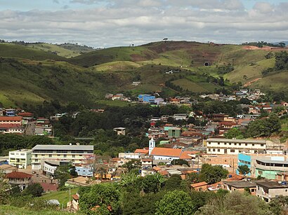
Jeceaba is a municipality in the state of Minas Gerais in the Southeast region of Brazil.Wiki
Attractions near Jeceaba
Assemj,Mega Brilho Lava Jato Jece,Bar Arco Iris,O Rei do Gado,Contabilidade Jeceaba,Loja Bike Moto Taxi Moto Som,Adriana,Raw Cosmeticos,Panificadora Trigo,Posto Machado Jeceaba Ltda,Jeceaba Loterica Ltda,Comissao Provisoria Municipal do Partido Solidariedade,Manu Lanches,Patricia Moveis,Borracharia and Lava Jato Santa Clara,Wilton Fernandes Mont,Canários Bar e Mercear,Startbaby,Agropecuária Jeceaba - a Casa do Fazendeiro,Estação Ferroviária JeceabaHow to get to popular attractions in Jeceaba with public transit
Saúde Mais - Clínica Médica e Odontológica, São Brás Do Suaçuí,Lord Metais & Reciclagem, São Brás Do Suaçuí,Escola de Música de São Brás do Suaçuí, São Brás Do Suaçuí,Brasa Grill Churrascaria e Pizzaria, Alto Maranhao,Carandaí, Conselheiro Lafaiete,Pastelaria e Lanchonete Ki Sabor, Conselheiro Lafaiete,Materiais de Construção Piranguita, Conselheiro Lafaiete,Igreja Cristã Maranata, São Brás Do Suaçuí,Wle Empreendimentos Imobiliários, Conselheiro Lafaiete,Instituto Educacional e Berçario Ninho da Cegonha, Conselheiro Lafaiete,Servico Nacional de Aprendizagem Comercial SENAC Minas, Conselheiro Lafaiete,Jw Topografia, São Brás Do Suaçuí,Centro Automotivo Recupera, Conselheiro Lafaiete,União Clínica Veterinária, Conselheiro Lafaiete,Elohim Distribuidora, Conselheiro Lafaiete,SB UNIFORMES, São Brás Do Suaçuí,Padaria e Confeitaria Califórnia, Conselheiro Lafaiete,Capotaria São Benedito, Conselheiro Lafaiete,Pensao Alvorada, Conselheiro Lafaiete,Studio Pilates Tatiana Salimena, Conselheiro LafaieteGet around Conselheiro Lafaiete Region by public transit!
Traveling around Conselheiro Lafaiete Region has never been so easy. See step by step directions as you travel to any attraction, street or major public transit station. View bus and train schedules, arrival times, service alerts and detailed routes on a map, so you know exactly how to get to anywhere in Conselheiro Lafaiete Region.
When traveling to any destination around Conselheiro Lafaiete Region use Moovit's Live Directions with Get Off Notifications to know exactly where and how far to walk, how long to wait for your line, and how many stops are left. Moovit will alert you when it's time to get off — no need to constantly re-check whether yours is the next stop.
Wondering how to use public transit in Conselheiro Lafaiete Region or how to pay for public transit in Conselheiro Lafaiete Region? Moovit public transit app can help you navigate your way with public transit easily, and at minimum cost. It includes public transit fees, ticket prices, and costs. Looking for a map of Conselheiro Lafaiete Region public transit lines? Moovit public transit app shows all public transit maps in Conselheiro Lafaiete Region with all bus routes and stops on an interactive map.
Conselheiro Lafaiete Region has 1 transit type(s), including: bus, operated by several transit agencies, including Viação Presidente, Comércio, Lubrificantes, Peças, Rota Real Transportes, Turin Transportes, São Judas Transportes, Líder - Viação Carvalho & Costa, Saritur - Santa Rita Transp. Urb. Rodov., Viação Sandra, Empresa Unida Mansur e Filhos