Directions to Käpylän asema (Helsinki) with public transportation
The following transit lines have routes that pass near Käpylän asema
How to get to Käpylän asema by bus?
Click on the bus route to see step by step directions with maps, line arrival times and updated time schedules.
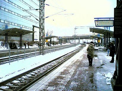
How to get to Käpylän asema by train?
Click on the train route to see step by step directions with maps, line arrival times and updated time schedules.
How to get to Käpylän asema by metro?
Click on the metro route to see step by step directions with maps, line arrival times and updated time schedules.
Bus stops near Käpylän asema in Helsinki
- Käpylän Asema, 1 min walk,
Bus lines to Käpylän asema in Helsinki
- 56, Kalasatama,
- 69, Jakomäki,
- 603, Malmin Sairaala,
- 64, Itä-Pakila,
- 67N, Torpparinmäki,
- 61, Rautatientori-Pukinmäki-Tapaninkylä,
- 61N, Rautatientori-Pukinmäki-Töyrynummi,
- 66, Rautatientori-Maunula-Länsi-Pakila-Paloheinä,
- 67, Rautatientori-Maunula-Pakila-Torpparinmäki,
- 600, Rautatientori-Kartanonkoski-Lentoasema,
- 611, Rautatientori-Siltamäki-Suutarila-Tikkurila,
- 614, Hakaniemi-Tammisto-Ylästö,
- 617, Hakaniemi-Tammisto-Aviapolis,
- 623, Hakaniemi-Peijas,
- 633, Hakaniemi-Ilola-Korso,
- 633N, Rautatientori-Simonkylä-Leinelä-Korso-Ahjo-Keravan asema,
- 643, Hakaniemi-Hyrylä,
- 643K, Hakaniemi-Ruskeasanta-Hyrylä,
- 643N, Rautatientori-Hyrylä-Lahela,
- 665N, Rautatientori-Hyrylä-Järvenpää-Jamppa-Kellokoski,
What are the closest stations to Käpylän asema?
The closest stations to Käpylän asema are:
- Käpylän Asema is 74 meters away, 1 min walk.
Which bus lines stop near Käpylän asema?
These bus lines stop near Käpylän asema: 56, 611, 615, 665.
Which train lines stop near Käpylän asema?
These train lines stop near Käpylän asema: I, P.
Which metro lines stop near Käpylän asema?
These metro lines stop near Käpylän asema: M1, M2.
What’s the nearest bus stop to Käpylän asema in Helsinki?
The nearest bus stop to Käpylän asema in Helsinki is Käpylän Asema. It’s a 1 min walk away.
See Käpylän asema, Helsinki, on the map
Public Transit to Käpylän asema in Helsinki
Wondering how to get to Käpylän asema in Helsinki, Finland? Moovit helps you find the best way to get to Käpylän asema with step-by-step directions from the nearest public transit station.
Moovit provides free maps and live directions to help you navigate through your city. View schedules, routes, timetables, and find out how long does it take to get to Käpylän asema in real time.
Looking for the nearest stop or station to Käpylän asema? Check out this list of stops closest to your destination: Käpylän Asema.
Bus: 56, 611, 615, 665, 69, 603, 64, 67N, 61, 61N, 66, 67, 600.Train: I, P.Metro: M1, M2.
Want to see if there’s another route that gets you there at an earlier time? Moovit helps you find alternative routes or times. Get directions from and directions to Käpylän asema easily from the Moovit App or Website.
We make riding to Käpylän asema easy, which is why over 1.5 million users, including users in Helsinki, trust Moovit as the best app for public transit. You don’t need to download an individual bus app or train app, Moovit is your all-in-one transit app that helps you find the best bus time or train time available.
For information on prices of bus, train and metro, costs and ride fares to Käpylän asema, please check the Moovit app.
Use the app to navigate to popular places including to the airport, hospital, stadium, grocery store, mall, coffee shop, school, college, and university.
Käpylän asema Address: Käpylän asema, Helsinki, Suomi street in Helsinki
Attractions near Käpylän asema
Helsinki,Raide 4,Satotalon punttisali,Aste Helsinki,Saton pääkonttori,Pernod Ricard Finland Oy,Citrus Solutions Oy,Componenta,Sato-Talo,VR Käpylä,Sato-Yhtymä,Theron Catering,Käpylä,HSL 3140 Käpylän asema,Panuntien silta,Helen Sähköverkko Oy,Käpylä,Vr rautatieasema Käpylä,Käpylä,Käpylän Asema KaupunkipyöräasemaHow to get to popular attractions in Helsinki with public transit
Otaniemi, Espoo,Kauppakeskus Iso Omena, Espoo,Musiikkitalo, Helsinki,Prisma, Helsinki,Kukkila, Hollola,Jokiniemi / Ånäs, Vantaa,Bolt Arena, Helsinki,Senaatintori, Helsinki,Töölöntori, Helsinki,Korso, Vantaa,Messukeskus, Helsinki,Terminaali 2, Vantaa,Viikki, Helsinki,Hartwall Arena, Helsinki,Ilola / Gladas, Vantaa,Linnanmaki, Vantaa,Metro Sörnäinen A, Helsinki,Malminkartano / Malmgård, Helsinki,Fitness Club Olarium, Espoo,Viiskulma, HelsinkiGet around Helsinki by public transit!
Traveling around Helsinki has never been so easy. See step by step directions as you travel to any attraction, street or major public transit station. View bus and train schedules, arrival times, service alerts and detailed routes on a map, so you know exactly how to get to anywhere in Helsinki.
When traveling to any destination around Helsinki use Moovit's Live Directions with Get Off Notifications to know exactly where and how far to walk, how long to wait for your line, and how many stops are left. Moovit will alert you when it's time to get off — no need to constantly re-check whether yours is the next stop.
Wondering how to use public transit in Helsinki or how to pay for public transit in Helsinki? Moovit public transit app can help you navigate your way with public transit easily, and at minimum cost. It includes public transit fees, ticket prices, and costs. Looking for a map of Helsinki public transit lines? Moovit public transit app shows all public transit maps in Helsinki with all Bus, Train, Metro, Tram and Ferry routes and stops on an interactive map.
Helsinki has 5 transit type(s), including: Bus, Train, Metro, Tram and Ferry, operated by several transit agencies, including HSL Metro, HSL Tram, HSL Rail, HSL, HSL Ferry, Lehtimäen Liikenne Oy, Tilausliikenne Kuisma Ky, Koiviston Auto Oy, Menevä Oy, Porvoon Liikenne, Kymen Charterline Oy, Koiviston Auto, TAXI KIPI OY, Porvoo