How to get to Kindercare by bus?
Click on the bus route to see step by step directions with maps, line arrival times and updated time schedules.
From Melrose, MA, Melrose
81 minFrom McLean Hospital, Belmont
84 minFrom Terrace Room, Paige Hall, Medford
67 minFrom Ac Hotel Cambridge, Cambridge
39 minFrom Stone Zoo, Stoneham
84 minFrom Medford, MA, Medford
49 minFrom MBTA / Alewife #6, Cambridge
33 minFrom Tufts University, Medford
66 minFrom Wilmington, MA, Wilmington
133 minFrom Hyatt Place Medford, Medford
41 min
Bus stops near Kindercare in Burlington
What are the closest stations to Kindercare?
The closest stations to Kindercare are:
- Cambridge St @ Wall St is 470 yards away, 6 min walk.
- Cambridge St Opp Ray Ave is 639 yards away, 8 min walk.
Which bus lines stop near Kindercare?
These bus lines stop near Kindercare: 350, 354.
What’s the nearest bus station to Kindercare in Burlington?
The nearest bus station to Kindercare in Burlington is Cambridge St @ Wall St. It’s a 6 min walk away.
What time is the first bus to Kindercare in Burlington?
The 354 is the first bus that goes to Kindercare in Burlington. It stops nearby at 5:35 AM.
What time is the last bus to Kindercare in Burlington?
The 350 is the last bus that goes to Kindercare in Burlington. It stops nearby at 10:46 PM.
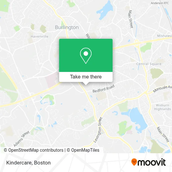
See Kindercare, Burlington, on the map
Public Transit to Kindercare in Burlington
Wondering how to get to Kindercare in Burlington? Moovit helps you find the best way to get to Kindercare with step-by-step directions from the nearest public transit station.
Moovit provides free maps and live directions to help you navigate through your city. View schedules, routes, timetables, and find out how long does it take to get to Kindercare in real time.
Looking for the nearest stop or station to Kindercare? Check out this list of stops closest to your destination: Cambridge St @ Wall St; Cambridge St Opp Ray Ave.
Bus: 350, 354.
Want to see if there’s another route that gets you there at an earlier time? Moovit helps you find alternative routes or times. Get directions from and directions to Kindercare easily from the Moovit App or Website.
We make riding to Kindercare easy, which is why over 1.7 million users, including users in Burlington, trust Moovit as the best app for public transit. You don’t need to download an individual bus app or train app, Moovit is your all-in-one transit app that helps you find the best bus time or train time available.
For information on prices of bus, subway and train, costs and ride fares to Kindercare, please check the Moovit app.
Use the app to navigate to popular places including to the airport, hospital, stadium, grocery store, mall, coffee shop, school, college, and university.
Kindercare Address: 18 Ray Ave street in Burlington
- Burlington Carpet Cleaning,
- Navillus Associates,
- Eagle Bank,
- Prismtech Corporation,
- AAA Burlington Driving School,
- Mom's Organic Market,
- Poison-Ivy.Org,
- Halstead Burlington,
- Eggholic,
- Window World of Boston,
- Physical Therapy Hip Pain,
- Progress,
- Microsoft Northeast District,
- Gutierrez,
- ChargePoint,
- Microsoft Office Burlington,
- Microsoft Technology Center Burlington,
- Boston Entrepreneurs' Network - Enet,
- Massachusetts Oral & Maxillofacial Surgery,
- Gary F Romagna & Associates Law
Places Near Kindercare (Burlington)
- North End, Boston,
- Boston Medical Center, Boston,
- Wilbur Theatre, Boston,
- Leader Bank Pavilion (Leader Bank Pavillion), Boston,
- Isabella Stewart Gardner Museum, Boston,
- Cheers, Boston,
- Mgm Music Hall, Boston,
- Prudential Center, Boston,
- Massachusetts General Hospital, Boston,
- Td Garden, Boston,
- Wang Theater, Boston,
- Castle Island, Boston,
- Boston Children's Hospital, Boston,
- Quincy Market, Boston,
- Faneuil Hall, Boston,
- House Of Blues, Boston,
- Boston Convention & Exhibition Center, Boston,
- Museum Of Science, Boston,
- Boston Common, Boston,
- Seaport District, Boston
How to get to popular places in Boston with public transit
Get around Burlington by public transit!
Traveling around Burlington has never been so easy. See step by step directions as you travel to any attraction, street or major public transit station. View bus and train schedules, arrival times, service alerts and detailed routes on a map, so you know exactly how to get to anywhere in Burlington.
When traveling to any destination around Burlington use Moovit's Live Directions with Get Off Notifications to know exactly where and how far to walk, how long to wait for your line, and how many stops are left. Moovit will alert you when it's time to get off — no need to constantly re-check whether yours is the next stop.
Wondering how to use public transit in Burlington or how to pay for public transit in Burlington? Moovit public transit app can help you navigate your way with public transit easily, and at minimum cost. It includes public transit fees, ticket prices, and costs. Looking for a map of Burlington public transit lines? Moovit public transit app shows all public transit maps in Burlington with all Bus, Train, Subway and Ferry routes and stops on an interactive map.
Boston has 4 transit type(s), including: Bus, Train, Subway and Ferry, operated by several transit agencies, including MBTA, Southeastern Regional Transit Authority, MetroWest Regional Transit Authority, Rhode Island Public Transit Authority, WRTA, Lowell Regional Transit Authority, Merrimack Valley Transit, Montachusett Regional Transit Authority, Cape Cod Regional Transit Authority, Brockton Area Transit Authority, Martha's Vineyard Transit Authority, the WAVE - Nantucket Regional Transit Authority, GATRA, Cape Ann Transportation Authority and Massport