L.B. Blvd. & Tenth NE stop - Sunday schedule
| Line | Direction | Time |
|---|---|---|
| 232 | LAX / Metro Transit Center | 4:41 AM |
| 51 | 51 LB Blvd to Artesia Station | 5:09 AM |
| 46 | 46 Anaheim St to PCH | 5:10 AM |
| 232 | LAX / Metro Transit Center | 5:26 AM |
| 51 | 51 LB Blvd to Artesia Station | 5:39 AM |
| 46 | 46 Anaheim St to PCH | 5:40 AM |
| 232 | LAX / Metro Transit Center | 5:58 AM |
| 51 | 51 LB Blvd to Artesia Station | 6:09 AM |
| 46 | 46 Anaheim St to PCH | 6:10 AM |
| 232 | LAX / Metro Transit Center | 6:30 AM |
| 46 | 46 Anaheim St to PCH | 6:35 AM |
| 51 | 51 LB Blvd to Artesia Station | 6:39 AM |
| 232 | LAX / Metro Transit Center | 7:00 AM |
| 51 | 51 LB Blvd to Artesia Station | 7:09 AM |
| 46 | 46 Anaheim St to PCH | 7:15 AM |
| 232 | LAX / Metro Transit Center | 7:29 AM |
| 51 | 51 LB Blvd to Artesia Station | 7:29 AM |
| 46 | 46 Anaheim St to PCH | 7:48 AM |
| 51 | 51 LB Blvd to Artesia Station | 7:49 AM |
| 232 | LAX / Metro Transit Center | 8:00 AM |
| 51 | 51 LB Blvd to Artesia Station | 8:09 AM |
| 46 | 46 Anaheim St to PCH | 8:18 AM |
| 51 | 51 LB Blvd to Artesia Station | 8:29 AM |
| 232 | LAX / Metro Transit Center | 8:31 AM |
| 46 | 46 Anaheim St to PCH | 8:48 AM |
Directions to L.B. Blvd. & Tenth NE stop (Long Beach) with public transit
The following transit lines have routes that pass near L.B. Blvd. & Tenth NE
 Bus: 173, 232, 3, 51, 93.
- Subway: A LINE.
How to get to L.B. Blvd. & Tenth NE stop by bus?
Click on the bus route to see step by step directions with maps, line arrival times and updated time schedules.
Bus stops near L.B. Blvd. & Tenth NE stop in Long Beach
- Long Beach Blvd & 10th NW, 2 min walk,
- Long Beach / 10th, 2 min walk,
- 10th & Long Beach NW, 2 min walk,
- Anaheim at Lbblvd., 6 min walk,
- Atlantic & 10th NE, 7 min walk,
- Pacific & Tenth NE, 7 min walk,
Subway stations near L.B. Blvd. & Tenth NE station in Long Beach
- 1st Street Station, 15 min walk,
Bus lines to L.B. Blvd. & Tenth NE stop in Long Beach
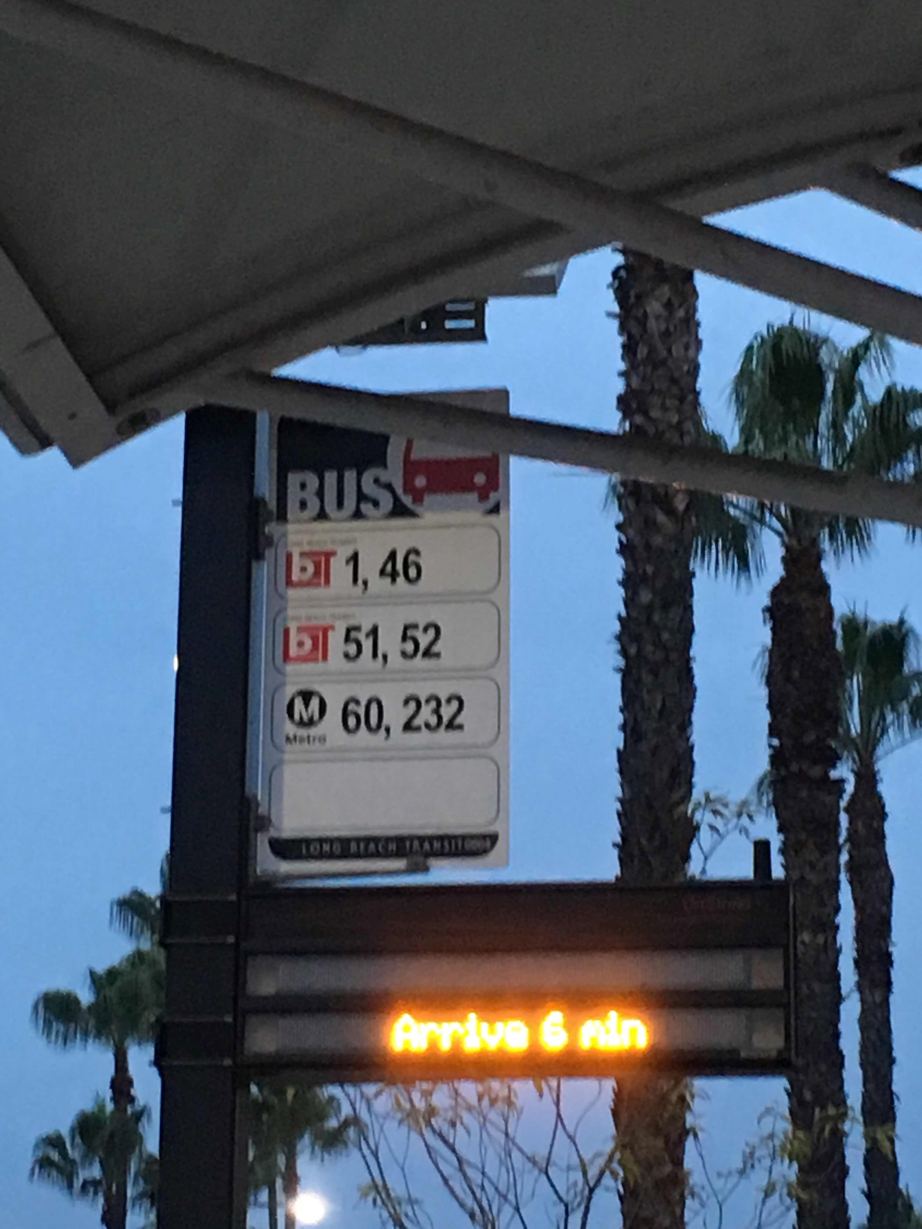
- 46, 46 Anaheim St to CSULB,
- 51, 51 LB Blvd to Artesia Station,
- 60, Downtown LA - Artesia Station -,
- 232, LAX/Metro TC - Long Beach-Via Sepulveda Bl - Pch,
- PASSPORT, Passport North to Downtown,
- 41, 41 Easy-Anaheim to CSULB,
- 61, 61 Atlantic to Downtown,
- 3, Redondo Beach Pier,
- R3, Mary K Giordano Regional Transit Center,
- 172, 172 Palo Verde to Norwalk Sta,
- 173, 173 Studebaker to Norwalk Station,
- 174, 174 PCH to Ximeno,
- 182, 182 Pacific to Wardlow Station,
What are the closest stations to L.B. Blvd. & Tenth NE?
The closest stations to L.B. Blvd. & Tenth NE are:
- Long Beach Blvd & 10th NW is 104 yards away, 2 min walk.
- Long Beach / 10th is 115 yards away, 2 min walk.
- 10th & Long Beach NW is 118 yards away, 2 min walk.
- Anaheim at Lbblvd. is 464 yards away, 6 min walk.
- Atlantic & 10th NE is 521 yards away, 7 min walk.
- Pacific & Tenth NE is 540 yards away, 7 min walk.
- 1st Street Station is 1248 yards away, 15 min walk.
Which bus lines stop near L.B. Blvd. & Tenth NE?
These bus lines stop near L.B. Blvd. & Tenth NE: 173, 232, 3, 51, 93.
Which subway line stops near L.B. Blvd. & Tenth NE?
A LINE (Downtown Long Beach Station)
What’s the nearest subway station to L.B. Blvd. & Tenth NE in Long Beach?
The nearest subway station to L.B. Blvd. & Tenth NE in Long Beach is 1st Street Station. It’s a 15 min walk away.
What’s the nearest bus station to L.B. Blvd. & Tenth NE in Long Beach?
The nearest bus stations to L.B. Blvd. & Tenth NE in Long Beach are Long Beach Blvd & 10th NW, Long Beach / 10th and 10th & Long Beach NW. The closest one is a 2 min walk away.
What time is the first subway to L.B. Blvd. & Tenth NE in Long Beach?
The A LINE is the first subway that goes to L.B. Blvd. & Tenth NE in Long Beach. It stops nearby at 3:42 AM.
What time is the last subway to L.B. Blvd. & Tenth NE in Long Beach?
The A LINE is the last subway that goes to L.B. Blvd. & Tenth NE in Long Beach. It stops nearby at 1:40 AM.
What time is the first bus to L.B. Blvd. & Tenth NE in Long Beach?
The 60 is the first bus that goes to L.B. Blvd. & Tenth NE in Long Beach. It stops nearby at 3:04 AM.
What time is the last bus to L.B. Blvd. & Tenth NE in Long Beach?
The 60 is the last bus that goes to L.B. Blvd. & Tenth NE in Long Beach. It stops nearby at 4:26 AM.
L.B. Blvd. & Tenth NE station
 Taken by Anonymous
See L.B. Blvd. & Tenth NE stop, Long Beach, on the map
Public transit to L.B. Blvd. & Tenth NE stop in Long Beach
Looking for directions to L.B. Blvd. & Tenth NE in Long Beach, United States?
Download the Moovit App to find the current schedule and step-by-step directions for Bus or Subway routes that pass through L.B. Blvd. & Tenth NE.
Looking for the nearest stops closest to L.B. Blvd. & Tenth NE ? Check out this list of closest stops to your destination: Long Beach Blvd & 10th NW; Long Beach / 10th; 10th & Long Beach NW; Anaheim at Lbblvd.; Atlantic & 10th NE; Pacific & Tenth NE; 1st Street Station.
Bus: 173, 232, 3, 51, 93, 46, 60, PASSPORT, 41, 61.Subway: A LINE.
We make riding on public transit to L.B. Blvd. & Tenth NE easy, which is why over 1.5 million users, including users in Long Beach trust Moovit as the best app for public transit.
Use the app to navigate to popular places including to the airport, hospital, stadium, grocery store, mall, coffee shop, school, college, and university.
The first line to this stop is 232, at 4:41 AM, and the last line is 60 at 4:05 AM.
This stop serves Long Beach Transit and Metro’s lines
- Long Beach Blvd & 10th NW,
- Long Beach / 10th,
- 10th & Long Beach NW,
- Anaheim at Lbblvd.,
- Atlantic & 10th NE,
- Pacific & Tenth NE
Bus stops near L.B. Blvd. & Tenth NE stop
- 1st Street Station
Subway station near L.B. Blvd. & Tenth NE station
- Jefferson / Vermont,
- De Soto / Lassen,
- Maple / 36th,
- Martin Luther King Jr / Vermont,
- Florence / Vermont,
- Foothill / Maclay,
- Riverside / Whitsett,
- Figueroa / Avenue 54,
- Santa Monica / Vine,
- Roscoe / Hazeltine,
- Washington Blvd & Eastern Ave,
- Lorena / Whittier,
- Lorena / 8th,
- Willow & Redondo SE,
- Glenoaks / Paxton,
- Hawthorne Blvd & Crest Rd (Northbound),
- Expo / Western,
- Flower St & 12th St (Southbound),
- Chevy Chase at Glendale,
- Commerce
Popular public transit stations in Long Beach
Get around Long Beach by public transit!
Traveling around Long Beach has never been so easy. See step by step directions as you travel to any attraction, street or major public transit station. View bus and train schedules, arrival times, service alerts and detailed routes on a map, so you know exactly how to get to anywhere in Long Beach.
When traveling to any destination around Long Beach use Moovit's Live Directions with Get Off Notifications to know exactly where and how far to walk, how long to wait for your line, and how many stops are left. Moovit will alert you when it's time to get off — no need to constantly re-check whether yours is the next stop.
Wondering how to use public transit in Long Beach or how to pay for public transit in Long Beach? Moovit public transit app can help you navigate your way with public transit easily, and at minimum cost. It includes public transit fees, ticket prices, and costs. Looking for a map of Long Beach public transit lines? Moovit public transit app shows all public transit maps in Long Beach with all Bus, Train, Subway, Ferry and Funicular routes and stops on an interactive map.
Los Angeles has 5 transit type(s), including: Bus, Train, Subway, Ferry and Funicular, operated by several transit agencies, including Metro, Alhambra Community Transit, Arcadia Transit, ART, Artesia Transit, AVTA, Baldwin Park Transit, Beach Cities Transit, Beaumont Transit, Bell Gardens Town Trolley, Bellflower Bus, Big Blue Bus, Burbank Bus, Calabasas Trolley and Camarillo Area Transit