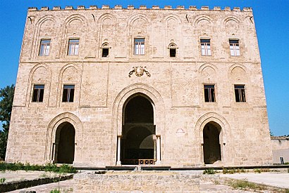
See La Zisa, Palermo, on the map
- Camera Canon EOS 300V with Canon Zoom Lens EF 28-90mm
- Scan from the film negative
Directions to La Zisa (Palermo) with public transportation
The following transit lines have routes that pass near La Zisa
 Bus:
Bus: - Train:
How to get to La Zisa by bus?
Click on the bus route to see step by step directions with maps, line arrival times and updated time schedules.
How to get to La Zisa by train?
Click on the train route to see step by step directions with maps, line arrival times and updated time schedules.
Bus stations near La Zisa in Palermo
- L'Emiro - Guerrazzi,4 min walk,
Bus lines to La Zisa in Palermo
- 124,Parcheggio Emiri <> Staz. Centrale,
What are the closest stations to La Zisa?
The closest stations to La Zisa are:
- L'Emiro - Guerrazzi is 258 meters away, 4 min walk.
Which bus lines stop near La Zisa?
These bus lines stop near La Zisa: 106, 124, H2.
Which train line stops near La Zisa?
B
What’s the nearest bus stop to La Zisa in Palermo?
The nearest bus stop to La Zisa in Palermo is L'Emiro - Guerrazzi. It’s a 4 min walk away.
See La Zisa, Palermo, on the map
- Camera Canon EOS 300V with Canon Zoom Lens EF 28-90mm
- Scan from the film negative
Public Transit to La Zisa in Palermo
Wondering how to get to La Zisa in Palermo, Italy? Moovit helps you find the best way to get to La Zisa with step-by-step directions from the nearest public transit station.
Moovit provides free maps and live directions to help you navigate through your city. View schedules, routes, timetables, and find out how long does it take to get to La Zisa in real time.
Looking for the nearest stop or station to La Zisa? Check out this list of stops closest to your destination: L'Emiro - Guerrazzi.
Bus:Train:
Want to see if there’s another route that gets you there at an earlier time? Moovit helps you find alternative routes or times. Get directions from and directions to La Zisa easily from the Moovit App or Website.
We make riding to La Zisa easy, which is why over 1.5 million users, including users in Palermo, trust Moovit as the best app for public transit. You don’t need to download an individual bus app or train app, Moovit is your all-in-one transit app that helps you find the best bus time or train time available.
For information on prices of bus and train, costs and ride fares to La Zisa, please check the Moovit app.
Use the app to navigate to popular places including to the airport, hospital, stadium, grocery store, mall, coffee shop, school, college, and university.
Location: Palermo
- Camera Canon EOS 300V with Canon Zoom Lens EF 28-90mm
- Scan from the film negative
Attractions near La Zisa
Palazzo della Zisa,1,Museo Dell'Islam,Piazza Zisa,Castello Della Zisa,Biglietteria,Chiesa di Santo Stefano Protomartire alla Zisa,Chiesa Annunziata alla Zisa,Cappella Santissima Trinità,Zisa,Chiesa della Zisa,Piazza Zisa / Villa Nicolosi,Piazza Zisa 1,Scruscio,Piazza Zisa 21,Via Cesare Cantù,Via Villa Nicolosi,Soprintendenza Beni Culturali e Ambientali,Arco Zisa,Villa NicolosiHow to get to popular attractions in Palermo with public transit
Villabate, Villabate,Elettronica Cicala, Palermo,Oliver, Palermo,Piazza Vittorio Emanuele Orlando, Palermo,Fontana Del Drago, Monreale,Trapani, Trapani,Parco Uditore, Palermo,Trapani,Villagrazia, Palermo,Trattoria Il Delfino, Palermo,Palazzo Dei Normanni, Palermo,Lido Apollo, Cefalù,Policlinico "Paolo Giaccone", Palermo,Capolinea Bus Prestia e Comandè, Cinisi,Terminal Notarbartolo, Palermo,A Casa, Palermo,Stazione di Palazzo Reale Orleans, Palermo,Baida, Palermo,Al Massimo, Palermo,Valdesi, PalermoGet around Palermo by public transit!
Traveling around Palermo has never been so easy. See step by step directions as you travel to any attraction, street or major public transit station. View bus and train schedules, arrival times, service alerts and detailed routes on a map, so you know exactly how to get to anywhere in Palermo.
When traveling to any destination around Palermo use Moovit's Live Directions with Get Off Notifications to know exactly where and how far to walk, how long to wait for your line, and how many stops are left. Moovit will alert you when it's time to get off — no need to constantly re-check whether yours is the next stop.
Wondering how to use public transit in Palermo or how to pay for public transit in Palermo? Moovit public transit app can help you navigate your way with public transit easily, and at minimum cost. It includes public transit fees, ticket prices, and costs. Looking for a map of Palermo public transit lines? Moovit public transit app shows all public transit maps in Palermo with all bus or train routes and stops on an interactive map.
Palermo has 2 transit type(s), including: bus or train, operated by several transit agencies, including AMAT Palermo S.p.A., AMAT Palermo S.p.A., Trenitalia, Prestia e Comandè, ATM SpA Trapani, Sommatinese Viaggi, Segesta Autolinee, Autoservizi Taormina, Autoservizi Russo, Autoservizi Salemi, Nancini & Saso, Anselmo Cacciatore & C., SAIS Trasporti, Autolinee Giordano S.r.l and Caronte & Tourist